NIdaho Almost Was In Washington
A political rivalry between two would-be Idaho governors, a fight over where Washington's capital should be, 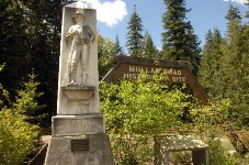 gold strikes in the Idaho Panhandle and more played into the current-day shape of the state of Idaho, according to historic maps unveiled to the Joint Finance-Appropriations Committee today after its budget hearing on the Idaho State Historical Society. Under one, drawn by Lt. John Mullan, the entire North Idaho Panhandle would have become part of Washington. Under the other, drawn by William H. Wallace, not only the Panhandle but all of Montana and most of Wyoming were drawn into the new Idaho Territory/Betsy Russell, Eye On Boise. More here. (Jesse Tinsley SR file photo: A stone marker and sign sit at the Fourth of July pass commemorating the road built from Missoula to Walla Walla in 1862 under Capt. John Mullan's supervision)
- Bill would ban tanning beds for minors
- Thayn's '8 in 6' plan passes House 58-12
- House panel takes up oil/gas drilling legislation
- Idaho biz, ag groups talk economic incentives w/committees
- Whitehead on truck fees: Would 'look after interests of industry/ITD
- Senate R's caucus, then next further amendments to anti-Occupy bill
Question: Would you North Idahoans want to be part of Washington state?