New pedestrian pathway added to proposed Target site; here’s the map
Today's story on the planned Target store in the Southgate area is one that begs for a map.
Much of the discussion from Wednesday's meeting of the city's citizen Design Review Board was about making the proposed 15-acre site more pedestrian friendly.
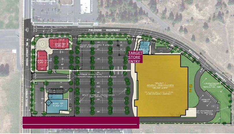
This story needs a map to explain some of the issues. CLICK the MAP above to see a larger version if you can't see this one clearly.
The proposed Target store is the yellow rectangle to the right. Palouse Highway is the upper street; Regal is on the left.
Developer Dave Black and architect Gary Bernardo fully agreed with one specific suggestion from the Southgate Neighborhood Council, that an extra pedestrian path be added from Regal, into the project along the southern boundary. The Design Review Board incorporated that suggestion in its recommendations.
Board Member Colleen Gardner made the point that south of the site are apartments and residences, and that unless the south-boundary walk were added, the temptation to cut through the parking lot would increase the risks to walkers taking that shortcut. The Target store entrance, noted in the map, is at the northwest corner of that building.
The map above is modified from one provided by Bernardo-Wills Architects, of Spokane.
The fuschia-colored bar in the map shows the proposed path along the south edge. It would go to the corner of Target and then connect to a walkway north to the entrance..
The City planning department director must still approve the plan before Black can apply for permits. He said the project could start work as early as this summer, with Target opening next year.