‘Megathrust’ not a surprise, scientists say

Scientists describe Sunday’s devastating earthquake off the island of Sumatra as a “megathrust” – a grade reserved for the most powerful shifts in the Earth’s crust.
The term doesn’t entirely capture the awesome power of the fourth-largest earthquake since 1900, or the tsunami catastrophes it spawned for coastal areas around the Indian Ocean.
Despite its power, the quake itself was not much of a surprise, scientists said Monday.
Sumatra is one of the most earthquake-prone places in the world, sitting atop one of the handful of sites where several plates of the planet’s crust overlap and grind. Colossal pressures build up over decades, only to release in a snap.
“These subduction zones are where all the world’s biggest earthquakes are produced,” said geologist Kerry Sieh of the California Institute of Technology. “Sunday was one of the biggest earthquakes in the region in the past 200 years.”
How powerful? By some estimates, it was equal to detonating a million atomic bombs.
Sieh and other scientists said it probably jolted the planet’s rotation. “It causes the planet to wobble a little bit, but it’s not going to turn Earth upside down,” Sieh said.
Researchers also speculated on the extent to which the jolt might have changed Sumatra’s coastline. Extensive damage and flooding was preventing investigators from immediately reaching the scene.
Seismologists said the epicenter of Sunday’s quake was more than 5.5 miles below the Indian Ocean off the west coast of Sumatra and about 150 miles south of the city of Bandah Aceh on the island’s northern tip.
Beneath the ocean floor, the quake occurred along a long north-south fault where the edge of the Indian plate dives below the Burma plate. A sea floor feature known as the Sunda Trench marks where the Indian plate begins its grinding decent into the Earth’s hot mantle.
Complicating matters, the edges of three other tectonic plates also bump here, with the Indian and Australian plates slowly sliding northwest relative to the Burma plate.
A magnitude 8.0 earthquake on the island’s southern tip was the most deadly tremor of 2000, causing at least 103 fatalities and more than 2,000 injuries. Giant quakes also rocked the area in 1797, 1833 and 1861.
But they were preludes to Sunday’s event.
Pressed from many directions, stress built up along the fault line off the Sumatra coast. A north-south fault ruptured along a 745-mile stretch, or about the length of California. It started offshore, then zigzagged inland beneath Sumatra’s northern tip and up beneath the Andaman Islands almost to the coast of Myanmar.
Similar to quakes on the San Andreas fault in California, the tremor caused one side of the fault to slide past the other. The rupture released energy like shock waves, especially to the east and west.
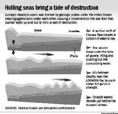
While ground shaking damaged buildings and roads on Sumatra, the real havoc was caused by large ocean waves in the Bay of Bengal and Indian Ocean that were displaced by the quake. Known as tsunamis, the waves obliterated seacoast resorts and communities as far away as Somalia in East Africa.
By Monday, according to the International Tsunami Warning Center in Hawaii, some energy from Sunday’s waves sifted into the Pacific Basin.
At Manzanillo, Mexico, waves rose more than 8 feet. Minor fluctuations were reported in New Zealand and Chile, where waves rose between one and two feet. In the United States, Hawaii reported almost no wave changes, while San Diego saw waves rise less than a foot.