Bringing back the Rio Salado
PHOENIX – The dust, rocky soil and blazingly hot summers make it hard to imagine why anyone would have settled here before air conditioners and sprinkler systems.
But a century ago, Phoenix was a riverside community, a settlement with sometimes flowing water and even an occasional flood as the Salt River ebbed and flowed with the desert seasons.
Eventually, dams upstream tamed the water supply but dried up the riverbed, turning it into a barren ribbon punctuated by gravel mines and by abandoned cars and other junk.
Now that is starting to change.
The U.S. Army Corps of Engineers and local governments are working to return water to the riverbed and trees and vegetation to its banks. Sections of the Salt River in the metropolitan area, totaling some 40 miles, are in various stages of study or rehabilitation.
“Our goal isn’t to establish it to presettlement conditions. It’s never going to happen,” said Kayla Eckert, study manager for the Army Corps of Engineers. “We’re trying to create something that’s sustainable.”
That means the river would have seasonally flowing water and small pools and would be flanked by native trees like willows, cottonwoods and mesquite.
Stretches of the Rio Salado project – Spanish for Salt River – in Phoenix and Tempe are under construction. Tempe even has a 200-acre Town Lake in a separate development in the river channel. A wetlands demonstration project, Tres Rios, is already done.
Restoration has required removal of tons of junk.
“You could probably build a building with all of the stuff that’s been pulled out of there. … I mean, we pulled out full cars,” said Kris Baxter, economic development and marketing coordinator for the city of Tempe.
Water for the projects is effluent, shallow groundwater and storm or irrigation runoff.
The Salt River began to dry up with the construction of Roosevelt Dam, which was completed in 1911. Five other dams were later built on the Salt River and its tributary, the Verde River.
The dams controlled the rivers and provided a steady water supply, allowing Phoenix to grow from a tiny desert settlement to the nation’s sixth-largest city.
Before the Roosevelt Dam, the Salt River was “a river that had a mind of its own,” said Shelly Dudley, a historical analyst for Salt River Project, the utility that distributes both water and the electricity generated at the dams.
“Those were times when it flooded deep and wide,” she said. “You also had times when there was very limited water in the Salt River.”
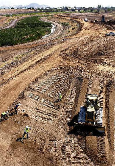
In the Phoenix project – a five-mile stretch first discussed 11 years ago – even with heavy equipment rumbling through the riverbed, ducks and herons can be seen swimming and flying around the river bottom. Ultimately, an estimated 70,000 shrubs and trees will be planted in the 592-acre area, said Walt Kinsler, project manager for the development.
Before construction started, that area of the river bottom was filled with junk, and debris washed down in floods. Except for sparse grass and an occasional tree, the banks were barren.
“It was just a big dust bowl,” Kinsler said.
The Phoenix project should be open next year. The first phase of the Tempe project is nearly done. Proposals for other stretches are still being studied and refined.
Karen Williams, the river project coordinator for Phoenix, said even though it took years to get her city’s project off the ground, it’s been exciting to see the changes actually take place.
“If it had been easy, a project like this would have been done years ago,” she said.