St. Joe wetlands drowning
ST. MARIES – The St. Joe River isn’t so shadowy anymore.
Hundreds of cottonwoods that lined the banks along the lower portion of the river have drowned in recent years. Most of the trees have fallen and floated away. A few poke out of the shallow water, their bare trunks bleached like old bones. The dark soil also has melted into the water, turning the once-braided river delta into an open lake.
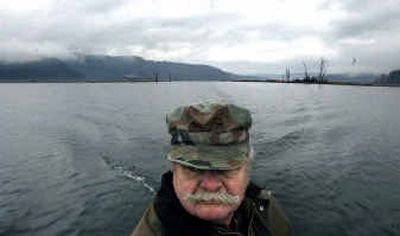
Retired U.S. Marine Frank Werner is leading a solo charge to protect what’s left. On a blustery morning last week, Werner, of St. Maries, offered a tour of the disappearing delta in his homemade duck boat.
“We just crossed the old levee,” Werner said as his boat floated over a mound of dirt about a foot below the surface.
Trees, dogwood shrubs and rushes once grew in the boat’s wake. The area was home to beavers, ducks, herons, songbirds and countless species of insects and amphibians. Werner, a decoy carver of national renown, even had a duck blind on one of the levees before it washed away.
Decades of artificially high water levels on Lake Coeur d’Alene during summers have flooded the area and allowed more powerboats to cruise upriver. The boat wakes and high water have erased nearly a mile of natural levees along the lower river and flooded thousands of acres of seasonal wetlands. Miles more are at risk, Werner said.
Although swamps and trees have been lost, the higher water has meant better river conditions for boaters and deeper dock access for hundreds of property owners along Lake Coeur d’Alene. Avista Utilities, which regulates the lake level with its Post Falls dam, is seeking another 30- to 50-year dam operating license from the federal government.
For the past two years, Werner has participated in negotiations over the utility’s lake management plan – he wants to see the summer lake level dropped by 2 feet and the levees rebuilt. But other participants in the talks – tourism businesses and lake property owners – are fighting to extend existing summer lake levels for at least two weeks longer each season.
Despite evidence of the loss, Werner doubts the lake levels will ever be dropped. “Money talks and merit walks,” he said, motoring his boat downstream toward the Chatcolet Bridge, near the official confluence of the river and lake. Even if the summer levels remain at 2,128 feet above sea level, the utility has proposed measures to slow the erosion, including spending $150,000 each year for the first 15 years of its new license to build wedge-shaped rock weirs. The structures are meant to absorb energy from wakes and waves.
Below the bridge, a small strip of levee still breaks the surface of the water. Bare roots now poke out of the mud. The sight and sound of Werner’s small boat prompted nearby flocks of widgeon and mallards to burst off the water. Werner slowed the motor and watched the ducks. They flew above the river, which looked like dull copper from the glint of the low November sun.
Werner began duck hunting in the lower St. Joe in 1974 when he finished a 20-year career in the Marines, including duty in Vietnam. Back then, “it was shadowy all the way to the bridge,” Werner said.
The levees are mostly gone, but they still stand about a mile upstream from the bridge. Behind the levees, much of what was once seasonal wetlands are now flooded most of the year. Such wetlands, Werner said, contain nature’s choicest ingredients for life: “Fresh dirt, fresh nutrients, sunshine and moisture.”
The levees were created through thousands of years of fluctuating river levels. In spring, a flush of snowmelt surged out of the mountains, down the St. Joe and into Lake Coeur d’Alene. As the runoff tapered, sediment settled on the riverbanks, building up year after year. The water also spilled over the earthen mounds, flooding nearby wetlands. In summer, the lake level dropped, leaving the levees high, dry and bursting with life.
The natural levee system is an ecological treasure, said Robert Matt, lake resources manager for the Coeur d’Alene Tribe. The levees were strong enough to withstand massive spring floods, but they cannot survive in an environment where the flooding lasts each year for three or four months longer than nature designed.
“The name ‘Shadowy St. Joe River’ comes from these levees,” Matt said. “The whole history of the river corridor originates from the beauty of those levees. There’s a lot of ecological trouble now for those levees. They may not be recoverable.”
Without the Post Falls dam, Lake Coeur d’Alene would typically cover about 26,000 acres during dry months of summer, Matt said. Nowadays, the lake covers 48,000 acres and the high pool extends more than 20 miles up the St. Joe River. Much of the flooded area was seasonal wetlands. The flooded areas are also becoming colonized by invasive milfoil, which crowds out native plants and has little habitat value for fish and wildlife.
“The loss is profound,” Matt said.
The effects of the higher water are less noticeable along the deeper, steeper north shore of the lake, near the city of Coeur d’Alene, Matt said.
A 2004 study commissioned by Avista found the high lake levels “contributing to the ongoing erosion,” of the St. Joe levees, as well as the shorelines of the Coeur d’Alene and St. Maries rivers. The erosion is most pronounced on the St. Joe, according to the study. The official figure puts 30 to 50 percent of the blame on higher summer lake levels, but company officials say the increased number of powerboats is also a factor. A generation ago, fewer boats were on the lake, said Speed Fitzhugh, of Avista.
“Today, there are thousands of families on the lake and the average family has three boats,” Fitzhugh said, in comments made Thursday during a meeting on the company’s management plans. “Most of the boats are larger than what existed years ago.”
The Coeur d’Alene Tribe has no official position yet on what it feels would be an appropriate summer lake level, Matt said. The tribe will play a significant role in the final decision, however, because its land is flooded by the high summer lake levels.
“We want to protect what’s left,” Matt said. “We’re hoping to find some good, reasonable compromise. We understand the importance to the local economy of the lake level. We’re rooted in the service and hospitality business also.”
Making informed decisions has not been easy, Matt said, because not enough scientific research has been conducted. The study commissioned by Avista looked at the effects over a single year, he said. “The tribe’s been seeking scientific investigations to understand the problem. It’s been quite a bit of a struggle to see that information being produced because of the potential implications.”
Avista is now being asked to keep the lake levels higher for at least two more weeks in September. The utility currently begins lowering the lake level the week after Labor Day. The lake is lowered by about 8 feet to create more room for spring runoff. A coalition of local governments and businesses asked the utility Thursday to extend the high-water season. The proposal was presented by John Barlow, a manager with Coeur d’Alene-based Hagadone Hospitality, which operates a major resort, marinas and restaurants on the lake. After making the presentation Thursday, Barlow disagreed with concerns that the longer season would further harm the wetlands and levees.
“I personally don’t agree that two more weeks has any effects,” Barlow said.
The additional two weeks would give mean up to 3 more inches of water for lake moorages, which is particularly critical to homeowners who park boats in the shallow reaches of the Spokane River above the Post Falls dam, Barlow said. “More than 3 inches to them puts them out of business.”
Avista officials said they would consider the idea.
Werner said two weeks of additional high water could accelerate the loss of the levees and wetlands. The lower water during the final days of the summer growing season allows some plants to take root and anchor the mud, he said. Werner also characterized the higher lake level as a “freebie” for wealthy lake home owners. The utility’s customers will have to fund programs to offset habitat problems caused by the higher levels, he added.
“We’re going to have to settle for the best we can get,” Werner said. “There’s economic realities to keeping the summer level high. But I think I brought a lot of attention to a lot of people to the values of this system. I feel I’ve accomplished that.”