Hurricane picks up energy

HOMESTEAD, Fla. – One day after Katrina delivered a soggy surprise wallop to some of Miami’s southwestern suburbs, where streets and neighborhoods were under water Friday, emergency planners were bracing for a potential second landfall by the hurricane as an even more dangerous storm.
After crossing the southern tip of the Florida peninsula, where its winds and downpours Thursday evening led to widespread street flooding and at least six deaths, Katrina reached the warm waters of the Gulf of Mexico, where it absorbed enough energy to boost the speed of its sustained winds to 100 mph. Forecasters said the storm, a Category 2 hurricane, might intensify further as it turned north and headed toward the Gulf Coast.
“We are looking at a major hurricane: a strong Category 3 or perhaps a 4 at landfall,” said Ben Nelson, state meteorologist for the Florida Division of Emergency Management in Tallahassee, the capital. “We expect it to hit landfall sometime on Monday.”
A Category 3 hurricane carries highly destructive sustained winds of 111 to 130 mph, a Category 4 has even more damaging winds of 131 to 155 mph. As Katrina’s course stood Friday, it could make its second landfall anywhere from Florida’s Big Bend region to New Orleans, Nelson said.
In Florida’s Panhandle, officials and residents were monitoring what could become the third big hurricane to strike their area in less than a year. The region was hammered in 2004 by Hurricane Ivan, and last month by Hurricane Dennis.
“We’re still cleaning up the debris from Hurricane Dennis,” Sonya Smith, spokeswoman for Escambia County, Fla., government, said from Pensacola. “There are still tree limbs on the roadside and homes with blue roofs (tarps). We have buildings which have lost one, even two walls, that haven’t been repaired. It’s just been too soon.”
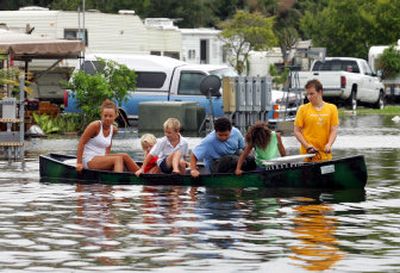
In Homestead, Kendall, Naranja, Goulds and other southern Miami suburbs, streets and parking lots, and some homes, were flooded Friday with pools of tepid water left behind by Katrina. Then a Category 1 hurricane, the storm had been moving westward most of Thursday, but took an unexpected southerly jog, catching many residents of southern Miami-Dade County unaware. They had been counting on the storm to soak Fort Lauderdale and other areas in Broward County to the north.
“The hurricane’s heaviest rainfall, 13 1/4 inches, was registered by a rain gauge in Homestead, the South Florida Water Management District said. Elsewhere in Miami-Dade County, between six and 10 inches of rain fell.
Two male boaters died in the Dinner Key area of Miami, one from injuries suffered when Katrina tossed around his 25-foot boat, the other after his houseboat capsized in the storm.
Broward County authorities reported four hurricane-related fatalities: an elderly woman hit by a falling tree in Davie, a 79-year-old man killed in a car crash in Cooper City, a 25-year-old man crushed by a falling tree as he sat in his car in Fort Lauderdale, and a Plantation man struck by yet another tree as he surveyed storm damage to his home.
Sporadic rain continued throughout South Florida on Friday.