Circling Rainier: Wonderland Trail

While “Near Nature, Near Perfect,” might be a stretch for Spokane, the city’s slogan would be an understatement for the 94-mile Wonderland Trail that circumnavigates Mount Rainier. From rain forests to glaciers and slugs to mountain goats, the entire Pacific Northwest mountain experience is packed into this one classic loop. That said, it’s not for everybody.
The Wonderland is not a wilderness experience in the sense of the puckering solitude found deep in the Bob Marshall Wilderness of Montana or in just about any park or refuge in Alaska. Backpackers on the Wonderland Trail can:
•Bail out to a road in a day from anywhere on the route.
•Drop off or mail food caches to several ranger stations around the trail.
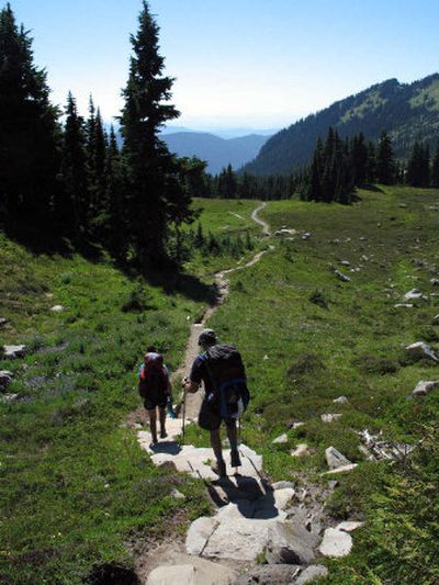
•Pass dozens of hikers a day on several stretches.
•Encounter heavy vehicle traffic near Reflection Lakes where the trail shares the shoulder of the main road through Mount Rainier National Park.
•Find a privy of some sort at every backcountry campsite.
•Enjoy a dining room and hotel along the trail at Longmire or refuel with a greasy gut bomb and a huge ice cream cone at the Sunrise snack bar.
On the other hand, hiking the entire Wonderland Trail is no cakewalk. The elevation profile looks like the surf in a raging ocean storm.
Even though it’s the most meticulously maintained long-distance trail in Washington, backpackers going the distance around the several square miles of ice caking Mount Rainier will:
•Gain and lose nearly three times more elevation than the climbers who trudge to the summit.
•Gamble with unpredictable weather that can change in minutes from sunny and hot to a soaking, chilling whiteout.
■Face the common occurrence of bridge washouts that could pose the undesirable choice of abandoning the trip or fording a raging glacial-melt stream.
The overriding attraction in any of these considerations is the trail’s centerpiece. For a week or more, Wonderland Trail hikers are intimately associated with 14,410-foot Mount Rainier, the most massive mountain in the West.
Even when the volcano is shrouded with clouds, a hiker can hear the rumbling rocks and ice from Rainier’s 25 named glaciers and savor the sounds of countless rivulets, streams, and waterfalls fed by up to 1,100 inches of annual snowfall.
In nine days of backpacking around the mountain last August, I never saw a backpacker hiking with the white buds of an iPod in his ears.
Following is a little of what I did see on the route based on a group trip Frank Otto and his daughter Elsbeth shared with me and my daughter, Brook.
Keep in mind that Wonderland Trail backpackers each night must camp at one of the 18 designated backcountry campsites around the mountain. Where you start and how far you hike each day depends on your luck with securing the required campsite reservations.
Friends of mine have blitzed the trail in four days. We met two sixty-something ladies fully enjoying their leisurely two-week trip.
Hikers will share the same trail around Rainier, yet all will see and experience something different. Here’s a sample of our experience.
Day before the hike
Details, details. As we check in for backcountry permits at White River Ranger Station, the dads assure the girls that the 25-mile day with 7,000 feet of elevation gain we drew midway through our itinerary would be no sweat. But just in case, we ask the ranger if there’s an opening at the Devil’s Dream Camp that would allow us to shorten that day by 10 miles. I’m not sure I need to sprout tears and get on my knees and beg, but it works.
We shuttle our food cache in mouse-proof plastic buckets to Sunrise Ranger Station.
Day 1
Box Canyon to Indian Bar,
8 miles.
After 10 straight days of virtually cloudless weather across the Pacific Northwest, we start our trip by climbing all morning in a mist up the Cowlitz Divide. Clouds hide Rainier but give us welcome relief from the searing sun that’s baking Eastern Washington at 100 degrees.
Deprived of a distant view, we turn attention to the rampage of wildflowers at our feet. Tracks of splayed hooves signal that elk have hastily departed the trail ahead of us. Denuded ground around rock outcropping advertises marmot zones. We meet two teenagers who say they have learned to talk to the marmots in their week on the trail. To prove it, they begin whistling.
The girls move on, quickly. Frank and I let them go ahead to clear spider webs that cross trail.
Little Tahoma, Cowlitz Chimneys and Ohanapecosh Glaciers play peek-a-boo through the clouds.
Realizing what we forgot: Brook, headlamp. Elsbeth, Camelbak — she’s thankful for my extra waterbottle; shares chocolate bar with coaxing.
Waterfalls provide the background music at Indian Bar camp. We dip bandanas in the icy glacier melt to sponge off sweat, then pile on clothes to stave off the chill as deer seem to suddenly appear in the meadows.
Girls turn down seconds on dessert. Poles for safe food storage are flimsy and barely 7 feet high. This clearly isn’t grizzly country.
Day 2
Indian Bar to White River,
13 miles
Clearing skies leave flowers and vegetation loaded with frost that soaks legs as we start the long climb toward Panhandle Gap, the high point of the trail at 6,800 feet.
Rainier gradually sneaks into view and drops our jaws. Mountain goats usher their young off the trail. Mount Adams beams above the landscape 50 miles to the south, Goat Rocks Wilderness to the east, and we’ve only begun to experience what we’ll later recall as the most visually stunning section of the Wonderland Trail.
Pockets of wildflowers beam from a vast open moonscape of rock, tarns and rivulets.
Soon we’re hiking downhill again, sometimes on snow other times on a virtual staircase of stone steps installed by generations of industrious trail crews to prevent erosion. This descent, however, would require an ice ax and potentially be treacherous early in season with larger snowfields. Major ups and downs are inevitable while hiking around a mountain carved by 11 deep valleys that spread like spokes from the hub of Rainier’s summit.
Brook has welts the size of quarters on her legs. Satisfied horseflies rest on Frank’s head, lounging on the hat he’d sprayed before the trip with the insecticide Permethrin.
Our transition down from the sun-bathed alpine and into the coolness of old-growth forest is perfectly timed to avoid afternoon heat.
White River walk-in camp is within the regular drive-in campground, which is smudged with campfire smoke (no fires are allowed elsewhere on the trail) and the occasional rattle of a diesel pickup engine.
We enjoy eating dinner on the flat benches of the amphitheater while enjoying the roar of the White River and the view up the Emmons Glacier, largest in the continental United States
Day 3
White River to Sunrise,
3 miles.
We take advantage of the short day the campsite reservation system gave us by making camp early and racking up another 8 miles while dayhiking “packless” in the Sunrise area.
We bone up on wildflower identification at the Sunrise Visitor Center. American bistort, according to a guide to Rocky Mountain wildflowers, grows to 12 inches tall. In the North Cascades, it flourishes twice that high.
We pick up our food cache, splurge on ice cream and hike a mile back to quiet respite of the walk-in camp (highest on the trail at 6,245 feet) after Brook counted four car alarms go off in 20 minutes at the Sunrise parking lot.
“Coming in from the wilderness, you tend to forget that all kinds of people come to national parks,” Elsbeth observed.
Day 4
Sunrise to Mystic Lake,
12 miles.
The highest sustained section of trail offers the broadest view of Rainier, the Emmons, Winthrop and Carbon glaciers and the dramatic structure of the 3,600-foot Willis Wall, perhaps the most dangerous of 47 designated climbing routes to the summit.
With the vertical gain modest (1,500 feet) relative to other days, we make mores side trips than usual. From Frozen Lake, we hike up to see mountain goats, their kids gamboling as though they were caribou on the arctic-like tundra across the broad plateau of Burroughs Mountain, elevation 7,400 feet.
We learn that marauding ground squirrels stake out Wonderland Trail’s convenient spots to drop packs for side trips and peak-bagging scrambles. We see two hikers standing beside Elsbeth’s pack when we return.
“We got a lot of good pictures,” one of them says, pointing to the scant remains of a day’s ration of gorp spilling from the pack’s side pocket. “Wait just a minute and it will come back.”
Elsbeth scowls and offers them the gorp the squirrels wouldn’t eat.
Later we scramble to the top of Skyscraper Peak, where we loosen our attention from looming Rainier to feast on the wilderness icons to the north, including Mount Stuart in the Alpine Lakes Wilderness, Glacier Peak and a hint of Mount Baker.
Horse flies heckle Frank up close before flying off and circling back to crash into his face with enough force to make him stagger. “I think they’ve been watching eagles topple mountain goats off cliffs,” he says.
The last two miles to camp are an uphill trudge. Mystic Lake refreshes.
The dads begin to detect changes the trek is having on the girls, and we’re not talking about the blisters on their feet. At dinner, the girls measure four shares of the fruit cobbler dessert spoonful by spoonful to be sure the dads don’t get so much as an extra berry.
Day 5
Mystic to Mowich Lake,
12 miles
Today the Wonderland Trail offers two plunge-and-climb route options. Since the weather is clear and route-finding shouldn’t be an issue, we take the higher, more scenic, option through Spray Park.
But first we must descend a whopping 2,800 feet to the toe of Carbon Glacier, the lowest glacier in the lower 48 states. We eat lunch a hundred feet from where the Carbon River’s brown waters tumble out of the ice and barren glacial moraines. Just down the drainage is a dense, old-growth forest: Western hemlock, Douglas fir, red cedar and the farthest-inland Sitka spruce in the U.S.
Despite the meticulous maintenance of the Wonderland Trail, Mother Nature often overrules picks and shovels. A section of trail is blown out by floods. Huge trees are toppled. The trail, indeed one entire slope has been swept away. We have little trouble negotiating the crumbling slope, but rain would make this section treacherous until it’s re-routed.
Higher, near treeline, a black bear sow and cub hog the trail for 20 minutes before we can pass. Spray Park is spectacular in its open rawness, with snowfields to cross, cairns marking some of the route before descending on a good trail to Mowich. We refresh in the mist of Spray Falls.
Frank’s wife, Rosemary, and second daughter, Elise, greet us at Mowich Lake drive-in camp with an exotic car-camp dinner complete with huckleberry pie. They accept our lavish thanks, but take a rain check on the hugs.
“How long have you been on the trail?” Elise asks. “A year?”
Day 6
Mowich to N. Puyallup River, 15 miles
Wonderland Trail grapevine tells us the footbridge across the icy Mowich River has washed out for the ninth time this season. Best time to ford is early in morning before sun swells the river with glacial melt.
(Planning tip: South Mowich River camp is shown on south side of river on maps but it’s on the north side.)
The girls let the dads go ahead to clear spider webs off trail, but we waste little time getting down to river and even less tetering through a torrent that numbs our limbs to mid thigh. We thaw quickly, however, hiking 36 switchbacks up 2,500 feet through an ancient forest. After cresting the ridge, we enter a different ecosystem with beargrass and huckleberries, much like North Idaho. Golden Lake refreshes.
It’s Aug. 6 and an Oregon junco is still tending a chick in its nest by the lake.
We must press on, through an old burn, and down again. Having fine-tuned our eating requirements in the first four days, we had lightened our food bags and jettisoned extra ounces from our packs at Mowich Lake, just in time for our toughest day.
North Puyallup River Camp is on the old roadway of the abandoned portion of the West Side Road. We find a grotto-like water source at the group camp and ripe loganberries the size of Frank’s thumb.
Tonight we notice the most dramatic change in the girls, who no longer chastise the dads for boyish behavior. (By Day 7, they, too, are cutting loose loudly and with no apologies.)
Day 7
N. Puyallup to Devil’s Dream, 12 miles
The trail grapevine tells us clouds of mosquitoes are waiting in ambush at Indian Henry’s Hunting Ground and our destination at Devil’s Dream Camp.
This is reinforced by two women we meet as we take turns to make the breathtaking one-at-a-time trek across the long, lofty, bouncing suspension bridge over Tahoma Creek gorge.
“We haven’t heard one good thing about Devil’s Dream from anyone except from a couple of Minnesotans,” one of them says.
We check out Klapatche Camp. It’s one of the most popular on the Wonderland Trail, except this year Aurora Lake is dry from drought (shouldn’t be in 2006). You can see Seattle from Campsite No. 4.
We hike on and make dinner and enjoy the sunset on a breezy, bugless rock outcropping just before climbing up to the grassy wetlands of Indian Henry’s. Our plan is to be ready for bed when we march into camp after dark.
We snap photos of the alpine glow on Mount Rainier over the Indian Henry’s ranger cabin. Built in 1915, it’s the oldest on the trail. Mosquitoes are out, but they’re not bad while we keep moving, and they have pretty much retreated by the time we set up camp by headlamp.
Day 8
Devil’s to Paradise River,
10 miles
A relatively easy day that we make luxurious with huckleberry picking (you can even reach huckleberries from the open-air Pyramid Creek privy) and a few hours of relaxation at Longmire.
Clerk at the general store says few Wonderland Trail hikers pass through without getting a beer or an ice cream bar. We were no exceptions.
Elsbeth removes the bandanna from her head, pulls her hair out to the sides and lets go. The hair stays put as though it were made of wire. All of us decide to wash up and eat a meal with a fresh green salad.
Then we hike uphill along the Nisqually river to our last camp.
Day 9
Paradise River to Box Canyon, 10 miles
With packs at their lightest and bodies at their strongest, we power up and out of camp to Reflection Lakes, where we mix with non-hiking tourists briefly and take one last up-close look at Rainier’s hulking white mass before plunging away from it all into Stevens Canyon.
The vertical rock walls along Cowlitz River and Box Canyon are like nothing else we’ve seen in 90-some miles of hiking. We still pause to look at one more of a thousand waterfalls we’ve seen in a week. Just another day on the Wonderland Tail.