Cape Horn climb offers spectacular views of lake, mountain ranges

The last driving leg of this trip is a bit of an expedition over rutted and windy roads, but the dirt on your truck is worth it.
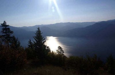
This hike begins on U.S. Forest Service Trail 230 and then merges with a forest road, offering one of the best views of Lake Pend Oreille possible from the ground. From the north side on a clear day, vantage points offer a view of about 30 miles of Lake Pend Oreille, framed by Three Sisters Peaks on the left, the Bitterroots to the right and the Cabinet Mountains in the distant north.
The interesting outcrops of rocks, which hang over the cliffs and spill from the hills, are reminders of the Ice Age floods of the region. With the prevailing south winds this time of year, the north side of Cape Horn is calm, but that changes quickly when one is exposed to the south face.
Vistas to the south are equally spectacular, with the imposing, goat-populated, Bernard Peak looming over Echo Bay and the town of Bayview. Glancing over the shimmering and very deep waters, the bay in front of Lakeview, the gateway for silver miners during the late 1800s, is in view. For a short time one of the largest settlements in the area, it is now mostly a ghost town and home to seasonal residents.
A plus in the fall is the array of colors from the changing foliage, along with wildlife on the move.
Directions: From I-90 and U.S. Highway 95, go north on U.S. 95 for 18.3 miles, then turn right on Highway 54 into Farragut Park. Follow Highway 54, which becomes Main Street and Perimeter Road in Bayview, for approximately 8.2 miles. Turn right on Cherokee Road and follow the winding mountain road for approximately 5.3 miles, bearing to the right at all major forks. At the trailhead, proceed on foot to Trail 230 for about 200 yards, then right onto the forest road.
Length: Approximately 3 miles round trip. Ties into Trail 230, which is 6.2 miles long.
Elevation: There is an elevation increase of approximately 2,000 feet from the start of Cherokee Road to Cape Horn peak at 4,200 feet.
Use: Light.
Trail condition: The wide logging road offers a good walking surface.
Difficulty: Easy.
Restrictions: Hikers should be extra cautious during the hunting season. Stick to the main trail and make enough noise that hunters will know you’re not fair game.
What to see: Wildlife (I spotted deer, turkeys, grouse and a hawk on my recent hike), forests and spectacular views of Lake Pend Oreille and mountains.
Special features: A geocache is hidden on the trail.
Preparation: Information about the area, including a trail guide for Trail 230, is available from the Sandpoint Ranger District, 1500 Highway 2, Suite 110, Sandpoint, ID 83864-9509, phone: (208) 263-5111. Visit the Idaho Panhandle National Forest Web site at www.fs.fed.us/outernet/ipnf. The ranger office suggests leaving your trip schedule with a responsible person. Detailed topographical maps are available for purchase from the following vendors in Coeur d’ Alene: Black Sheep Sporting Goods, The Yacht Club Sales and Service, and North Idaho Blueprint.
Gear: Good hiking boots or walking shoes are essential. Dressing for changing conditions and carrying drinking water and a first-aid kit are always good ideas. Wear bright clothing during the hunting season – hunter orange is best, but bright red or yellow also work. Other recommended accessories: map, compass or GPS and cell phone for emergency contact.
Note: Motorcyclists and ATV users are urged to slow down when approaching other trail users. Geocaches are found in a treasure hunt game, using clues from the Web site, www.geocaching.com.