Floating through the Breaks
If you’re a Lewis and Clark fan, there’s still a “trail” from which you can view the land pretty much as the Corps of Discovery saw it in 1805 and 1806.
It’s on the Missouri River which flows gently through the 375,000-acre Missouri Breaks National Monument in central Montana.
In late June, with five old college chums, I took my second float trip through the Breaks which are administered by the U.S. Department of the Interior’s Bureau of Land Management.
Here’s a sampling of our experience.
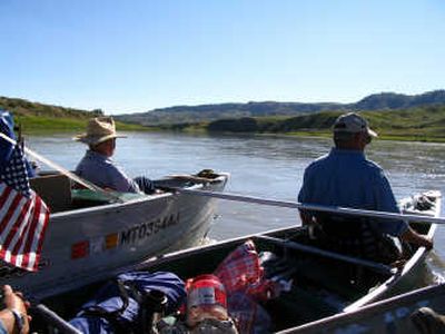
We put our pair of 13-foot and 17-foot motorboats plus a canoe into the brown water at Coal Banks Landing, about 30 miles northeast of Fort Benton and eight gravel road miles off U.S. Route 87.
Prior to our launch, we had positioned our two pickups with boat trailers at Judith Landing, 46 miles down river from our launch point. With a van, we hauled the drivers back to Coal Banks.
The area was named for an outcropping of bituminous coal on the banks above the river. Skippers of the steamboats that plied the Missouri’s waters in the 19th Century hoped that that coal would fuel their vessels, but it was too low grade.
So, until the end of the steamboat era in the late 1800s, “wood hawks” roamed the river basin, falling and hauling cottonwoods to the river’s banks to fuel the vessels.
Since then, the trees have returned and the landscape now is nearly identical to that sketched by a Swiss artist named Karl Bodmer in the 1830s.
A pair of BLM volunteer hosts welcomed us to Coal Banks, which is a campground in addition to a boat launch. A storm was brewing that evening, and winds eventually whipped through at 55 mph.
Because of the gale, they kindly invited us to share the government-issue trailer which was parked beside their motor home. One of our crew took them up on their offer, another slept in the back of the van, and four of us weighted down our tents with our bodies through the stormy night. By morning, the wind had abated, so we began our float.
The 41-mile stretch of river from Coal Banks to Judith Landing is the most spectacular on the Upper Missouri, and thus the most popular. But so far, the BLM isn’t controlling access by issuing permits. They do ask that you sign a boater’s register so, if you don’t return, the government will know you’re missing.
Anyway, permits weren’t necessary when we went, since we saw only a half-dozen other floaters during out three-day trip.
The government has designated this stretch of the Missouri as a “Wild and Scenic River.” Scenic it is; wild it is not. However, we did encounter rapids of a sort several times, but none of the white water variety.
One of our gang, Chuck Sundstrom from Alberton, Mont., is a Meriwether Lewis re-enactor, an authority on the Corps of Discovery and a veteran of 23 floats on this stretch of the river. He came equipped with a book that provided a mile-by-mile history, and thus was our official narrator.
For about half our trip, our three vessels were lashed together as we drifted with the current at a leisurely 3.5 mph and listened to his tales of times past.
About a mile down river from Coal Banks, we pulled out at Little Sandy, a camp with fire pits and a pit toilet. With Sundstrom leading, we climbed for 15 minutes to a hillside overlooking the river.
There he pointed out tepee rings, fire pits within several of them. He explained that Indians once camped here on the bluff, where a constant breeze keeps mosquitoes away. The rocks were placed to hold down the sides of their buffalo skin tepees.
Ten miles into our float we entered the “White Cliffs of the Missouri,” an area of stunning beauty. Lewis wrote a description of the bluffs that tower above the river, noting how water had shaped the limestone into “a thousand grotesque figures, pyramids and lofty freestone buildings … their parapets well stocked with statuary … so perfect indeed are those walls that I should have thought that nature had attempted here to rival the human art of masonry. …”
Homesteading laws in the late 19th and early 20th centuries encouraged settlement of unoccupied western lands. Hundreds of hardy men and women did their best to settle these lonely river bottomlands, but the environment was harsh, the land was isolated and unsuitable for farming, and drought and grasshoppers also took their toll.
Crumbling timbers and the occasional man-made rockpiles, once the walls of crude cabins, line the river corridor, testament to abandoned dreams.
We stopped to examine a few of the sites, including the stones remaining where horse rustler Jack Munro built a cabin of sandstone.
Another few hours took us to Lewis and Clark’s camp of May 31, 1805, which is now another BLM campground. The explorers called this site “Stone Wall Creek,” but it’s now known as Eagle Creek.
Towing their “pirogues” (boats) upstream, Clark writes, “their labour is incredibly painfull (sic) and great, yet those faithful fellows bear it without a murmur.
“The hills and river clifts (sic) which we passed today present a most romantic appearance. The bluffs of the river rise from a hight (sic) of from 2 to 300 feet and in most places nearly perpendicular. …
A half-hour hike into the hills behind the campground brought us into a canyon so narrow that one can reach out and touch both sides. It’s a place to avoid if there’s a threat of rain, for water could sluice through this declivity in a torrent.
After a night at the campground, primitive, we were off again, soon to pass Grand Natural Wall, a mile down river on the left. It was one of a dozen or so dikes, formed of hot magma that pushed its way into the sandstone, then cooled.
The igneous rock comprising it is resistant to erosion, and rain water has eroded the surrounding sandstone faster than the rock, resulting in the impressive vertical formation.
Five miles farther on the right we sailed past Citadel Rock. Clark noted that it was “a high steep black rock riseing (sic) from the waters (sic) edge.”
It was sketched by Bodmer, and its appearance today seems identical to what he saw in 1833.
About two miles farther is Hole in the Wall, a 20-foot gap in the rock high on our right as we headed down the river. When he passed it in May 1847, Jesuit missionary Father Nicholas Point characterized it as “Pierced Rock.”
Five miles farther, this time on the left and a half-mile from the river, was steamboat rock, best viewed from down river of the large sandstone formation where it takes the shape of the vessels for which it’s named.
Our camp that night was at Slaughter River, site of Lewis and Clark’s camps of May 29, 1805, when journeying upriver, and Lewis’s camp of July 29, 1806, during the Corps’ trip home.
Another BLM-designated primitive campsite, it has pit toilets, fire rings and a shelter which was being used by another party, leaving us to pitch our tents once more.
The explorers affixed the name to the camp because of a concentration of dead buffalo they found downriver. That led Lewis to believe they’d happened upon a buffalo jump, where Indians had hazed the bison over a cliff.
Archaeologists haven’t found a jump nearby, so the animals had presumably drowned in the Missouri.
The next morning, about a mile down the river, we pulled out at the junction of Arrow Creek and the Missouri to view a scene cross-river painted by Bodmer in 1833. Absent from our view were the 200 lodges of Gros Ventre Indians on the far shore that the artist had captured from this vantage point.
But other than that omission, we saw a scene identical to that sketched by the Swiss artist 174 years ago. The remains of a homesteader’s cabin made of notched cottonwood logs marks the spot.
About six miles below Arrow Creek we floated through Deadman Rapids which required only a few easy paddle strokes to keep our canoe pointed downstream.
Called “Ash Rapids” by Lewis and Clark for the trees growing in the area when they passed, the later more ominous name was appended some years later, allegedly for four men who died when their canoe capsized in the rapids.
We reached our takeout point, Judith Landing, late in the morning of our third day on the river.
Buffalo burgers, ice cream, brochures, a toilet and a Dumpster all got our attention before we loaded our boats and gear into the two waiting pickups, then began our drive back to Coal Banks where we’d left the van.
We’d be remiss if we didn’t mention wildlife. Throughout our voyage, flocks of pelicans kept us company. They’re probably relatively recent residents of this country, since Lewis and Clark mentioned seeing them only twice during their voyages through this part of the country.
None of us are skilled ornithologists, but we did spot both a bald and a golden eagle, the latter being chased by a flock of “LBJs” (little brown jobs) for some infraction of bird protocol.
We did see lots of cows, for this is summer graze country. But only as we approached Judith Landing did we sight anything resembling a modern ranching operation.
During our return to North Idaho we stopped in Fort Benton, founded in 1846 by the American Fur Co. at the head of navigation on the Missouri.
Proud residents have erected a series of interpretive signs along the main street which fronts the river, and just off the sidewalk is a keelboat built for the 1952 movie “The Big Sky” starring Kirk Douglas.
It’s home too to the BLM’s brand new Upper Missouri River Breaks Interpretive Center, where you can purchase books and maps that would guide you down the river.
If we do it over again, that will be our first stop.
Fort Benton also boasts the Museum of the Upper Missouri, an agricultural museum, the Hornaday Gallery of Western Art and Taxidermy, Homestead Village and the Grand Union Hotel, built in 1882, now a five-star lodging with associated restaurant and brew pub.
The town itself is worth a visit.