Blanket of white

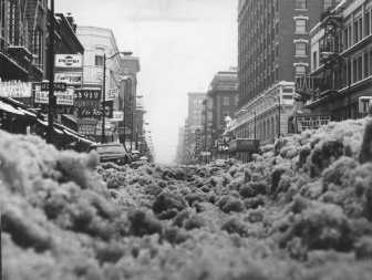
The 16-hour snowstorm that ended at midday Wednesday was the single-largest snowfall to cover the region in more than four years.
It broke the daily snowfall record for Jan. 8 in Spokane with 5.4 inches, and it was the deepest accumulation from a single storm since 8.2 inches fell on Nov. 20, 2003.
Roads were extra hazardous Wednesday morning. Shovelers’ arms and backs no doubt ached under their heavy loads.
But the first big dump of 2008 was modest by historical standards in the Inland Northwest.
Just about any conversation involving a big snowfall could trigger a recitation of winters that were worse. Old-timers will tell you about 1949-50 and 1968-69. While those were bad, other recent winters rank up there, too, including 1985, 1992-93 and 1996.
What made this week’s storm remarkable was how long it lasted. Trace amounts began falling before dawn Tuesday. The snow continued on and off until about noon Wednesday.
“It was a very long duration snow for us,” said Mike Fries, forecaster for the National Weather Service in Spokane.
A typical Inland Northwest snowfall lasts from four to eight hours, he said. “This was more than twice as long,” he said.
Across the region, snowfall accumulations were similar. Coeur d’Alene and Rathdrum had 6 inches while Spirit Lake had 8 inches. A few foot-depth amounts were reported, too, at Mount Spokane and northeast of Clayton.
Areas to the northeast were spared a bit. Sandpoint had 4.4 inches and Bonners Ferry 3.8 inches.
More snow was forecast for today, and a mix of rain or snow is expected into the weekend. Drier conditions could settle over the region early next week. Temperatures should climb to the mid-30s during daytime hours through Saturday.
Wednesday, it wasn’t just the depth that made the snow difficult. The 7.6 inches at Spokane International Airport contained 0.57 inches of water for a snow-to-water ratio of 13 to 1. The relatively “heavy” snow contributed to driving trouble and made clearing of streets and walkways more work than normal.
Even so, people who lived through the legendary winters of the 1950s and 1960s will tell you it can be much worse.
The record for a single-day snowfall in Spokane was 12.7 inches Jan. 21, 1954, in records going back to 1881. The most snow to fall in a single month came in January 1950 with 56.9 inches. And the deepest snowpack ever in Spokane came in February 1969 when 42 inches piled up on the ground.
Motorists that winter could not see over massive snow piles at intersections, so they attached stick flags to their cars to warn one another of their approaches.
The winter of 1992-93 may have been the biggest snow year in recent times with a total accumulation of 87.3 inches.
Wednesday’s snowfall still was enough to leave motorists and others with major challenges.
Meals on Wheels had difficulty delivering meals to seniors. Many of the volunteer drivers couldn’t run the routes because they couldn’t drive the trucks, said Mollie Dalpae, director of Meals on Wheels, which assists those 55 and older. “We called everyone we know who had four-wheel drives and trucks to help get the food out.”
Twice, the trucks delivering food to the nonprofit agency have been unable to make it over Snoqualmie Pass because of weather, Dalpae said. “We get a call in the early morning and have to prepare 500 frozen meals, which is great if (clients) have a microwave or ability to heat them up.
“We serve 100 seniors per day who come here,” Dalpae said. “We feed 500 seniors in their homes per week. We are also calling seniors to see if they need blankets.”
Homeless shelters in Coeur d’Alene were full Wednesday. Kathy Reed, St. Vincent de Paul social services director, said both the men’s shelter and the women’s and children’s crisis center were out of room.
St. Vincent is the largest homeless shelter in the Coeur d’Alene area.
A few spots were available at Spokane shelters, but the House of Charity has been full every night, Director Ed McCarron said.
Avista Utilities reported that about 1,281 customers were without power Wednesday morning after falling trees and debris fell into power lines. By 2 p.m., that number had been reduced to 10.
“The majority of the customers without power were in Coeur d’Alene, with about 228 in the Spokane area,” Avista spokeswoman Debbie Simock said.
Also, Kootenai Electric Cooperative had about 100 people without power. Those outages occurred in the Rockford Bay area of Lake Coeur d’Alene and in Harrison, said spokeswoman Erika Neff. Power was restored by 11:15 a.m.
The city of Spokane declared a “Condition Red” snow emergency, meaning city crews will plow around the clock until they can remove snow from 967 miles of streets, city spokeswoman Ann Deasy said.
Twenty-six Spokane city snowplows, three sanders and six de-icers were working Wednesday.
The crews focus first on snow emergency routes and major arterials, then secondary arterials, bus routes and residential hills.
If it snows this morning, city crews likely won’t reach residential streets until Saturday.
Spokane County, which has many more miles of road than the city, had 96 snowplows, road graders and sanders on the job, said Wayne Storey, operations and maintenance superintendent for the county road department. They started on arterials Wednesday night.
Once those were cleared, they planned to hit secondary arterials, such as Evergreen Road in Spokane Valley.
Next in priority for county crews are hillside streets, which they hope to hit today – barring more snow that would force them back to arterials.
Lowest priority are what Storey calls the flatland residential streets.
“Hopefully, we should finish (everything) sometime Monday or Sunday,” Storey said.
Coeur d’Alene crews hit the streets at 4 a.m. Wednesday and cleared all arterials, hills and emergency routes.
“We are already working on some residential streets,” streets Superintendent Tim Martin said. “We expect to have all streets cleared and ready for the next storm” by this morning.
The Lake City’s snow-removal plan calls for clearing all streets within 38 hours.
“We’ve been actually averaging 33 hours,” Martin said. “We are very proud of our snow removal. It’s kind of an attitude. We get after it.”