Winchester Wasteway a hot spot for spring paddling
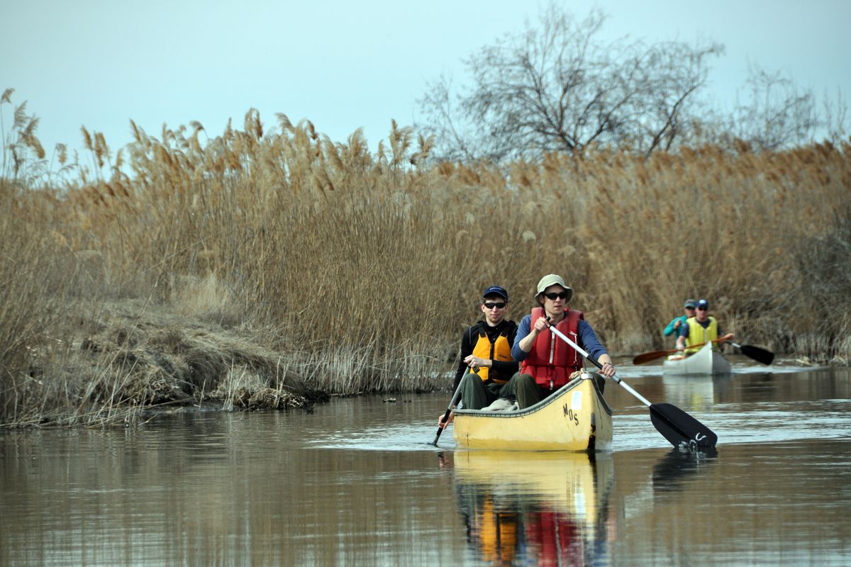
Camped on a sand dune, our paddling group was rousted by a haunting chorus of coyotes just outside the tent. I was thrilled to be lured out under the sprawl of stars, but not surprised. Song dogs have serenaded me on every canoe trip I’ve made over three decades along a unique waterway in the Central Washington desert. On this March evening, they were merely the closing act for the day’s earful of paddle strokes, the racheting calls of sandhill cranes and the trill of red-winged blackbirds.
This strangely wet portion of the arid Columbia Basin southwest of Moses Lake had treated us to a riot of flushing mallards, honking geese and the pat-a-pat of coots running on the water as we passed.
When a beaver slapped its tail as a warning, everything shut up briefly as though a stern teacher had clapped her hands.
We didn’t see another human during the day. That much, at least, you might expect on a water route named the Winchester Wasteway.
Indeed, it’s an afterthought that canoes can find their way for a couple of days toward the roar of a waterfall smack dab in the middle of the desert.
The promise of recreational fishing, boating and camping was a carrot dangled before the public by Columbia Basin Reclamation Project designers. But it’s not clear than even the promoters had recognized they would be creating a paddler’s dream trip.
Lake Roosevelt, formed in 1942 by the completion of Grand Coulee Dam, would provide Columbia River water to be pumped uphill into Banks Lake, built in the early ’50s. From there, canals would deliver the water to help make the basin’s arid land bloom with crops.
The topography for flowing water was already in place, carved by post-Ice Age floods. But the Winchester Wasteway did not emerge as a stream through the desert in modern times until water was spread over croplands that had been mostly sage, sand and cactus for thousands of years.
Seep lakes developed in the once-parched landscape, attracting waterfowl and other wildlife while irrigation runoff was routed into a natural channel en route to Potholes Reservoir, forming one of the most wonderfully obscure paddling adventures in the West.
Spring is a magical time on the wasteway.
Nesting waterfowl make a racket day and night. Green sprouts from the brown along the banks. Leaves burst from buds.
Marsh wrens put finishing touches on their nests before the new growth of cattails and bulrushes obscures them from sight. Muskrats shimmy along the shoreline and the number of beaver lodges indicates a robust population.
The Washington Department of Fish and Wildlife tries to manage the vegetation that explodes from the combination of heat and water.
Small controlled burns along the wasteway spur generation of wildlife-friendly plants and consume biomass that can clog the channel.
Ducks Unlimited helped engineer a waterfowl wetlands project nearby.
WDFW and the U.S. Bureau of Reclamation introduced beetles in 1991 as a biological method of controlling a smothering infestation of purple loosestrife. After a slow start, the beetles took hold around 1998 and kicked butt on the noxious weed.
But no such biological agent is approved for dealing with the towering plumes of non-native reed grass called phragmites, which invades the area and threatens to choke the wasteway and Potholes Reservoir.
Although pleasant to the eye at some stages, the phragmites has been sprayed with herbicide in recent years to keep water moving through the wasteway.
The spraying is a boon to critters, which find little useful habitat in thick reed grass. It’s also a boost to paddlers and waterfowl hunters who negotiate the waterway’s maze of channels.
Late March and early April are prime time for paddling the wasteway, at the possible price of frost on the canoe seats first thing in the morning.
Water is just getting warm enough in the off-channel sloughs to produce good fishing for bass. Mud clouds boiling from the silty bottom in the wasteway’s wide spots indicate it’s time to rig a rod and try saltflats-type casting for carp.
By June, the heat begins to brown the landscape, but the wasteway keeps flowing, boosted by irrigation to Columbia Basin crops.
Canoe campers recognize the source of their adventure by packing containers of fresh water from home.
The wasteway can be paddled year-round, although the flow from late-October through November can be twice as high as it is in March and April. Waterfowl hunters build blinds and set up decoys along the wasteway from mid-October into December, when the sloughs can be ice-capped.
A sense of humor is more useful than a map and compass for navigation in the wasteway. Paddlers may hit wide spots and dead ends in the dunes and have to backtrack to find the channel. A few miles later, the channel may be narrow and paddlers may have to draw-stroke vigorously to pivot the canoe into a 90-degree turn.
Vegetation can obscure the channel in some places. Locals at the put-in advised us: “When in doubt (at a confusing junction of channels), go right.”
That worked out, most of the time.
On a couple of occasions, we would stir mud with a paddle or watch for weeds bending downstream to track the channel current when the route seemed to dead-end in a slough.
Depending on the weather, high rubber boots can be a better choice than sandals for the inevitable wade through shallows or cattails.
The wasteway downstream from Dodson Road flows through state-managed land. Sand dunes provide primitive campsites.
Avoid the tougher paddling section of the wasteway by taking out at the gauging station at roughly the midpoint of a 25-mile route from Dodson Road to the take-outs at Potholes State Park or MarDon Resort.
The lazy nature of the wasteway changes near the gauging station.
When a paddling partner yells, “Duck!” in this stretch, he may not be referring to waterfowl.
Russian olive trees grow tighter to the wasteway here and thorn-spiked branches hang over the water.
The paddler in the bow can avoid them with prayer and a deft draw. The paddler in the stern might put more stock in armor.
The channel changes from sand to rock cobble and gets faster, narrower and more serpentine in the last leg to Potholes Reservoir.
Then there’s the waterfall.
Downstream from the gauge, paddlers must listen for the roar of the falls and watch for the tramped-down portage route. Go too far and the channel becomes even swifter, rockier and less pleasant for getting a canoe out of the water for the 100-yard haul.
The water gushes over concrete-like caliche cliffs in a two-stage fall that roars down to its final 10-foot plunge into a deep bowl.
Paddlers drag their canoes down a sand dune on the portage.
From the falls, a flatwater maze of willow-studded dune islands must be negotiated out to the main body of Potholes Reservoir.
Fishing boats help paddlers reacquaint with civilization. The route heads northeast at first, then southeast into the reservoir, skirting the outside of the brushiest dunes toward the tall poplars of Potholes State Park.
Only experienced paddlers should attempt this 3-mile open-water stretch in foul weather. The reservoir can be windy, but some protection can be found by snugging to the lee along the west shore.
The trip for our group of six ended on the high note of mirror-flat water along Potholes and a vow to return to hear the coyotes another time.