Trails and fish flourished in aftermath of 1910 fires
It’s no coincidence that today’s choice hiking trails traverse mountains charred by the 1910 fires.
For better or worse, the explosion of flame across the region’s landscape 100 years ago this week sparked a new emphasis on forest fire suppression and prevention.
“When you look at the maps and where the lookouts and the first ranger stations were sited, you can see that our trail network was heavily, heavily influenced by connecting those dots,” said Doug Gober, Clearwater National Forest North Fork District ranger in Orofino.
“Out trail system would probably be a fraction of what it is had our fire management not been influenced by the 1910 fires – and the other big fires that came after that.”
A hiker with a yen to walk back into the history of the 1910 fires has thousands of miles of options that lead through the formerly scorched earth.
A few stand out, such as:
• Siamese Lakes - Straight Creek loop – a rugged 25-mile route from Clearwater Crossing southwest of the Fish Creek exit off Interstate 90 west of Alberton, and up through ancient cedars and hemlocks that survived the Great Blowup. The route tops out at cirque lakes at the Bitterroot Divide and heads down through a drainage that was devoured and dramatically transformed by the holocaust.
• Stateline Trail – follows the Bitterroot Divide on the Montana-Idaho border roughly 70 miles on maintained and unmaintained routes used by Native Americans and trappers because it was relatively open compared with the steep, dark canyons below.
The 1910 fires stormed over the divide, as one can see in choice segments of Trail 738, such as the 8-mile route from Hoodoo Pass (south from Superior on the Trout Creek Road) to Goose Lake.
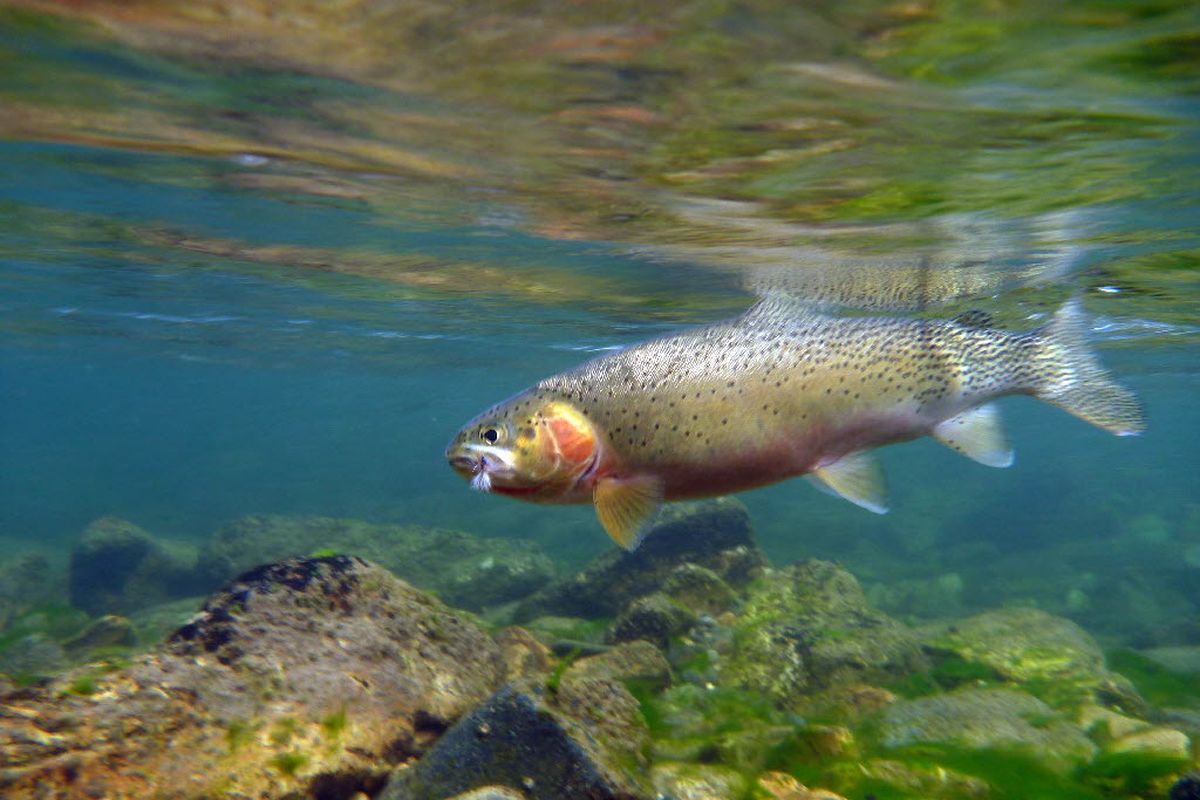
• St. Joe River Trails – including routes that can be linked into a rugged 38-mile trip through 1910 fires history. The river is a case study in the remarkable evolution of forest, wildlife and native fisheries restoring themselves from the ashes into one of Idaho’s premier fishing drainages.
An eye-opening trek traverses the roadless region of the upper St. Joe River, which I re-explored recently with David Moershel of Spokane.
From Interstate 90 at Superior, Mont., drive south on Cedar Creek Road (Forest Road 320) about 28 miles to Cascade Pass on the Montana-Idaho border.
This rough, narrow road can be an adenture in itself.
“I’ve towed vehicles from every corner on this road in my 21 years here,” said Carl Metcalf of Carl’s Towing during our $300 chauffeured detour back to Superior after we’d suffered two flat tires simultaneously.
Later, finally arriving at Cascade Pass, we started hiking at 6,500 feet, heading southeast on Stateline Trail 738 on the Bitterroot Divide between Montana and Idaho.
Indeed, several other states are involved in this alpine trek as it drifts above timberline, passing Oregon Lakes (California Creek isn’t far away) and leading six miles to Illinois Peak, elev. 7,690 feet, the highest named peak on the Idaho Panhandle.
Blooming pink mountain heather was breathtaking against the succession of rounded peaks and valleys fading away in the distance in every direction.
Other flowers brightened the highline route through meadows and crags, including columbines, penstemons, yellow pasqueflowers, bluebells, gentian, phlox and beargrass.
From Illinois Peak, one can head directly down to primitive campsites at St. Joe Lake, the official source of the St. Joe River, nearly 135 river miles from the river’s terminus at Lake Coeur d’Alene.
But a short detour leads to the more specific source of the river: a small, shallow spring-fed tarn on a grassy bench above the lake.
Here an angler can anoint himself in the St. Joe’s holy waters with one foot among the purple shooting stars on each side of the clear stream as it tumbles down to the lake.
Hatchery trout stocked by aircraft in St. Joe Lake will satisfy the itch in a casting arm, but the best is yet to come.
The river begins at 6,400 feet, flowing from the lake and plunging down Rambikur Falls.
In August, a hiker following the river on Trail 49 usually can hop rocks to ford the St. Joe in the next 5.5 miles to the Medicine Creek trailhead.
The trail had been brushed and maintained in mid July for the first time in several years, making it a breeze to get farther downstream to the promise of serious fishing.
From Medicine Creek to Heller Creek Campground the river is roughly paralleled for 5 miles by Forest Road 320, which descends from Cascade Pass and eventually leads all to the way on a notoriously rough route to Red Ives and the paved-road portion of the St. Joe.
The river is small above Heller by August, but it has fishable stretches few people bushwhack down to explore.
From Heller Campground, a remote camp graced with a single vault toilet, hikers can launch into the longest roadless section of the Joe.
From here it’s nearly 18 miles to the lower trailhead at Spruce Tree Campground, where we had our pickup shuttled.
The mileage is considerably longer if you chose to mingle with the mosquitoes, biting flies and no-see-ums to pursue the St. Joe’s famous native westslope cutthroat trout.
We bushwhacked down from the trail, over fresh elk tracks and ample piles of black bear scat, to fish prime waters. Then we’d return to our packs and inevitably find equal or better runs just a short way downstream.
We’d make camp and tote our wading boots back up or downstream to cover even more water during prime evening hours.
Headlamps were made for eating dinner after sundown on a trout stream.
Every run was different, but we always caught fish. Cutthroats evolved in these clear, nutrient-poor mountain waters by eating virtually every bug that comes by. With certain exceptions, they are usually more-than-willing during summer to rise to a fly pattern drifted drag-free above the olive green water where their camouflage avoids detection.
The middle portion of the St. Joe roadless area is lightly used, with virtually no campsites in the stretch from above Aqua Creek down to Bean Creek, where a crew of 25 firefighters retreated and hunkered in the water to survive a 1910 fires blowup.
The camping is pleasant at Bean Creek now, and even better if you have time to fish.
As if to endorse the clean water and wildness of this stretch, a hen harlequin duck flushed as Moershel approached a pool. Harelquins winter in the saltwater of the Washington Coast before migrating inland to nest in a few selected pristine mountain streams.
I was downstream tying a Renegade pattern onto my tippet and quickly realized the hen hadn’t seen me. I lifted my hand so she could fly under the tip of my 9-foot rod, the white patches on the side of her head giving away her identity.
Just downstream, fresh wolf tracks were sharply outlined in the shoreline mud.
We began seeing a few hikers in the lower half of the roadless area, some lured by the high-mountain fishing at Forage and Halo lakes on the trail looping Bean and Bacon creeks.
The human activity and horse traffic picked up near St. Joe Lodge, which is 5 miles upstream from Spruce Tree Campground.
But no tents were pitched at the first campsite a hiker would encounter coming the other direction 3 miles upstream from Spruce Tree. We saw only a couple of anglers.
Moershel and I had experienced a dramatic transition in four days as we ended our journey at the campground, elevation 3,800 feet, where families were splashing in the river to cool off.
We’d hiked from where the huckleberries were still green to where they were ripe for eating.
We’d descended from the pristine alpine ridges that had little fuel to offer to the 1910 fires down to the lodgepole pines that reforested large areas of the great burn.
Lodgepoles have a lifecycle of roughly 100 years, and perhaps that’s why they’re beginning to succumb lower in the drainage to pine beetles in a landscape that’s trending from green to red.
And, in another temporary respite in the grand scope of the St. Joe, Moershel and I had fully satiated our desire to catch and release cutthroat trout.
We scoped out the few anglers we saw fishing the popular waters along the river’s paved-road section as we drove out. Neither of us had to fight back a single twinge of inclination to stop and make a cast.
We had arrived.