By popular demand, the Smith is the most restricted recreational river in Montana
Swollen rivers choked with silt were raging throughout much of the Inland Northwest in recent weeks, prompting fishermen to be judicious about launching rafts or drift boats – at least until the water cleared enough for trout to see their lures.
But anglers with assigned dates to float central Montana’s Smith River had to go with the flow.
“Looks like this might be more of a scenic float than a fishing trip,” said Everett Coulter of Spokane after launching on Father’s Day for a four-day excursion.
He wasn’t complaining. Just drifting down the river is among Montana’s preeminent outdoor experiences, according to the state Fish, Wildlife and Parks Department website.
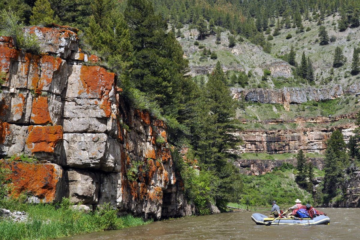
The river’s signature limestone outcroppings gradually pick up stature and height as visitors slip downstream. The buff-colored rocks are stained with hues of brown, red, and yellow and sprout a garden of plants and mosses.
Coulter had beaten the 7-to-1 odds of drawing a group permit to float the 59-mile picturesque canyon between White Sulphur Springs and Ulm.
When the permit arrived in February there was no way to know that the floating dates he’d selected would be greeted with flows around 1,800 cubic feet per second – erasing gravel bars, flooding the shoreline grass with the color of creamed coffee and rushing at a runner’s pace toward the river’s confluence with the Missouri.
When he had a chance to raft the Smith River a few years ago during the same week in June, the flows were around 230 cfs and his group of family and friends had to drag rafts over rocks in a few places.
But launch dates on the Smith – Montana’s only river with a lottery permit system for access – are set in stone.
No postponements are allowed because of weather or whatever. Indeed, unless the flows are trickling below 100 cfs, people who don’t show up for a scheduled launch without calling in a formal cancellation are barred from applying for a permit the next year.
Yet this is one place in Montana where few people complain about government regulation.
Surveys indicate that only 18 percent of Smith River floaters are not satisfied with the experience.
“It used to be a lot different,” said Dave Demmons, a former Montana river fishing guide who’s logged more than 70 trips on the Smith in the past 35 years.
Recreation on the river has been documented back to the 1950s, but the double feature of great scenery and fishing prompted visitation to mushroom in the 1980s.
The season before the permit system was enacted 18 years ago, “you had to be up and ready by 7 a.m. to get in line to launch,” he said.
“Then you had to get off the river around noon, just about the time the fishing was getting good, to get a good campsite.
“We counted 67 boats on the river one day and there was trash everywhere. On the last day, you’d get up at 6 a.m. and beat it to the take-out. Otherwise you might wait three hours to pull out of the crowd.”
Under the permit system, no more than nine launches are allowed each day. Groups are assigned to one of 52 designated campsites each night in the permit stretch, leaving no reason to rush past a good fishing hole or wildlife photo op to secure a camp.
The restrictions help preserve the world-class fishery and allow for long floats in relative solitude.
New this year, pets are prohibited on the river. “People were complaining about dogs straying into other camps and especially about the messes they leave at campsites,” said Bruce Auchly, MFWP spokesman in Great Falls.
Respect for the Smith River corridor has flourished. Litter is a blight of the past. Demand is up.
A record 5,823 applicants vied for group permits in the 2008 lottery drawing, up from 216 applications in 1993 when the permit system was enacted.
Nearly 600 groups and 5,000 people a year float the river primarily in the April-July period when there’s sufficient flow. They pay more than $150,000 in floater fees that are pumped back into improvements to campsites and river oversight, including weed control.
Anglers who don’t have the skill or equipment to organize private trips and secure permits pay around $3,700 a person for a five-day guided fishing trip down the Smith.
Even in a weak economy, the best of the outfitters have been booked full this season.
The Smith is unique in several ways.
Public access to the river corridor is managed as a state park by the Montana Fish, Wildlife and Parks Department, yet 80 percent of the shoreline is privately owned by two seasonally occupied subdivisions, a few mansions with heli-pads, four large working ranches, one guest ranch and one hunting lodge.
The Lewis and Clark National Forest manages 22 miles of shoreline on the eastern bank and the Helena National Forest has 5 miles on the western bank. A total of 28 camps are on national forest land.
The state leases land from private owners for public access to about five campsites.
About 20 private roads provide access to the Smith River in the canyon section, but the only public access is at the Camp Baker put-in at the south end of the 59-mile permit stretch and the Eden Bridge downstream at the north end.
Several Forest Service trails lead to the river, but no trail follows along the stream for through-hiking.
Floaters are getting hints about the next possible restrictions. River managers are asking permit holders to voluntarily reduce group sizes that have been trending up toward the maximum of 15.
River managers recommend no more than eight.
MFWP also is recommending that floating groups begin packing out their human waste, as already required on most popular float-camping rivers in the West, such as the Selway, Salmon and John Day.
Smith River rangers dig about 40 new pit latrines a year.
At Camp Baker, a river ranger gives floaters an orientation before they launch and issues a river map for each boat.
All designated campsites are well-signed, but wind and low river flows can frustrate floaters trying to reach designated sites if they plan days that are too long for conditions.
The river maps do not point out the 68 or so documented prehistoric American Indian archeological sites in the river corridor, although a well-worn trail leads to pictographs that likely were created more than 1,000 years ago.
Rangers give advice on possible hazards, such as blowdown cottonwoods in the lower stretch where the river breaks out of the canyon and into the prairie.
But ultimately floaters are on their own for 59 miles and three or four nights once they launch.
Through the serpentine corridor, the Smith sometimes makes sharp turns against the cliffs casting an illusion that the river dead-ends into rock walls.
Floaters have to pour muscle into their oars and paddles on these tight bends, although none of the permit stretch is rated higher than Class 2 in difficulty.
“It’s just the little Smith, but you have to respect it,” said the Camp Baker ranger after hearing that one group’s trip came to a sudden early end on Father’s Day morning, months after they had secured one of the coveted river permits.
“Sounds like a case of inexperienced rafters in a poor-quality raft,” he said. “They rammed a rock, ripped their boat. They were only on the river less than an hour.”