Winds fan fires, knock out power
Warmer, calmer weather expected for weekend
A dry cold front – strong by July standards – raked the Inland Northwest on Monday, causing numerous power outages and giving firefighters fits.
At least two accidents attributed to reduced visibility from blowing dust were reported in the Columbia Basin area west and southwest of Spokane.
The storm brought a marked change from a four-day heat wave that saw highs reach the low 90s.
It was the fourth major wind event in the region in recent months, following storms March 29, April 8 and the strongest on May 3 with a 59 mph peak wind.
National Weather Service forecasters said calm and warm summer weather will return after a relatively cool day in the lower 70s today.
“If you have outdoor activities planned, it looks like a pretty pleasant week ahead,” said John Livingston, meteorologist for the weather service in Spokane.
Highs should return to the 80s by Wednesday.
Winds gusted to 48 mph about 3 p.m. Monday afternoon at Spokane International Airport and triggered a round of outages.
An earlier gust reached 44 mph.
The wind whipped up a dusty haze.
Afternoon outages involved 2,800 customers in northeast Spokane, 2,200 customers in Colville and 380 in Spokane Valley. Elsewhere, outages affected 600 customers in St. Maries and 269 customers in Othello. Several outages involving fewer than 100 customers each also were reported in the Spokane area.
A plume of dust was visible on satellite weather images Monday afternoon extending from Grant County eastward across Lincoln County.
Grant County emergency officials said zero visibility forced closure of Stratford Road near Stratford and County Road 20-NE east of Soap Lake. An accident occurred on County Road 20-NE as a result of the dust.
Another traffic accident was reported in Adams County south of Ritzville, where zero visibility was occurring along state Highway 261. The highway was closed due to blowing dust, the Washington State Patrol reported.
More moderate winds were occurring elsewhere in the Columbia Basin but not causing widespread visibility problems through much of the day.
Interstate 90 through the basin appeared to have good visibility based on traffic camera images from the Washington Department of Transportation.
The weather service had posted advisories and warnings for the windy conditions and heightened fire danger.
A fire was burning overnight along U.S. Highway 97A north of Wenatchee.
Livingston said some smoke from that fire may have been carried to the Spokane area with the wind.
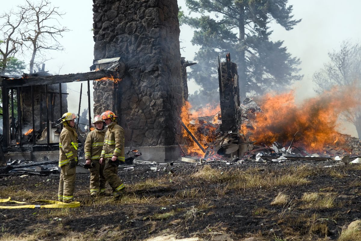
Cheney-area firefighters Monday afternoon fought a fire in a two-story home west of Salnave Road near the intersection of Malloy Prairie and Wood roads.
Firefighters reported that the fire was started when a falling tree hit a power line, triggering an electrical surge that ignited the home in Fire District No. 3. The fire then extended into a surrounding hayfield, which charred a couple of acres before being brought under control.
Spokane firefighters were called to a brush fire near Euclid Avenue and Havana Street.
A two-acre brush fire was burning in Coeur d’Alene at midafternoon.
Another fire was reported at an old lumber mill near the Clarkston Golf & Country Club in Asotin County in southeast Washington, according to the Lewiston Morning Tribune.
The Washington Department of Natural Resources announced a burn ban to protect state-protected lands through the summer. Fires will only be allowed in designated recreational fire pits. Gas or propane cooking devices are permitted.
The weather change repeats a springtime pattern in which strong low pressure systems develop off the coast of British Columbia and then move inland.
After a cool night in the upper 40s in Spokane tonight, warm weather returns Wednesday when highs go into the lower 80s and lows rebound into the middle 50s. Highs in the upper 80s are likely through the weekend.
Normal temperatures for today are 82 for a high and 54 for a low.