Zion, Bryce national parks boast stunning landscapes
Views as different as they are beautiful
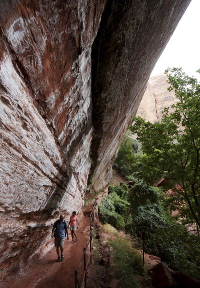

ZION NATIONAL PARK, Utah – The footfalls of hikers making their way through Zion and Bryce Canyon national parks are as different as the trails they take.
Some are silent; some echo. Some squish through calf-deep water. Others are dusty and tired.
Each park has dozens of trails to try, from easy, short hauls and relatively flat, mile-long loops, to hikes that go on for miles and hours with elevation verticals approaching 2,200 feet.
Both parks were formed millions of years ago when the Earth’s crust violently heaved, leaving behind stunning, unique arrays of rock formations. But the resulting landscapes are very different.
In Zion, massive sandstone slabs shoot skyward from the ground, thousands of feet in the air. In Bryce, the limestone has eroded over eons, leaving magical sculptures behind in reds, orange, brown and pink.
As a veteran hiker with dust-caked boots and a deep tan told me: “You have to look straight up at Zion, and straight down at Bryce Canyon.”
If you only have time for the highlights, each park has a marquee trail: Riverside Walk to The Narrows in Zion, and the Figure 8 Loop at Bryce.
A guided tour of Riverside Walk with a National Park Service ranger begins at a shuttle bus drop-off point at a formation called the Temple of Sinawava. The ranger explains Zion’s unique ecosystem and the role water played in forming the landscape as the tour meanders a mile to the Virgin River.
Here most tourists dip toes in the icy water and turn back. Those who continue must wade for several hours, stepping on slippery, perfectly round rocks in the riverbed that are impossible to see.
Serious hikers bring Neoprene booties, hiking poles and waterproof gear for their belongings. (You can rent gear at Zion Adventure Company in Springdale, Utah, just outside the south park entrance.)
After a few hundred yards slogging through the water, the depth inches up to midcalf and even hip-deep, and the pretenders are left behind.
Few hikers make the full two-hour trip to a point in the river called Wall Street, but that’s where you see how The Narrows got its name. The riverbed starts out 40 yards wide between steep 1,500- to 2,500-foot cliffs, but here it narrows to a claustrophobic 25 feet.
For even more adventurous treks, there are two choices. The complete Narrows Bottom-Up hike takes four to 10 hours, depending on your speed and how long you stop for pictures, with turnaround points at Big Springs or Veiled Falls to return you to the Riverside Walk starting point.
The other option is The Narrows Thru hike, a one-way, 10- to 12-hour trip which can mean overnight camping, requiring a National Park permit. It starts at Chamberlain’s Ranch and finishes at the Temple of Sinawava.
Other hikes worth considering at Zion include Emerald Pools, a three-mile, two-hour round trip to three sets of pools; a strenuous eight-mile, six-hour round trip hike called Observation Point with a summit overlook; and the park’s most popular backpacking route, West Rim Trail, which includes Angels Landing, Walters Wiggles and Scout Lookout.
From the West Rim, it’s 14.4 miles one way; from Telephone Canyon, 13 miles one way. Shuttle service is available.
The 3,302-foot elevation loss makes this the most dramatic trek in either park; it takes six to nine hours.
You can only drive in Zion if you’re staying at the park lodge, but the free shuttle bus service is convenient.
Bryce Canyon, 85 miles away, is more driver-friendly, with parking areas at various overlooks (though they can fill up at midday).
For early risers at Bryce, rewards include not only empty parking lots and trails, but also the morning light, great for photographs as the sunrise brings the canyon to life, illuminating the brilliant red and orange hues of the hoodoo towers.
You can experience this magical daily rebirth from several spots along the canyon’s top rim. Then the hiking can begin.
If solitude is your goal, beat the crowds with an early hike at Sunset Point. Narrow switchbacks will take you 1,755 feet straight down into a formation called Wall Street, which includes a frighteningly narrow passage into the heart of Bryce Amphitheater.
It’s a popular round-trip trek, so a morning start is a must to avoid the throngs of daytrippers later in the day.
At the bottom, trails go in every direction. Options include a counter-clockwise trek around the Navajo Loop and a quick loop back up to Thors Hammer (just over a mile back to Sunset Point), or the Queens-Navajo combination loop, a three-mile trip from the Navajo Loop to the Queens Garden Trail.
This second option requires a 1,785-foot climb back up to Sunrise Point, then a half-mile jaunt on the paved Rim Trail back to Sunset Point to finish. It’s considered a moderate hike, but the final climb up out of the canyon can be tough.
Add the Peekaboo Loop to the Navajo and Queens Trail Combination and the hike is almost six-and- a-half miles. It takes about five hours but shows off everything Bryce Canyon has to offer in a comprehensive and challenging hike.
For the best challenge in the park, consider the Figure 8 hike, starting and ending from Bryce Point, the park’s high point at 8,300 feet.
The one-mile hike down to the bottom of the canyon is a breathtaking 1,755-foot elevation drop to the floor. Once at the bottom, the Peekaboo Loop awaits, followed by the Queens Garden Trail, the Rim Trail and the Navajo Loop, and back to the other side of the Peekaboo Loop.
This is a serious hike of just over eight miles, taking about seven hours to complete. Solitude will be your reward, as relatively few hikers attempt the whole thing.
The trick here is to have enough left in your hiking tank to make the final one-mile hike back up the switchback trail to your car at the end.
Any of these treks can also be cut short, as shuttle buses stop at Bryce Point, Sunrise Point and Sunset Point to pick up tired hikers and deliver them back to the parking lots.
At Bryce, other options include Fairyland Loop, which starts and finishes at Fairyland Point. It’s the longest single loop hike in the canyon at eight miles, and has an elevation change of 2,300 feet.
One negative is that this trail takes hikers away from most of Bryce’s main attractions.
There are other ways to get around both parks besides walking. Since Zion restricts cars, cyclists are allowed to use the park road from Canyon Junction up to the Temple of Sinawava.
In Bryce, guided horseback rides are offered from stables near the lodge. If you’re hiking, you may encounter one of the horseback groups, with 10 to 15 riders. It can be unnerving to find an easy place to get out of their way; the lead rider can advise you.
Whatever trails you pick, when you’re done, pull off your boots and relax. You’ll be weary, dusty and maybe sunburned, but you’ll also be smiling with a sense of accomplishment.