Downed power lines, trees blocking roads
High winds knock out power to tens of thousands
Winds have been gusting to 59 mph at Spokane International Airport and 60 mph in Coeur d’Alene, causing power outages, downing trees and spreading debris.
Large power outages are being reported throughout the region, including Deer Park, Colville, Sandpoint, Lewiston and Deary, Idaho. Avista Utilities reported about 18,000 customers without electricity about 2:20 p.m., but the number started to drop by 3 p.m. as services were being restored. About 10,000 customers remained affected as of 6 p.m.
“The crews are working as quickly and safely as possible and will continue to work as long as conditions are safe,” said Avista spokesman Hugh Imhof.
An hour later, Inland Power and Light Co. reported that 4,200 of its customers were without power, and contract crews were brought in to help make repairs. That number had dropped to 3,177 as of 4:30 p.m., including 1,180 in Hoodoo and 815 in Green Bluff.
A high wind warning is in effect for most of the Inland Northwest for sustained winds this afternoon of 30 to 45 mph and gusts as high 60 mph until 11 p.m.
In addition, a dust warning is in effect for the Spokane area also until 11 p.m.
Forecasters said the peak of the storm should pass by 5 p.m.
Today’s storm is the third big wind event this spring. Storms on March 29 and April 8 were severe, but Monday’s storm had higher wind gusts and more outages. The previous storms brought peak gusts of 54 and 53 mph and outages of several thousand customers in each storm.
Downed power lines and trees are blocking streets throughout Spokane.
Avista said 1,550 customers were without power in the Colville area, 300 were out in Sandpoint, 2,400 in the Lewiston area and 500 in Deer Park.
“They have their hands full, that’s for sure,” said forecaster Jon Fox.
An outage affecting 1,400 connections in the Deer Park area was reported by Inland Power at 10:45 a.m. Nearly all of those customers had power restored by 4:30 p.m..
Nearly 400 Hauser Lake customers lost power after 11 a.m.
As of 4:45 p.m., about 500 Kootenai Electric Cooperative members were without power in the Hayden, Rockford Bay, Harrison and Athol areas.
The city of Spokane issued a press release to remind motorists that when they encounter a darkened traffic light to treat the intersection like a four-way stop.
Downed trees and power lines were causing street closures, including Argonne Road near Maringo and Upriver drives about 3:15 p.m.
Wellesley Avenue east of McDonald Road was closed about the same time.
Bernard Street between 34th and 36th avenues was expected to reopen by about 4:45 p.m., according to a spokeswoman for the city of Spokane. Southeast Boulevard between 18th Avenue and Rockwood was expected to be closed through the evening commute. The road was also closed from Perry Street to Rockwood Boulevard.
Southbound lanes of Washington Street near Riverfront Park were closed temporarily about 2:30 p.m. because of a downed tree and have reopened.
At Riverfront Park in Spokane, the SkyRide over the Spokane Falls was shut down due to high winds.
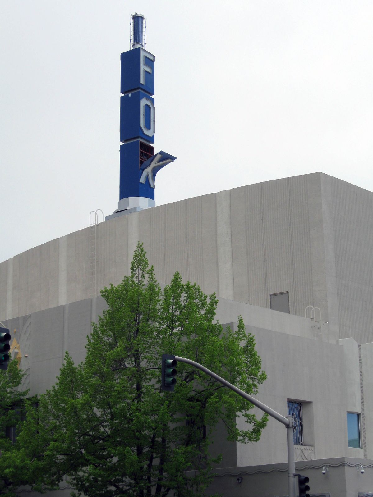
The vertical sign above the Martin Woldson Theater at the Fox had an “X” torn away from its mounting.
Blowing dust may also become a problem in some locations. High profile vehicles may have problems with the wind.
The Washington State Patrol reported an injury accident on state Highway 21 just north of Interstate 90, which was blocking the highway at 2:07 p.m. Details were not available. Visibility was poor at the time due to blowing dust.
A press release from Grant County’s Department of Emergency Management said that the storm was causing visibility problems, accidents and several road closures.
Traffic cameras for the Washington Department of Transportation showed a brownish haze of dust in the air along Interstate 90 at the Dodson Road interchange east of Moses Lake.
Forecasters also said the winds could cause roof damage and flying debris.
The wind storms should subside overnight, forecasters said.
A strong cold front that is passing through the region this morning is expected to create a strong air-pressure gradient from west to east as a low associated with the front draws air from a high pressure system off the Oregon coast.
Highs today will only reach the lower to middle 50s.
Colder weather settling into the region behind the front will lower snow levels in the mountains to 3,000 feet tonight and raise the risk of a frost tonight when lows in Spokane are predicted to drop to 32 degrees.
Snow showers are possible on Tuesday and Wednesday, especially in the mountains of the region.
Below normal temperatures and chances for showers are expected through Thursday night.