Weakening Hurricane Earl hits N.C.
Storm on wane as it moves up East Coast
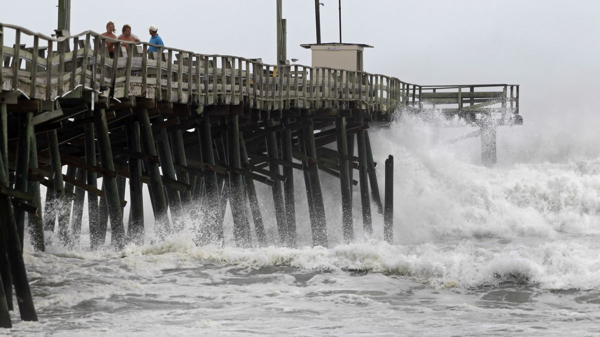
DURHAM, N.C. – A weakened Hurricane Earl brushed past North Carolina’s fragile Outer Banks Thursday night with stiff winds and high waves as it struck a glancing blow before spinning offshore up the Eastern Seaboard.
If the storm stays on its projected path, it could bring storm surges and spot flooding from Virginia north to Cape Cod today and Saturday. But forecasters said Earl would continue to weaken and stay out to sea before skirting the Massachusetts coast Saturday as a Category 1 storm with sustained winds below 95 mph.
Forecasters predicted that the storm would graze the Virginia coast this morning, then blow past beaches in Delaware, New Jersey and Long Island while remaining out to sea. Earl was not expected to make landfall anywhere along the East Coast before breaking up farther north over the Labor Day weekend.
Even as the storm weakened, the National Weather Service warned residents of Long Island, Cape Cod and Massachusetts to prepare for sudden wind gusts of up to 100 mph that could topple trees and cut power lines. A storm surge of 2 to 4 feet was predicted for the Massachusetts coast, along with 2 to 4 inches of rain.
“This is the strongest hurricane to threaten the Northeast and New England since Hurricane Bob in 1991,” Dennis Feltgen, a meteorologist with the National Hurricane Center, told the Associated Press.
As Earl approached, North Carolina authorities ordered the evacuation of most of the Outer Banks, a thin ribbon of barrier islands prone to flooding and beach erosion even during ordinary rainstorms. As night fell, rough surf and swirling sand threatened low-lying roads as high tide approached.
“This is a serious storm,” North Carolina Gov. Beverly Perdue said Thursday, urging coastal residents and beach tourists to evacuate. “It isn’t something to mess around with.”
Earl was a Category 4 storm early Thursday, with sustained winds of 145 mph. But it weakened to a Category 3 later in the day, with maximum sustained winds of 115 mph.
At nightfall, Earl dropped to a strong Category 2, with maximum sustained winds below 110 mph.
The National Weather Service predicted a “dangerous storm surge” between 3 and 6 feet along the Outer Banks, threatening the low-lying islands and their exposed sand dunes. The forecast called for 2 to 4 inches of rain overnight, with wind gusts of 50 mph to 75 mph.
By 9:15 p.m. local time, not a drop of rain had fallen on Roanoke Island, three miles across the Roanoke Sound from Nags Head, N.C., said John Wilson, a lifelong resident. He said media coverage of the impending storm was overblown – “much ado about nearly nothing.”
The strongest wind gust on his wind gauge was 26 mph, he said. “If we get 45 mph wind gusts tonight, I’ll be shocked.”
Virtually all of the island’s roughly 7,000 permanent residents stayed put Thursday night, Wilson said, even as 170,000 vacationers obeyed evacuation orders along the Outer Banks. His 10-room hotel, the Roanoke Island Inn, emptied Thursday morning but filled back up later in the day with tourists evacuated from Nags Head across the sound.
Jamie Daniels, the mayor of Manteo, the main town on Roanoke Island, said he kept his deli and pizzeria open until the usual closing time of 9 p.m. as the rain and winds held off.
“The trees aren’t even moving,” he said at 9:30 p.m.
But Daniels also said he was concerned about surf overwash swamping roads and cutting new inlets on the Outer Banks early today.
Although the storm was weakening, forecasters said, its winds were being dispersed over a wider area.
“The storm won’t be as strong, but they spread out as they go north and the rain will be spreading from New England,” said Bill Read, director of the National Hurricane Center.