Thunderstorms bring winds, fire danger to region

A red-flag warning is in effect, posted by the National Weather Service today for the potential of new wild fires triggered by thunderstorms.
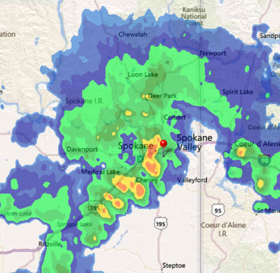
The warning went into effect at midnight and covers all of Eastern Washington and North Idaho. Thunderstorms awakened residents about 6 a.m. in Spokane.
Wetter thunderstorms arrived during the morning as expected and should help keep lightning fires from taking hold in wetter locations. Spokane International Airport had 0.11 inches of rain through 10 a.m.
Power outages were reported across the region. Avista Utilities reported that about 1,700 customers were without power shortly before noon.
The main line of thunderstorms has moved northeast of Spokane into far North Idaho, but forecasters said the risk of scattered thunderstorms will continue through the day.
Any smoke visible aloft today is likely coming from the Warm Springs fire in north-central Oregon, forecasters said.
Cooler air will fill into the region from the Pacific, dropping high temperatures from the 90s to the lower 80s today to the upper 70s through Thursday.
Spokane has not had a day in the 70s yet in August, but has had 12 days at 90 or warmer.
A forecasted low on Friday of 74 would be the coolest day since a high of 71 on July 23. The normal high today in Spokane is 82.