Peninsula’s Elwha River reborn as two dams fall

PORT ANGELES, Wash. – The unleashing of the Olympic Peninsula’s Elwha River from two dams presents Washingtonians with a not-to-be-missed opportunity to witness the transformation wrought by the world’s largest dam-removal project.
All along the river, a new landscape is unfolding.
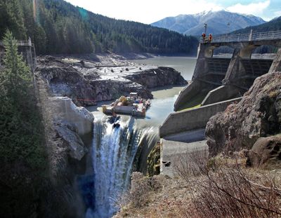
The Elwha Dam, built in 1910 about five miles from the river’s mouth, was removed by federal contractors last March. Glines Canyon Dam, the taller of the two – it used to be 210 feet high – was built 8.6 miles upriver from Elwha Dam in 1926. Contractors have it nearly out of the river; demolition should be finished by next May.
Both dams were built to power industrial development in Port Angeles. Neither provided fish passage, destroying the river’s legendary native salmon and steelhead runs.
Once the dams are out, fish are expected to vigorously recolonize the river, which tumbles 45 miles from the Olympic Mountains to the saltwater Strait of Juan de Fuca. With 83 percent of its watershed permanently protected within Olympic National Park, the Elwha presents one of the best chances for ecosystem restoration anywhere.
•
Andy Ritchie, restoration hydrologist for the National Park Service, joined me for a hike along the river this fall to see how the river was looking a year after contractors took their first whacks at Elwha Dam. A wonderland awaited us.
“This gives you some idea of how big these trees really were,” said Ritchie, climbing the sides of a giant cedar stump exposed as Lake Aldwell (formerly about 2.8 miles long and up to a quarter-mile wide) drained. The tree must have been a thousand years old when it was cut a century ago, before the reservoir was filled behind the dam.
As we walked along, Ritchie pointed out the dark, knotty roots of a sword fern exposed after all these years in the former lake bed. The roots had been preserved buried deep in the mud.
Everywhere, too, was the glory of the river: its sound, color and new life as it muscled through the soft sediment accumulated behind the dam.
A soft green haze of vegetation was already taking root in the newly exposed ground. Within 160 feet of the native forest, a rain of seeds had sprouted in thickets of cottonwood, willow, and lots and lots of horsetail.
Elsewhere on the former lake beds the National Park Service has embarked on an unprecedented replanting program, using seeds gathered from the Elwha watershed to grow dozens of varieties of native plants to crowd out weeds.
After our hike, we hopped in the car, turned onto Olympic Hot Springs Road and headed into Olympic National Park and upstream to Whiskey Bend Road, to find the Upper Lake Mills Trail for a look at what was formerly Lake Mills.
Not suitable for anyone with knee or back issues, this is a wickedly steep trail, gaining about 600 feet in less than half a mile. But it does get you to the riverbanks at the south end of the former lake.
If you’re up for the trail, it’s a very different experience to enjoy. The landscape is quite different, too, with large, gray cobbles layered on the beach.
To experience the whole restoration of the Elwha, I later drove west on Highway 112 to Place Road, turning right to park where it dead-ends at the water. I hiked down to the Elwha’s mouth, where the river empties into the Strait of Juan de Fuca. Great rafts of gulls bobbed on the lower river.
It was a peaceful place to reflect on all that has happened in this watershed, and all that is yet to come.