Dishman Hills trails makeover resisted by some hikers
An effort to rebalance wildlife’s share of the Dishman Hills Natural Area has been getting mixed reviews as workers try to scale back the web of unofficial trails.
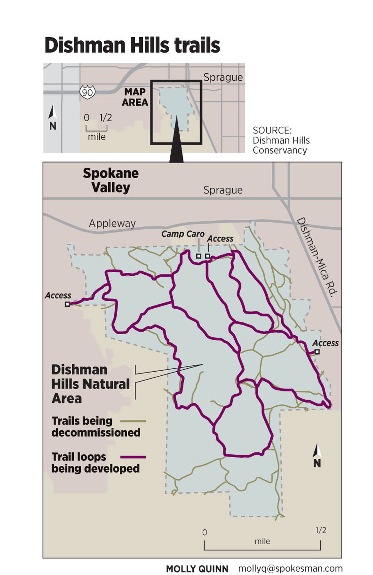
About 200 volunteers showed up April 21 to initiate a new plan, two years in the making, to decommission miles of trails that crisscross almost every niche of the jointly managed Spokane Valley nature preserve.
The Dishman Hills Conservancy recruited the muscle of the Gonzaga University men’s soccer team and other groups to cover unauthorized trails with logs, branches and other debris.
Handmade signs were posted to direct hikers onto new loop trails being created by the Spokane Mountaineers and Washington Trails Association.
But within a day, the work was being unraveled as anonymous people removed the debris and reopened some of the unauthorized trails.
The clandestine protest continued through last week.
“I wish they would talk to us so we could explain what’s going on,” said Paul Knowles, Spokane County Parks planner.
The 535-acre natural area south of Appleway and west of Dishman-Mica Road is managed by three landholders – the nonprofit conservancy, the county and the state Department of Natural Resources.

They cooperated to map the trail system and plan the revamping, activated this year after DNR committed $60,000 for new trail signs.
Established as a conservancy, the area has restrictions similar to those of national parks. Foraging for mushrooms or gathering other plants and even rocks is prohibited, said Knowles. Mountain bikes have not been permitted in the area. Dogs are allowed but they must be on leash.
Most of those rules are in the management plan but not posted. “When DNR finishes the new batch of signs, rules will be clearly listed at each trailhead access point,” Knowles said.
Brett Walker of the DNR said, “I expect that we’ll get the signs installed by the end of June.”
Installing the new signs before trail work began likely would have reduced the confusion, said Jeff Lambert, conservancy president.
“People not involved with the annual service day are not aware of what’s going on,” Knowles said. “So they see their favorite little trail or shortcut closed off and they get mad because they have no idea why.”
Knowles said the signs will play a huge role making this a success, although Karen Jurasin, a volunteer who helped plan the trails, notes that sign vandalism has been a problem in the past.
An area resident, who said in a Facebook post that he’s a regular conservancy visitor, complained that the plan closes trails on the northeast side of the Dishman Hills, where he often looks for transient camps as he hikes.
The man, who asked to remain anonymous, said transients will still access the area and will be less likely to be rousted out by the public.
Lambert said volunteers will try to educate the public about the advantages of the redesigned trail system of loops hikers can connect to make shorter or longer hikes.
“First, we’re re-routing trails that go onto private property,” he said. “Our neighbors like their privacy.”
Plus, “by closing some of the redundant routes, the trail system will be less confusing,” he said.
Said Knowles, “For a place so heavily used, the amount of emails, calls and comments received about people getting lost is astounding.”
“We worked with the loop trail concept, which is favored by hikers,” Walker said. “It’s the best way to lay out trails to make it easier for people to follow the signs.”
The re-routed trails have been planned to reduce erosion while leading hikers to some of the best places in the Dishman Hills, Lambert said.
“The Dishman Hills were purchased for preserving natural resources and wildlife habitats,” Knowles said. “Too many trails, combined with old fire breaks used as trails, were detracting from the user experience and giving wildlife no place to find any place where they won’t be disturbed.”