Lake Coeur d’Alene may reach highest level since 1997; St. Maries levee gets emergency help from the Army Corps of Engineers

The levee on the St. Joe River that protects the city of St. Maries is getting help from the U.S. Army Corps of Engineers.
Patricia Graesser, spokeswoman for the corps’ Seattle District, said the agency is working on securing about 300 feet of the landward side of the levee.
“It had gotten kind of scoured,” Graesser said.
The corps has a crew of 14 there working in shifts around the clock. It also distributed 5,000 sandbags in St. Maries and supplied a pump to mitigate flooding.
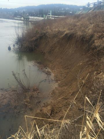
Idaho state Highway 5, which runs west from St. Maries through Heyburn State Park, has suffered severe erosion in places.
The Benewah County Sheriff’s Office said that stretch of road is closed to traffic for the winter, as is the access road to the state park, but there is substantial damage to the road.
Graesser said water levels at St. Maries are expected to go up for a bit, then drop.
Friday evening, the National Weather Service reported that Lake Coeur d’Alene could rise to minor flood level, the highest the lake has been since 1997, over the weekend.
High water levels mean that floating docks may be lifted and float away, and that large objects like logs and stumps may be dislodged from brush and snags along the shore.
The weather ervice advised those living along the Spokane River upstream from the Post Falls Dam to be aware of the rising water and ready to take precautions.
The Kootenai County Sheriff’s Office issued a warning to boaters late Friday, reminding them that during a threat of flooding most bodies of water within the Coeur d’Alene River drainage are automatically designated no-wake zones.
The designation changes when the gauge on the Coeur d’Alene River at Cataldo reads 43 feet or higher, or the gauge on the Coeur d’Alene River at Enaville reads 72 feet or higher. USGS reported nearly 72 feet at Enaville on Thursday.
Anticipating the higher water levels, Graesser said the corps has no plans of leaving St. Maries soon.
“We expect to be there at least over the weekend,” she said.