Landmarks: Tiny pier significant in mapping of region
Not far from the southeast corner of the Spokane County Courthouse sits a little pier made of white bricks, rather small as monuments go – but, as it turns out, significant to the exploration and mapping of the Northwest.
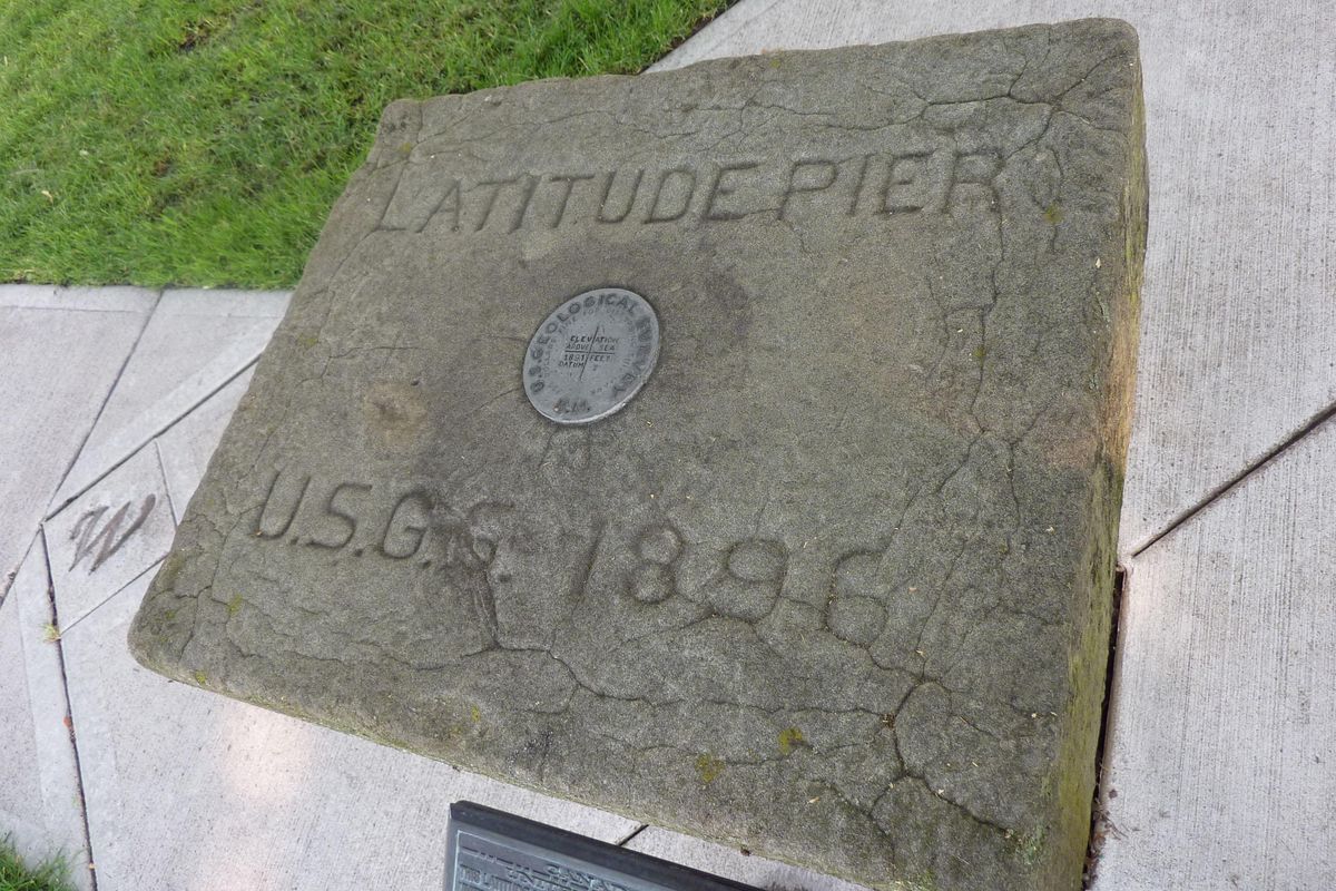
It’s called the Latitude Pier. It was originally put in place in 1896, and it soon became the starting point of a project to establish the precise border between Idaho and Montana along the 39th parallel. How all of that came to be is a long, scientifically detailed and rather adventurous story that involved several years and not insignificant danger from weather and terrain. But it all began with the little 3-foot-tall pier.
Technically it’s an astronomical pier. There had been an earlier pier established nearby in 1888, but when the courthouse was built practically on top of it in 1895, it was no longer usable for purposes of taking measurements using celestial observations. No evidence of that first pier remains today.
So 67.4 feet to the east of what had been named the Longitudinal Pier, the new pier was placed, with its latitude established by taking 59 observations on 27 sets of stars on different nights, according to U.S. Coast and Geodetic Survey (later the U.S Geological Survey) records. Back then it was open to celestial observation in all directions, but today it is shaded and blocked by a huge maple tree.
An 1897 USCGS contract called for identifying the 39th parallel, the (north-south) border between Idaho and Montana, and establishing where the (east-west) meridian intersects with it, from the Canadian border down to the crest of the Bitterroot Mountains – and installing monuments at approximately 1-mile intervals along the boundary.
The project took three years to complete, starting with the first triangulations with the stars at the pier in Spokane in order to get true positioning. Celestial observations continued from sites at Mount Baldy, Mica Peak and westward to Montana.
But why start in Spokane?
“Every crew chief decides on a point of beginning for a survey,” said Jim McLefresh, retired GPS survey technician for Spokane County. “Perhaps the Spokane site was chosen because it was open and flat or because the pier was already here. We just don’t know.”
The pier, topped with a huge stone in which is inlaid a metal USGS medallion and the 1896 date, served its purpose and has stood unused and mostly ignored for more than 100 years. McLefresh, whose office was in the Public Works Building, often walked by it and noticed how it had deteriorated over the years. He began researching the little monument and in 2008 set about trying to restore it, which meant rebuilding it.
He had hoped to wrap it into a 2009 project to restore the courthouse’s cupola and flagpole, but because the pier is owned by the USGS and not the county, permission and funding had to come from elsewhere. He got the permission, but funding was up to him.
Seeking white bricks that matched those on the courthouse, he and a master mason located a pallet of bricks off in a corner at the brickworks in Mica that were almost a perfect match. They only needed 88 bricks, but the whole pallet had to be purchased. Happily, it was offered at half-price for the project. Bricklayers Union Local No. 3 W-I-M paid the bill.
Throughout the project, numerous businesses and individuals donated time, talent and treasure for restoration of the monument, McLefresh said. When it was all done, he only had to pay $150 out of his own pocket.
Under the supervision of a master mason and licensed surveyors, the capstone was carefully removed and the original crumbling bricks taken down to 18 inches below ground level. When the new bricks were laid, jointing was carefully matched with courthouse masonry. The unused bricks from the pallet were donated to the courthouse, where some have been used in various repairs, according to McLefresh.
Precise measurements of the pier were taken by licensed surveyors during reconstruction, and when it was found that the bricks weren’t precisely where they were originally, they were taken apart … and construction began again. This happened three times.
The stone was set on top again, and the elevation was remeasured, revealing an elevation within a quarter-inch of what was initially measured in 1896, McLefresh said. A concrete pad and pathway had been poured, and McLefresh installed a brass plaque in front of the monument to outline briefly just what the pier means in the history of the Northwest.
It also meant something special to McLefresh. “I’m not sure why it was so important to me, but it was, and with a lot of help from a lot of other people who cared, we got this done,” said McLefresh, who retired in 2015.
When the courthouse improvements were dedicated in 2009, the little pier was included in the ceremony. Though most of the attention was on courthouse improvements, there was a small but devoted group of surveyors, masons and others in attendance who made sure the little Latitude Pier finally received the recognition it deserved.
NOTE: A relatively short but technical description of the Idaho-Montana boundary survey project appears in the 1900 Vol. XI issue of the National Geographic Magazine. Greater detail is available in the May 12, 1903, Bulletin No. 170 of the U.S. Geological Survey.