Getting There: Solving Regal Street’s problems would require digging deeper than the pavement
Regal Street has gotten the royal treatment lately. In the past two weeks, the city has done much-needed maintenance on the major road on Spokane’s South Hill.
The grind-and-overlay work between 29th and 39th avenues will deliver smooth pavement to commuters too familiar with ruts and potholes. When complete, it will be the third such project in southeast Spokane, joining already finished work on 29th between Freya and Havana streets, and on Freya between 29th and 37th.
In all, the city is focusing its grind-and-overlay work on eight areas in the city this year: Maple-Walnut streets between Fourth and Ninth avenues; Cowley Street from Seventh to Ninth; Wellesley Avenue from Nevada Street to Pittsburg Street; Indiana Avenue from Division Street to Monroe Street; and Hamilton Street from Trent Avenue to Desmet-Sharp.
The work is paid for with local funds generated by property taxes. Using taxes on land to pay for roads irks some people, but the two really should be more closely tied together. What happens on property can have a big impact on the transportation system around it.
Transportation and land use, in other words, should be thought of and planned together. The reason for this is on clear display on Regal.
Just look at any map or any photo from before 1960. Moran Prairie, as southeast Spokane is called in these old maps, is barely populated south of Lincoln Park. The city’s street grid barely ekes past 29th. Instead, the South Hill was, for the most part, wide-open farmland.
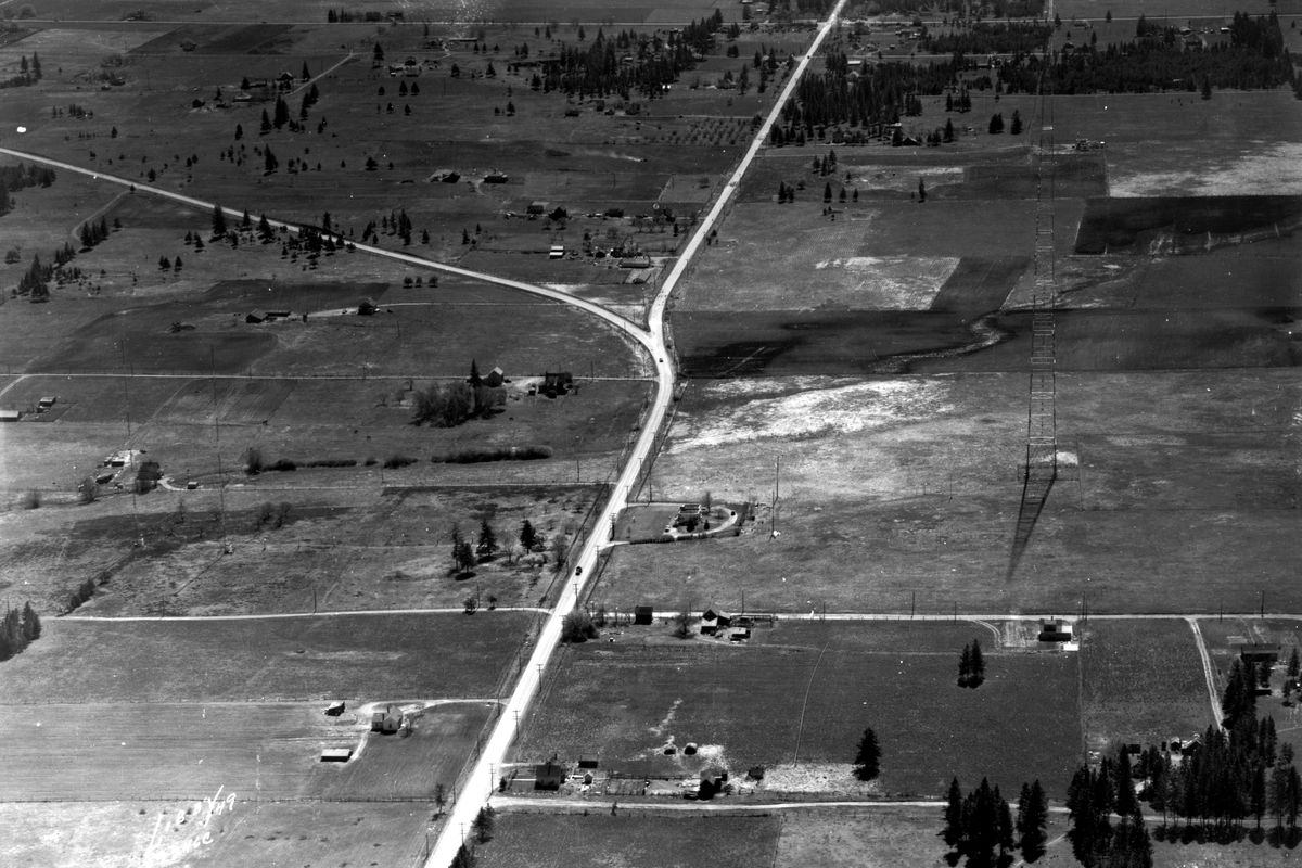
Aerial photos illustrate the situation in black and white. One photo from 1949 in the Northwest Museum of Arts and Culture archives shows the wiggly intersection of Regal Street and the Palouse Highway. A long-gone KHQ radio tower sits alone, with the infrequent house dotting the landscape here and there.
Now, the intersection has been rationalized into 90-degree angles; the Target shopping center dominates one corner. The tower and Art Deco transmitter building were demolished in 1961, replaced over time by the Adirondack Lodge Apartments, a retail complex with Twigs Bistro and Martini Bar, and the Educational Service District 101 conference center.
Another MAC photo from 1959 shows the future site of Ferris High School. Wide, plotted farmsteads rule the image, but already simple, boxy, mid-century American dwellings are creeping in, on streets without sidewalks.
Now, Regal is anything but a country lane. On average, the road carries between 10,000 and 20,000 vehicles a day. Commuters, students and shoppers have transformed it into a typical suburban arterial, complete with a Target and soccer fields.
While the slow, unremitting movement of a growing city changed Regal, its birth as an arterial can be traced to a specific hour. At 6 a.m. on March 11, 1963, the city christened the road as “major.” The designation came about when voters approved street improvements the year before. The money was originally to be used on Ray Street, which would’ve been widened and routed through the middle of the Ferris site.
For obvious reasons, the school board opposed that plan. Construction was underway; classes would begin Sept. 3, 1963. So engineers redesigned the South Hill arterial street plan, and the school paid $90,000 to move traffic from Ray to Regal. That’s how an arterial is born.
Years passed, the city grew, motorists proliferated and, in 1975, city engineers unveiled a plan to connect Southeast Boulevard to Regal via a “diagonal shortcut.” The federal government paid 80 percent of the project’s cost, allowing for the construction of the bypass and the strange intersection at Regal and 34th we still have today.
In 1990, the shift from exurban farmland to suburban neighborhoods was set in amber when ShopKo announced it was building a third Spokane location on Regal and 44th. Even then, The Spokesman-Review reported on the urban-rural interface, noting that a city planning official “said it was unlikely that a big store like ShopKo could be built on the parcel, which lies at the point where subdivisions begin to give way to farms.”
In 1994, growth on Spokane’s southeast side continued, and a study done by the Spokane Regional Transportation Council found that the South Hill roads were so congested that “quick fixes” were “no longer possible.”
“Without new roads, the southeast part of the city and its unincorporated fringe will get increasingly clogged as developments gobble up vacant land,” a June 1994 Spokesman article reported, noting that the study predicted double-digit percentage growth for both single-family homes and apartment complexes in the area.
By 1996, the paper called 29th and Regal “dysfunction junction,” saying, “Cars bound for the multitude of retail shops and services on every corner head in all directions, balling up at the intersection infamous among South Hill residents for delays and dysfunction.”
Still, despite warnings of even more congestion caused by more growth, the past 20 years proved the predictions right. Target was built, countless apartments constructed, and even more distant suburban mansions dot the once-productive land.
That’s what happens when city and county planners allow unabated residential and retail growth to occur on the fringe of town without a clear solution for transportation. Letting thousands of people move to an area with only small, skinny, formerly country roads – and not building better roads, bike lanes or dedicated transit lanes – is a sure way to create traffic congestion and angry drivers.
Witness the madness on U.S. Highway 195 and Cheney-Spokane Road, as subdivisions spring up and WSDOT cobbles together quick fixes to make the highway safer. Then ask any traffic engineer if the highway was built to serve such a concentration of residences.
Regal is a perfect example of this. The South Hill is so tied up that city planners left an engineering “solution” from 1966 on the books. The Ray-Freya Crossover, as it was called, was an arterial that wound through Ferris High School and by its running track, connecting the intersection of Freya and 42nd to the intersection of Ray and 36th via a winding, high-speed road.
Outrage convinced the Spokane City Council to finally kill the plan in 2017. Outrage remains regarding an untenable traffic situation.
In the meantime, still more apartments are being built in the neighborhood, and the empty parcels across the street from Target around the KXLY antenna are at the center of some big development plans. Yet the road remains the same.
The same, that is, except for the new pavement.
In the city
The $2.1 million Erie Stormwater Project begins today. Erie Street will be closed from Trent Avenue to Denver Street for the work, which will build a stormwater facility, including bio-infiltration swales and related drainage structures.
East Sprague Avenue near the south landing of the University District Gateway Bridge remains closed to traffic. The $3.1 million project on Sprague between Scott and Grant streets is rebuilding the roadway, while also constructing water, sewer and stormwater infrastructure and new sidewalks. First Avenue is the detour route.
The easternmost lane of Riverpoint Boulevard north of Spokane Falls Boulevard in the University District will be closed until July 15 for telecommunications work.
The two westbound travel lanes of Second Avenue will be closed between Washington and McClellan through July 15 for telecommunications work, as will the two westbound lanes of Third between Washington and Howard, and northbound travel lane of Washington between Fourth and Pacific.
Bernard Street between Main and Riverside will be closed through July 22 for telecommunications work.
WSDOT work
The long-running repairs on the Hamilton overpass are nearing completion, as state work crews prepare the surface for paint striping. This week, crews will be tining the deck, which means they’ll basically drag a comb down uncured concrete to add texture and provide skid resistance during many types of weather. The westbound on-ramp to Interstate 90 is closed to traffic.
Work to increase safety on U.S. Highway 195 by adding “J-turns” has been suspended. The $1.46 million project to add so-called “Michigan lefts” will add a median barrier on the highway and prevent motorists on Thorpe from crossing traffic and potentially being T-boned by opposing traffic. Instead, motorists will have to turn right onto the highway, merge into the left lane and make a U-turn from a turning lane. These so-called “restricted crossing U-turn” lanes will be installed on each side of the median barrier.