Getting There: Wellesley closure just another chapter in avenue’s history tied to growth of Spokane
Farewell, Wellesley.
This Wednesday, Wellesley Avenue between Market and Freya streets will close for three years as crews with the state transportation department begin building an interchange for the north-south freeway. When complete, the North Spokane Corridor still won’t be finished, but the long curve of the ramp will, and it will avoid the dreaded, heavily polluted black tank property, where a 50-foot wide black tank stored petroleum products from 1910 to 1988.
Officials from the city, state and BNSF Railways will surely celebrate the construction – it took years of negotiations to work around the black tank site, not to mention decades of lobbying to build the $1.5 billion freeway.
But they should all breathe a sigh of relief that Grace McDonald isn’t around anymore, especially if they aren’t Spokanites, born and raised.
McDonald lived on the corner of Wellesley and Normandie Street, about two and a half miles west of the freeway construction. More than 50 years ago, as the city drove through plans to widen Wellesley through her and her neighbors’ front yards, she began a petition drive targeting the interlopers making city policy. Namely, she had it out for Henry Nabers, the Texas-born city manager.
With 1,000 mimeographed petition forms in hand, McDonald railed against the “imported” city officials who claimed a right to seize her land for a four-lane arterial, and said “Spokane men” would “take the city’s interests to heart” more than people born elsewhere. Nabers, who would be replaced within a year, jokingly approved of McDonald’s crusade.
“I just may sign it,” he said.
But before all that, Wellesley was just an idea without pavement. One of the earliest mentions of the road in The Spokesman-Review came on June 26, 1908, when a man named H.M. Whitehouse platted a new neighborhood with Wellesley as one of its borders. “The streets will have 30-foot roadways,” the article read.
Articles came out with some regularity after that, as developers proposed new neighborhoods and people began populating the hinterland of the growing city.
As many road stories go, everything changed as the automobile became dominant in American life. The dusty road that crossed a few streetcar lines became a road that motorists used. And it just wasn’t big enough.
In the late 1930s, the Works Progress Administration came to town to put people to work and help lift the country out of the Great Depression. A lot of that work was road-building. In April 1937, the Spokane Daily Chronicle reported on the WPA building “Spokane’s longest continuous thoroughfare,” a six-mile road that went all the way across the city. It was Wellesley, and before the work, the road “was not cut through in several places.”
A straight, crosstown road is just too good to miss for most motorists, and 12 years later, in 1949, the road was finally paved. The first section to get pavement was between North A Street and Hillyard.
Nowadays, most people demand a paved road, and when the city does it, they rejoice. Things were different in 1949, when property owners were on the hook for some of the cost of a road running by their homes, as was the case with Wellesley.
As the paving project was beginning, some Hillyard residents “squabbled before the city council,” saying the $12,280 job was too expensive. “Some of the property owners said they have lost their jobs or may lose them in the near future,” according to an August 1949 Spokesman-Review article. The squabbling went unheeded, and the road was made.
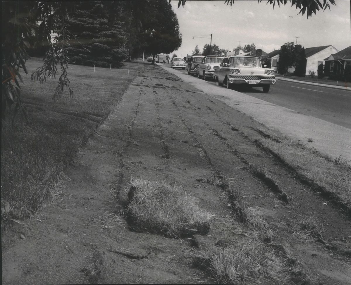
Still, it wasn’t enough. In 1951, the city approved work to pave and widen Wellesley between Division and Market streets, a $98,867 project. The project had been “on the griddle” for a decade, said City Engineer Charles Davis, and would double the width of the road, from 30 to 40 feet. The 30-block project removed 168 street trees.
Again, it wasn’t enough. A decade later in 1962, city officials said Wellesley had to be even wider. Forty feet wasn’t enough to accomodate the four-lane arterial street they envisioned, which had been approved by voters that year as part of a $2.9 million arterial street bond.
Residents along the road protested, saying they were “fearful of losing landscaped front and side lawns” to the 58-block, $741,000 project. In November 1962, the Spokesman described the fears as premature and clueless.
“Much of this is city-owned property, as it is across the city, has been landscaped with grass, shrubbery or flowers,” the article read. “In other words, homeowners have come to consider the city property as their own. Many appear not to be aware that a strip of property bordering the curb actually belongs to the city.”
Unaware or otherwise, a coalition of 300 residents took their case to the City Council in December 1962. A “spillover” crowd at City Hall protested the widening because “it would cut away too much land in front of their homes.” Instead of the widening, the coalition said they were in favor of making Wellesley a one-way street.
City Engineer Elmer Leland said the idea was unworkable, noting that the nearest street to carry one-way traffic the opposite direction was Queen Avenue – a quarter-mile north and too far away.
At the time Wellesley carried 10,000 cars a day, and traffic was growing on it faster than any other city street. That led Vaughn Call, a member of the city’s plan commission, to issue dire warnings.
“If we don’t have arterials, Spokane will cease to function as a city,” he said.
Wellesley residents had the opposite view.
At the December council meeting, John Haworth testified that he had lived on Wellesley since 1922 “when the weeds were still growing in the street.” He warned council members that “you will be creating a hazardous situation if you make Wellesley an arterial. … We have trouble getting out of our driveways as it is. It will be impossible if you go through with your plan.”
The rowdy crowd agreed, eventually pushing Councilman Jerry Kopet “to rap his gavel a number of times when the project’s detractors voiced their protests too loudly.”
Responding to these protests, Mayor Neal Fosseen held a public meeting later that month to discuss the widening, as well as the possibility of establishing a one-way couplet on Wellesley and Queen. By this time, the residents’ concerns had grown. Aside from losing lawn, they said their opposition “stemmed principally from the increased traffic it would bring on Wellesley, the increased volume of fumes from trucks and cars and the ‘bringing of fumes right up to our houses,’ the cost of the project to the taxpayers and the increased danger to the school children who cross Wellesley,” the Chronicle reported, quoting homeowner Frances Brisinda.
Despite opposition to the “explosive problem,” the Spokesman reported in mid-December that there was a “definite swing among City Council members back to the originally proposed 58-block widening.”
On Jan. 7, 1963, before a capacity crowd at City Hall, the council voted 5-2 to widen Wellesley. Kopet, who voted for the widening, called the vote “a hard one for me. I have lived in that neighborhood. Many people affected are good friends of mine. I’d like to duck voting on this, but I believe widening of Wellesley is essential to the city.”
The residents were not mollified. Among them was McDonald and her “1,000 mimeographed petition forms, with space for 33 signatures on each.” Though the Texan Nabers was her prime target, her petitions also asked for the firing of other “imported” city officials and their replacement with “Spokane men.” She gave a form to Nabers and other city officials “so that they would know that we aren’t doing this behind their backs.”
McDonald’s activism didn’t stop the road widening, and work began that summer. It would’ve been completed that year if it weren’t for a reported 100 property owners who refused to yield to the city’s plans.
As the city struggled to acquire these lots, five city staffers were put on the case to get the property needed for the project. City Engineer A.M. Eschbach said the property would be got one way or another, either through a settlement or the courts. The work would begin. “This means there would be some unacquired properties jutting out beyond the widened parts of Wellesley,” the Chronicle reported in July 1963.
In August 1963, Eschbach sent a letter to owners of 56 parcels saying the city was “extremely desirous” to acquire their land. The letter also served as a warning, noting that “if we are forced to condemn property” the city must file action with the courts “so we can get on the busy court calendar by this fall.”
In October 1963, the city did just as Eschbach warned and filed condemnation actions with the courts. The Chronicle printed the names of every property owner the city was working against. Among them were Trinity Evangelical Lutheran Church, North Hill Christian Church, Washington Water Power Co., Old National Bank and many individual homeowners.
Over the coming months, the Spokesman and Chronicle reported the steady drip of settlements and jury verdicts. By the end of January 1964, all but two parcels had been acquired. Most of the property had been gotten through direct negotiations, said the new city manager, Frank Sylvin Fulwiler, who had replaced Nabers after his short two-year tenure as the city’s first manager ended due to clashes with the council.
That spring, the Wellesley work was completed and the council passed a no-parking ordinance on 52 blocks of Wellesley between Market and A so it could “be utilized as a four-lane arterial.” Peak traffic brought 1,200 cars per hour to the street, and daily traffic reached 12,400. Leland, the city engineer, estimated that traffic would double in 20 years.
At the end, the widening of Wellesley cost $1,003,176. About $293,000 was used to purchase property. The federal government paid for half of the project, and more than 20,000 tons of asphalt were laid down for pavement.
With the “turbulent past dimming,” the city had an official unveiling of Wellesley, where city officials and people from the Chamber of Commerce and Good Roads Association piled into a bus at 11:10 a.m. at City Hall and toured the project. A reporter for the Spokesman joined them.
“Wellesley, formerly a narrow arterial, is now a slick stretch of black asphalt stretching 56 blocks from Market to A. It offers a floating-on-air type of ride,” the reporter wrote in October 1964.
Nowadays, more than 50 years after neighbors fought the widening of Wellesley, the road remains a four-lane arterial. Despite Leland’s predictions, traffic hasn’t doubled. Between Division and Market, the road sees an average of between 11,500 and 15,000 vehicles a day.
And there’s still no parking allowed.