This column reflects the opinion of the writer. Learn about the differences between a news story and an opinion column.
Getting There: Plans for Centennial Trail through West Central draw pushback that could result in new connection
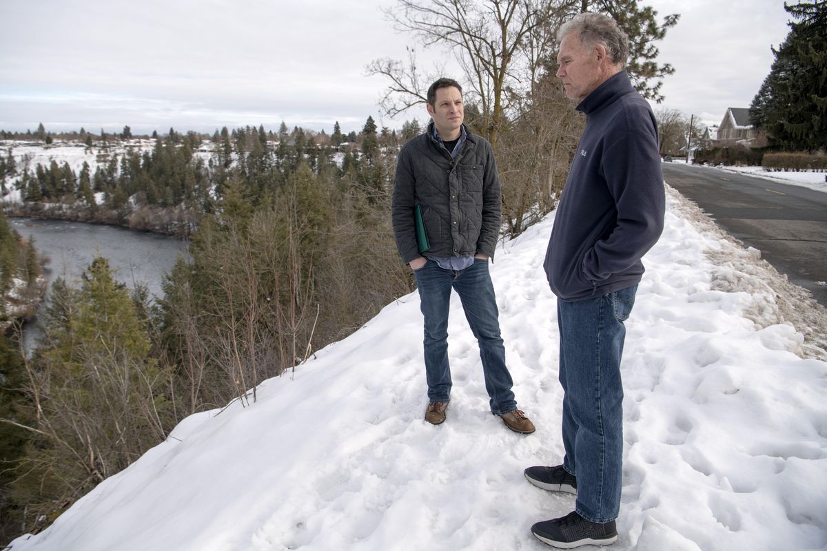

The only signs that the Centennial Trail runs along the northern edge of West Central – via West Summit Boulevard, West Mission Avenue and North West Point Road – are, well, the signs.
They’re small signs, adorned with the trail’s pine-tree logo, that show the way to users who may not know where to go once they come to the end of the Centennial Trail’s dedicated shared-use paths at Summit and Boone avenues or at the top of Doomsday Hill, on Pettet Drive.
But that is about to change, if a long-awaited plan from the city of Spokane moves forward as expected this summer.
That plan would use a $2.53 million federal grant to replace a series of sidewalks, some of which are deteriorating under the melting snow, with a raised path between about 10 and 12 feet wide and buffered from the street.
“All we want to do is just improve what’s here, make it nicer for all users,” Loreen McFaul said while walking the route on a recent rainy afternoon.
McFaul is the executive director of Friends of the Centennial Trail, a nonprofit that advocates for the maintenance and completion of the nearly 40-mile-long paved path that stretches from the Nine Mile Falls Recreation Area in Riverside State Park to the state line, where it joins the North Idaho Centennial Trail and continues for another 24 miles.
The trail has nominally been around since 1989, when a route was imagined and drawn up on existing paths and streets. But advocates, corporate sponsors, donors and various governments have spent the past 31 years working to make a dedicated, separated and official Class 1 trail a reality.
Class 1 is a designation for a shared-use path that is separated from the street, with enough width to accommodate bikes, pedestrians and other nonmotorized users. Most of the Centennial Trail now meets those requirements, with a half-dozen short exceptions.
One of those is the gap in West Central. It’s a crucial missing link in the Centennial Trail. On one end, to the west, is Kendall Yards, downtown Spokane and the University District. On the other end is the top of Doomsday Hill, which drops down to the T.J. Meenach Bridge, crosses the Spokane River and connects to the trails that pass through Riverside State Park.
Once the path along the north side of Summit, Mission and West Point is complete, McFaul said, those pieces will be brought together.
While Friends of the Centennial Trail didn’t spend money on the project and isn’t involved in its design or construction, McFaul said she’s “excited” about it, as is the city of Spokane, which earned the grant that will pay for the work and is currently working to design the path’s course through the northern edge of West Central.
But not everyone is on board.
A group of residents, some of whom live across the street from the planned Summit Boulevard stretch, have organized an effort to push back against the city’s plan, circulating a petition signed by about 60 people and starting a website, notsummit.org.
“Like you, we enjoy our beautiful and peaceful, Summit Blvd, Mission Ave, and West Point Rd. for running, cycling, and just strolling to see the view,” the website states. “We hate the ancient, broken sidewalk and the bumpy road, but we’re coping with it.”
The city’s plans, the website says, came as “a huge shock. It mobilized us to learn more and see if this City proposal is the best for everyone.” They have found, the website states, that it isn’t.
Among this group of mobilized residents are Mike and Sue Etter, who have lived on the street for 42 years, and Larry Swartz, who has been there for about 15 years. All told, Mike Etter estimates eight to 10 people are actively involved in the effort.
“None of us are against the Centennial Trail,” he said on a recent morning.
But they are against the city’s plan to close the gap in West Central with a dedicated trail along Summit, Mission and West Point. The Etters and Swartz say their concerns are many and involve everything from safety to property rights to aesthetics.
Jonathan Adams, a senior engineer with the city of Spokane and the Summit gap project manager, said the plan as it stands now would involve some disruptions, including building the path through about five front yards that extend into the city’s right-of-way, crossing some driveways and turning West Point into a one-way street going south. But he also said he’s working with affected residents to deal with their concerns.
“I’ve talked to quite a few of them so far, on an individual basis or group emails or whatever they want,” he said.
The Etters and Swartz argue, however, that the city’s plan came as a surprise to them and that it hasn’t been sufficiently thought through.
“What’s it going to do to the safety issue?” Mike Etter said. “What’s it going to do to the street?”
They say they like how their neighborhood is now, with cyclists, pedestrians, buses and cars passing along Summit without a shared-use path that would likely lead to narrowing the roadway, might lead to the addition of some railings along the bluff and would put different kinds of users on a single, shared path to an unappealing end.
“You’re not filling the gap,” Swartz said. “It sends you to a place nobody wants to go to.”
Namely, he said, to the top of Doomsday Hill.
Their goal, according to Swartz, is for the city to realize its error, abandon its plan in West Central, send the grant money back and “hopefully leverage it toward a project that makes more sense.”
That alternative plan would send the Centennial Trail below the Summit bluff, over the Spokane River, and across to what is now a series of trails along the river and below Spokane Falls Community College. There, it would meet up with the Centennial Trail again beneath the T.J. Meenach Bridge.
They argue that plan would make for a more isolated, idyllic and safe connection from where the developed trail currently ends on Boone. And they say this alternative is one the city has been considering for years, and the one they thought the city preferred.
It’s true that the city has, indeed, long had in its sights a span across the river and a connection to the trails on land it acquired in 2017.
“It’s certainly something that we’ve talked about,” said Marlene Feist, a city spokeswoman. “It would be a beautiful trail. I don’t think anybody disagrees with that.”
But it’s also true, Feist said, that the city has spent more than a decade trying to complete the Centennial Trail’s Summit gap. That process began decades ago, with the route’s official designation and the installation of signs along the street. And the process continued with the inclusion of plans in various City Council-approved bicycle and streets plans going back to 2009.
According to Feist, the City Council has had seven “touches” on the plan, including approving at public meetings its inclusion in street plans for four years in a row. Feist said the council’s public works committee was also briefed when the city sought both planning money and the $2.53 million grant from the federal Congestion Mitigation and Air Quality Improvement program.
So while she acknowledged that it’s a “challenge for us (the city) in general” to ensure people are aware of its many projects and plans, Feist pushed back on the idea that the planned work on the Summit gap came up suddenly or without public involvement.
“These things are hard to get people’s attention in their daily lives until they become much more concrete,” Feist said. “And that’s partly why they elect leaders.”
She also said the city hasn’t forgotten about the more complicated and costly possibility of building a bridge over the river to provide access to the newly acquired land on the far side.
The formal process of getting it on a six-year city plan is “just starting,” with city officials now “looking at how to get it on that path to get to get it done.”
As for the idea that spending money on the Summit gap will undermine the possibility of pursuing a bridge connection, Feist said that “one doesn’t compete with the other.”
“In fact, the congestion mitigation money that we received for this (Summit gap) project wouldn’t be applicable in a rustic setting like that,” Feist said. “It’s not a statement of whether that’s a good project or not. It’s just that this particular dollar wouldn’t be able to be spent that way.”
She said that spending the money now to connect a Class 1 Centennial Trail from Boone to Pettet , has lots of benefits that will extend far beyond West Central.
“It really does serve more than just the immediately adjacent neighborhood and streets,” Feist said. “It’s about how you can move in these alternative modes of transportation … and get into our core to commute from northwest Spokane.”
Mike Etter said he wasn’t aware that the trail officially runs past his house now, and that the city’s plan to pursue both projects doesn’t change his mind.
“Why can’t you take a step back?” he said. “Let’s revisit this thing. Let’s not just say, ‘Because we’ve got the $2 million, let’s do it.’”
Not everyone in the neighborhood opposes the project, though. Keith Kelley, a landlord and West Central Community Center board member, said he’s “all for” the plan.
“It would seem to be a value added to the neighborhood and to the community-at-large to extend this widely used trail for outdoor recreation purposes,” Kelley said. “The river is an exquisite part of Spokane’s landscape and deserves to be enjoyed.”
McFaul, of Friends of the Centennial Trail, hopes the engagement from residents along Summit can be harnessed to make real the long-imagined plan for a new bridge and new access.
“I think maybe this project has activated others who may be interested in pursuing a high-span bridge across the river to the other trails across the river,” McFaul said. “If one trail spurs another, that’s great.”
In the meantime, the Centennial Trail project will be the subject of discussion today at 1:15 p.m., during a meeting of the Public Infrastructure, Environment, and Sustainability Committee in the Council Briefing Center, Lower Level, City Hall, 808 W. Spokane Falls Blvd.
And that’s not all on the Centennial Trail
The Summit gap project is just one of a number of projects slated for the Centennial Trail this year.
Perhaps most notably, plans are in place to replace the decking and railing on the Don Kardong Bridge, which crosses the Spokane River near Gonzaga University. The $1.3 million project from the city’s Parks and Recreation Department should be underway this spring or summer and completed in the fall.
Work is also planned to begin in the spring on the Post Street Bridge. Those plans would place the Centennial Trail on the west side of a brand-new bridge. Replacement of the bridge is expected to take about 20 months, according to the city website.
Other upcoming trail projects include a plan to move about a half-mile of trail farther from the road, starting at the Carlson Trailhead toward Nine Mile Bridge, and to add three new counters to the existing four that keep tabs on how many people use the trail. According to McFaul, existing data suggests some 2.5 million people utliize the lengthy path each year.
Work to watch for
Few road projects are still going this time of year, but keep your eyes peeled for crews in a few stretches this week.
Wall Street will be closed between Second and Third avenues on Tuesday for Avista work.
The inside southbound lane of Browne Street between Fifth and Sixth avenues will be closed through Wednesday for CenturyLink work.