Thousands still have no power in the Spokane area as near-record lows approach
Thousands in the Spokane area were still without power Saturday as near-record low temperatures crept in following a historic October snowstorm that snapped branches onto power lines.
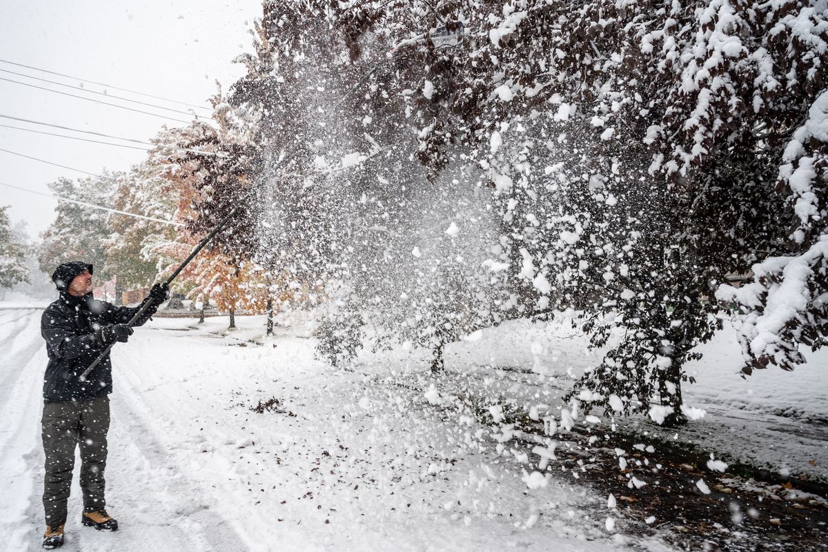
A whopping 6.9 inches of snow fell Friday, shattering the previous record of 5.9 inches in 1957. But the storm had an even bigger impact when the early hours of Saturday are factored in, with a grand total of 7.5 inches falling at the Spokane International Airport, the National Weather Service said.
That burden on trees still weighed down by their leaves led to car crashes and widespread electrical outages, leaving thousands of Avista Utilities customers alone to face a night in the low teens without power.
“We’re talking 20 to 25 degrees lower than normal,” Spokane National Weather Service forecaster Laurie Nisbet said.
Here’s a look at the public safety impacts from the unprecedented storm:
Power outages widespread as near-record lows predictedAt the peak of the storm, more than 20,000 Avista Utilities customers lost power.
As of 5 p.m. Saturday, 4,173 Avista customers – the utility’s term for residences, not people – were still without power. A utility spokesman said he didn’t know how many people lived in the affected homes.
Most of those customers were expected to have power back by Sunday night, the utility said in a press release, but that meant a night of potentially record-breaking cold without power for them.
“Avista understands how challenging it is to be out of power during these colder temperatures, and we thank our customers for their patience,” the utility’s statement reads.
When asked what residents without power should do to prepare for the cold, a utility spokesman referred people to Avista’s general outage page and said the company would “encourage customers to seek community resources as needed.”
Meanwhile, an additional 1,100 or so were without power in Kootenai County with small outages in Benewah, Clearwater, Latah, Shoshone and Stevens counties.
All told, Avista reported 502 separate outages.
Inland Power and Light, on the other hand, reported 46 customers without power Saturday night. Kootenai Electric had 20 outages affecting 467 customers Saturday morning, but the number had gone down by Saturday evening and power was expected to be back by 9:30 p.m.
Spokane Fire Chief Brian Schaeffer said it’s crucial residents keep safety in mind during an outage, though he noted many have generators and other backup sources of power.
“It’s not appropriate to use an open flame without ventilation inside your home,” he said. “Going to public facilities in lieu of staying home (in the cold), checking on your neighbors who may be out of power – that’s very important.”
Fortunately, Schaeffer said, the fire department didn’t get any reports during the storm of carbon monoxide poisoning, which can happen when people bring heaters inside that are meant for outdoor use, for example.
And even if you didn’t lose power, Schaeffer said residents need to be mindful of fallen electrical lines after a storm – especially since they’re not always easy to spot.
“The power lines are often camouflaged inside those (fallen) trees,” he said. “It’s extremely tragic to lose somebody to an electrocution when they’re trying to help. It just takes a few minutes to really look critically at those branches and just ensure when you go to move them that there are no lines in those trees.”
‘Managed chaos’ for fire and law enforcementThe rapidly accumulating snow also caused crashes and slowed or stopped traffic on local roads.
Schaeffer said his department got 222 calls from 8 a.m. Friday to the same time Saturday – a stark increase from the department’s daily average of 120.
“We’ve essentially doubled the number of responses within the last 24 hours compared to last year,” he said. “The system’s been overwhelmed.”
The department also responded to 25 injury crashes.
“The storm didn’t discriminate, in terms of locations,” Schaeffer said. “We had outages and fires reported from power lines down and exploding transformers all throughout the city.”
Four of the department’s fire stations were among the many buildings that lost power, Schaeffer said.
“For us, it was managed chaos,” he said.
Traffic on eastbound Interstate 90 just west of Spokane was slowed to a crawl for quite some time Friday afternoon, and state Highway 27 was closed for about an hour after a crash near Freeman. The Washington State Patrol reported responding to 91 crashes in Spokane County.
.
By Saturday, all that snow had led to some 200 calls reporting tree limbs in the roadway, said Marlene Feist, director of strategic development for the city’s Public Works and Utilities department.
What’s next? The weekend is expected to be sunny, which should help road conditions, the weather service’s Nisbet said.
Still, the area may break another weather record this weekend. The current record low for Oct. 25 is 12 degrees, set in 1919, and Saturday’s forecasted low was 13 degrees. Forecasters originally predicted a low of only 10.
Feist said the city has been prioritizing roads to plow based on traffic, and crews have also been sanding and using de-icers on some roads. The county has also been using plows and de-icing.
But the extremely cold temperatures are still likely lead to dangerous black ice in some places, particularly roads in the path of drainage.
“They will freeze back over, so that’s a concern,” Feist said. “So people just need to be careful.”
Compared to driving in snow, Feist said, “The black ice might actually be harder, in some cases, because you can’t see it.”
It’s also important to factor in where you are in the region when thinking of black ice.
In the city, it’s more likely to be hiding in the shadows of tall buildings, while in remote areas, it’s trees and hills that give the chilly shade, said Martha Lou Wheatley-Billeter, public works information and outreach manager for Spokane County.
“You really need to slow down; you need to give yourself plenty of time to get where you’re going,” Wheatley-Billeter said. “We go through this when the first snows fall every winter. We have a rash of car accidents because people don’t take into account the changing conditions.”
Besides slowing down, she recommended people have emergency supplies in their vehicles to prepare for slick roads or getting stuck.
Wind gusts of 20 to 25 mph are expected in the Spokane and Coeur d’Alene area Saturday. The wind chill will be in the low single digits or near zero in much of the area overnight, Nisbet said.
“The winds are going to pick up from the northeast,” Nisbet said.
And overnight temperatures will get even lower in places like Deer Park and Pullman.
The high temperature on Sunday is expected to be between 32 and 35 degrees. The low temperatures Monday morning are expected to drop to 13 at the airport. That’s well below the average low of 35 for that date, Nisbet said.
But the frigid overnight lows are expected to start improving on Tuesday.
“We start to warm up a little bit,” Nisbet said. “By Tuesday we warm up to 40 degrees.”
North Idaho and the northern valleys in Washington can also expect to see fog in the morning on Tuesday and Wednesday.
“We’ll definitely start seeing more widespread fog and low clouds Wednesday and Thursday of next week,” she said.