This is what mountaintop removal mining looks like
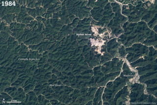
Check out this series of photographs from NASA's Landsat 5 satellite. These images were taken over 26 years from 1984 to 2010 and it shows the toll mountaintop removal mining takes. The so-called "restored" scars never look the same as the barren landscape expands, looking like it was bombed. According to the NASA Report, in February 2010, a team of scientists published a review of research on mountaintop mining and valley fills in the journal Science. The scientists concluded that the impacts on stream and groundwater quality, biodiversity, and forest productivity were "pervasive and irreversible" and that current strategies for mitigation and restoration were not compensating for the degradation.
This is the nasty picture.
Also check the New York Times article on Lindytown, which was bought out and turned into a ghost town by Massey Energy. Obviously, they don't want people living too near its mountaintop removal operations where reports came of the town being covered in dust and flying rocks from explosions:
The coal that helped to create Lindytown also destroyed it. Here was the church; here was its steeple; now it’s all gone, along with its people. Gone, too, are the surrounding mountaintops. To mine the soft rock that we burn to help power our light bulbs, our laptops, our way of life, heavy equipment has stripped away the trees, the soil, the rock — what coal companies call the “overburden.”