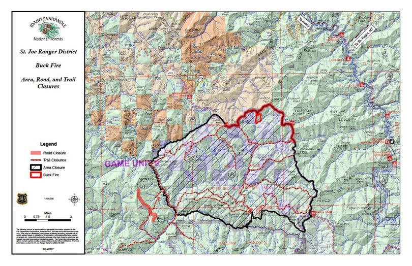
Buck Fire closure affects Mallard-Larkins, St. Joe-area trails
UPDATED WITH HIGHER RESOLUTION MAP.
TO DOWNLOAD OR VIEW THE HIGH RESOLUTION MAP, CLICK HERE
HIKING -- A wildfire in the St. Joe River District is restricting public access to some popular hiking destinations including Snow Peak and the Mallard-Larkins Pioneer area.
The Idaho Panhandle National Forests is temporarily closing portions of Forest Service Roads #201 and 363, Trails #13, 40, 50, 55, 99, 100, 101, 102, 104, 106, 106A, 107, 117, 141, 62, and the portion of Trails #50 and 108, according to a release posted today.
An area closure is in effect for the vicinity of Snow Peak (see map) in Shoshone County on the St. Joe Ranger District.
"These closures are in place for public health and safety due to fire activity from the Buck Fire, and are expected to continue until the fire situation allows safe access and passage," the release says.
Note: Surveyors Lookout and Northbound Creek Trail #111 remain open at this time.
Access to Surveyors Lookout and Sawtooth Saddle remain open via Beaver Creek (FSR #303) and the portion of FSR #201 south of the Beaver Creek junction.
The Buck Fire was detected on Aug. 8. It is approximately 105 acres and is 20% contained.
Info: St. Joe Ranger District, Avery Office (208) 245-6200, or St. Maries Office (208) 245-2531.
