Spokane cyclists won’t get lost anymore
Taking two wheels through Spokane is a daunting prospect. There are hills. There’s a river running through the middle of town. This time of year, there’s nasty weather. And those cars! But there’s an effort afoot at Spokane City Hall to make the cyclist's journey a bit easier – by remaking a map.
Inga Note is a city planner who is currently all in for rethinking how Spokane helps its bikers get around. Everything’s on the table, she said, but the best practices include having bikeways at least every half-mile; widening bike lanes to six feet instead of the five foot width the city currently employs; and building bike facilities for transportation, not recreation. Note also said she’d like to take engineers into the field on bikes, which sounds like a blast and I want to go.
Note’s tasked with redesigning the city’s bike map to clarify its way-finding legend, making the city’s current, inscrutable map into something that should actually help cyclists traverse the Lilac City.
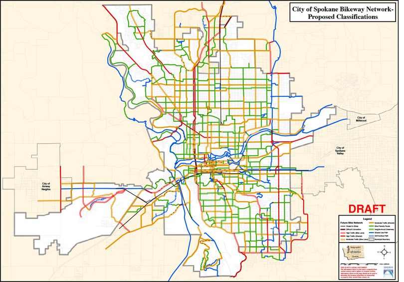
Right now, the map has five bikeway classifications: bicycle boulevard, bike lane, shared roadway, shared use or multiuse path, and marked/shared roadway. These words are fine if you know what they mean, but even then they don’t help riders who want to know a road’s speed limit or how much car traffic it handles. If you're new to bikes? Forget it. What's a bike boulevard?
Note’s new classifications should help most everyone who takes to a saddle. The new (draft) classifications take into account two main factors: the amount of traffic and the presence of a bike lane.
On the map attached at the bottom of this post, you will see four colors. Red means the road has a high level of traffic, yellow means moderate traffic, green means very low traffic and blue means there are no cars (think Fish Lake or Centennial trails). If the line is solid, the road has no bike lanes. If it’s not solid, there’s a bike lane.
Finally, the dashed red line means the road is a difficult connection.
Keep in mind the map is in draft form, which is why there are no street names and no legend. But what do you think? Is the map easier to read? Is the city moving in the right direction when it comes to bikes? What more should be done?
Click here to view a larger map: Bike map PDF