Canal head gate reminder of agricultural past

On the south side of Post Falls is Falls Park with its ponds, green lawns and paved walkways. There also is the 100-year-old head gate of a canal system that turned the once arid Spokane Valley into an agricultural paradise, once noted for its apple orchards so extensive that they inspired the naming of a road, “Apple Way.”
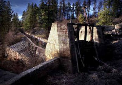
Today, this head gate which once controlled water to an extensive canal system that watered acreage between Post Falls and Spokane, may not look like much with its heavy, horizontal timbers bolted to upright supports and suspended between aging concrete abutments. Nevertheless, the gate along with the canal whose route runs roughly between the Spokane River and Interstate 90, is a recent listing on the National Register of Historic Places.
Both the canal and Daniel Chase Corbin, the man behind its construction, played significant and extensive rolls in the early development and prosperity of the Inland Empire of the Pacific Northwest.
Corbin was born in Newport, N.H., in 1860 and followed his fortune westward. After the discovery of the Sullivan and Bunker mines in the Silver Valley, he became involved in mining and built the first ore concentrator in the Silver Valley.
Corbin is likely best remembered for his involvement in the building of railroad lines. In 1886, seeing a need, he along with Sam T. Hauser, Austin Esler, S.S. Gliden and James Wardner, formed the Coeur d’Alene Railway and Navigation Co. for the purpose of building a narrow gauge railway to connect the end of navigation on the Coeur d’Alene River at Cataldo with the mines of the upper valley. Eventually that line was sold to Northern Pacific Railway Co.
In 1889 he also built a Northern Pacific branch line from Spokane to Loon Lake, Wash., and launched Loon Lake Park. His railroading interests extended north of the border to Canada.
In 1889 he also brought the first irrigation water to the Spokane Valley when his Spokane Valley Land and Water Co. signed an agreement with Washington Water Co. for water rights with the intention of bringing irrigation to 20,000 acres.
Today, a tumbled heap of sofa-sized boulders blocks water from the intake canal from reaching the head gate itself which, although aged and permanently closed, remains in its original condition. When operational, the gate was opened and closed to control the flow of water with cogged tracks installed in the gate and the concrete abutments.
Just downstream of the first gate is a second gate used to control the amount of water entering the canal system.
According to the nomination form for the National Register, Washington Water Power “…operated a head gate at the canal by at least 1904. By 1907, the company used the head gate to control and measure the flow of water into the irrigation system.”
The actual canal, which runs along a hillside above the Spokane River, begins at the second head gate. According to the nomination form, beyond that head gate, the canal has poured, concrete walls about 6½ feet high and about 15 feet across. “Farther downstream the walls slant outward and they gradually flare out to a lined canal that is 8 feet across on the bottom and 24 feet across on the top edge with sloping walls.”
The nomination form points out that this section of the canal ended at a ravine, where a wooden flume was probably built to carry the water across a gully. The author of the register form, Nancy Renk, also states that the canal was probably originally unlined but was lined with concrete between 1924 and 1926. Other historical sources seem to agree, citing the loss of water due to the porous nature of the gravelly soils and basalt, eventually creating a need for a liner.
The next part of the old canal, about three-quarters of a mile long, runs through an area of homes. Several years ago Kootenai County deeded this property to the adjacent homeowners and some of the canal remains intact, but other parts have been filled in. This section is not included in the National Register designation, nor is the Falls Park area because of alterations.
The final portion of the canal listed on the National Register is a mile long. begins at Breezy Way and ends at Spokane Road. This is mostly a rural area and is particularly important, according to the nomination form, because, “it retains integrity of location, design, materials, workmanship, association, setting and feeling.” The key word is “integrity,” a must in acceptance of any property to the National Register.
In total, only about 2½ miles of the canal remain, out of a system that once was 35 miles long, with numerous smaller canals that irrigated thousands of acres. According to historical observation, the native grasses, probably bunch grass, were green only in the spring. The rest of the year, the land was dry and dusty.
This canal earned its place on the National Register because of its importance in beginning the irrigation of the Valley of the Spokane River, providing a service that brought with it orchards and truck farms and the prosperity they created.
Eventually other irrigation districts were formed, pumping water from the aquifer, a more reliable source than the canal system which lost water in the glacial soils. Gradually, the original canal fell into disuse and disrepair.
The Depression of the early 1930s and the growth of orchards in the Yakima Valley spelled an end to the orchards of the Spokane Valley. Eventually, large-scale truck farming came to an end with the Valley turning to manufacturing and suburban housing developments.
Much that Corbin built is now gone or has been altered by time and new ownership, but some remains.
Like other men who struck it rich in Idaho mining and early railroading, Corbin built a mansion on Spokane’s South Hill, which still overlooks the city. Now known as the Corbin Art Center, the Georgian Revival home was designed by Kirtland K. Cutter.
However, the family never lived there. Mrs. Corbin disdained Spokane as too primitive and moved, with her two daughters and son, to England, where the eldest daughter, following the pattern of many well-to-do, American heiresses, married into the British aristocracy.
Austin, the son, eventually returned to Spokane to work with his father. The younger daughter also returned and became the first wife of the architect who had designed her father’s home.
While much has changed, two structures Corbin built remain, tangible links to a man who played a significant roll in the growth of our region: the remains of a canal and irrigation system that brought water to a parched land and an arts center in a home that is part of the Marycliff-Cliff Park District.