Trail offers fantastic view of Lake Pend Oreille

You meet the nicest folks when hiking in North Idaho.
During my recent hike of High Point Trail in Farragut Park, Dan Yeatts and Mary Ann McKnight, of Spokane Valley appeared from the brush with evidence of a fresh strawberry feast from a nearby meadow. Dan reported seeing an elk and a black bear the night before and recalled surprising a mountain lion in the rocks on a previous trip. Eagles are frequently seen in the high grounds and deer are common.
Besides fresh berries and wildlife, the Highpoint Trail offers an array of flowering plants, huge evergreens, a challenging trail and a great view of Lake Pend Oreille.
The first stop on this adventure should be a visit to the Farragut Ranger Station, located just off Highway 54 in Farragut State Park, to purchase a trail map and parking sticker. This trail suffers from less than ideal trail markings, so the map, along with a few tips from a friendly ranger, are essential to a happy trek.
The route comprising trails 43, 44, 48 and 47 offers a more gradual ascent to the viewpoint, while trails 42, 45, 67 and 68 provide a narrow path through boulders with an added view to the southwest and connection to the Scout Trail – a 7-mile extension to Bernard Peak.
Access: From Prairie Avenue and U.S. Highway 95, go north on U.S. 95 for 15.2 miles; turn right on Highway 54, then follow the signs to Farragut State Park. Stop at park headquarters for a trail map and more information and pay the parking fee. Turn right just past headquarters on South Road and drive a quarter mile to the trailhead on the right.
Length: Approximately 3 miles roundtrip.
Elevation: The summit at the parking lot is approximately 2,300 feet above sea level, rising to 2,800 feet at the viewpoint.
Use: Moderate.
Trail condition: Mostly well-packed trails with narrow and steep portions in the rock cliffs.
Difficulty: Easy to moderate on the main trails. Difficult in the rocks.
Restrictions: No motorized vehicles, $4 parking fee in park.
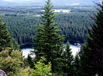
What to see: The reward for climbing to the top of this trail is the view of Buttonhook Bay on Lake Pend Oreille. This peaceful bay, first settled in 1866 and called “Pen d’ Oreille City,” was the second white settlement in North Idaho and provided a hub for miners. Steamboats took gold-seekers and freight from here to points along the lake for connection with horseback or stagecoach to mining camps. In its heyday, the city had a hotel, general store, billiard saloon and a half dozen log homes. The landscape includes giant boulders, reminders of the ice age when ice dams blocking the mouth of the Clark Fork melted and the resulting great floods created Lake Pend Oreille (depths to 1,150 feet).
Special features: Camping in Farragut State Park, boating and fishing in the lake. There is a Geocache (the treasure hunt game, using clues from the Web site, www.geocaching.com) near the viewpoint.
Preparation: Trail guide available at the Farragut State Park Headquarters and Visitor Center (208-683-2425). The ranger office suggests leaving your trip schedule with a responsible person. Detailed topographical maps are available for purchase from the following vendors in Coeur d’ Alene: Black Sheep Sporting Goods, The Yacht Club Sales and Service and North Idaho Blueprint.
Gear: Good hiking boots are essential, and hikers should dress for changing conditions, and carry drinking water and a first aid kit.
Note: Use care in the rocks; it’s a long way to the bottom!