Fire battle shifts to mountaintop
Blaze consumes 62 homes and 127,500 acres
LOS ANGELES – Higher humidity and slightly lower temperatures helped firefighters inch closer to subduing the monstrous fire that has lashed about the San Gabriel Mountains for a week, but they were scrambling late Tuesday in gusty winds to keep it from over-running Mount Wilson.
The reprieve from extremely dry weather had fire crews feverishly setting back fires and cutting fire lines throughout the day, bringing the fire’s containment from 5 percent in the morning to 22 percent in the evening. Southwest winds largely pushed the fire deeper into the wilderness.
Evacuation orders were lifted in much of La Canada-Flintridge and La Crescenta. But fire officials still worried about the northern flank of the fire, from Agua Dulce to Littlerock and said it’s possible the blaze could re-emerge as a threat to homes on the eastern flank.
“It’s still a very treacherous situation,” said U.S. Forest Service Incident Cmdr. Mike Dietrich. “The fire still has a lot of potential, and it’s still a big animal.”
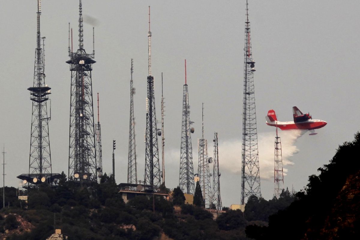
It remained particularly precarious atop Mount Wilson, home to the historic observatory and a complex of communications towers used by nearly 50 radio and television stations.
By mid-afternoon, the fire was making its closest incursion to the 5,710-foot peak yet, coming from two directions: one-half mile to the north and three-quarters of a mile to the west.
Controlled burns cloaked the mountaintop with acrid smoke. Chainsaws roared in all directions. Workers unloaded earthmovers from flatbed trucks.
So far the fire, whose cause is under investigation, has chewed through 127,500 acres of wilderness and destroyed 62 residences.
While the number of structures it has destroyed is small compared to other recent wildfires, this one has ripped an enormous hole in one of Southern California’s most treasured wilderness areas, a fact that was particularly evident along Angeles Crest Highway, which remained closed to the public traffic.
Under skies tinged coral and gray by dense smoke, mile after mile of slope once covered with manzanita, sumac, sycamore and pine trees looked like black dunes. Charred remains of squirrels and rodents lay by the road.
Joe Young, 63, who has hiked the San Gabriels for 39 years, said the burned area contains many of Southern California’s most popular hiking trails.
“It’s very sad,” said Young, a member of the Sierra Club’s 100-peaks group. “In just the burned area so far, we have about 40 peaks that club goes to regularly, if not every week.”