Rewards of rock-hopping off-trail in the Idaho Selkirks
Trails are effective infrastructure for guiding legions of hikers, bikers and horse riders into fragile high-mountain scenic areas while easing the effort, risk and impact.
But they’re not for everybody all the time.
Adventurous people head off-trail in search of hidden lakes, fishing holes, berry patches and exceptional viewpoints.
Cross-country routes can be shortcuts to destinations or direct routes to solitude.
They may be the most efficient way to get someplace, or not. In some cases, there’s only one way to find out: Go for it.
Climbers routinely scramble beyond trails to scale mountain peaks, knowing that off-trail hiking is riskier than staying on a maintained trail. Should an emergency occur, the victim will be harder to find away from a trail, less likely to get help and perhaps more difficult to rescue.
Getting lost is easier off a trail, especially if clouds move in and restrict views of landmarks or you descend the wrong devils-club-infested drainage.
Heading off-trail onto mountain ridges can present more exposure to falls, unstable boulders and fast-forming lightning storms.
The trick is to gauge cross-country treks to your abilities. Take maps, a compass and GPS technology.
And most of all, know when to bail out.
Hikers with map-reading skills can use a cross-country route to connect out-and-back trails into longer loops.
Some favorites cross-country links indicated as options in my guidebook “100 Hikes in the Inland Northwest” include the traverse between Silver Spray and Woodbury cabins in Kokanee Glacier Provincial Park to make a loop from the same trailhead.
The short Eagle Cap Wilderness triangle from Mirror Lake to Eagle Cap Peak traversing to Glacier Lake and back on a trail comes to mind.
In the Idaho Panhandle, hikers can link the Snow Lake trail with the Bottleneck Lake trail by scrambling up and over Bottleneck Peak on one of the sweetest little ridge walks in the Selkirks.
From that ridge, a scrambler’s eyes are drawn across the Pack River to Harrison Peak and Beehive Dome and a preview of a classic Selkirks one-day loop traverse.
The Harrison-Beehive Traverse links two popular trails to several spectacular mountain lakes in the shadow of 7,000-foot peaks.
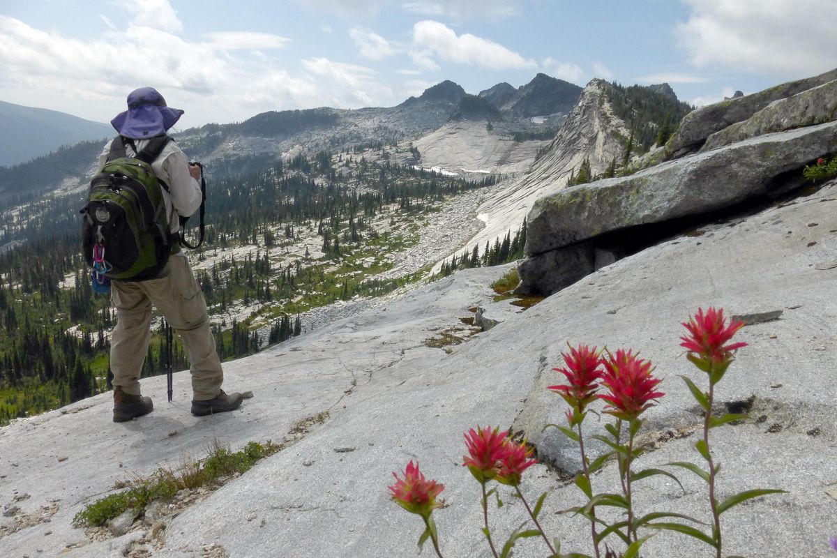
The traverse includes ridgeline walking on the Selkirk crest, cruising on sidewalk-like granite slabs, teetering on talus, scrambling over boulders and all the fruits and potential consequences of taking a gamble on your navigation skills and sureness of foot.
From U.S. 95 north of Sandpoint, head northwest on Pack River Road 231 for more than 20 miles.
As you drive up high on the slope beneath Roman Nose Peak and head toward the trailheads, Chimney Rock is briefly framed by the drainage to the west. Then pass the trailhead to Chimney Rock, a worthy 10-mile hike for another day.
A short way farther, eyes will be attracted to a massive bulge of granite known as Beehive Dome. It offers climbers almost 1,300 feet of continuous clean granite topping out around 6,200 feet elevation.
Next is the turnoff to Beehive Lakes trailhead with the Harrison Lake trailhead another mile or so up at the north end of the Pack River Road.
Some people include the road between the trailheads as part of the Harrison-Beehive Traverse loop. Most will leave a second car or stash a bicycle to make a shuttle. If you use a bike, consider leaving it at the Harrison trailhead for a mostly downhill ride back to your vehicle at Beehive trailhead.
If you’re starting at Harrison Lake trailhead, hike 2.3 miles to the lake, bear left, cross the outlet – the beginning of the Pack River –and trek through the granite slabs around the south shore.
At the northwest edge of Harrison Lake, hikers are on their own to find an unmarked route westward and steeply up the talus and scattered small trees toward a pass in the ridge. This ridge – on it, along it or below it –is your guide for about 2.5 miles southward toward Beehive Lakes.
One of the participants in a Spokane Mountaineers trip learned quickly that the traverse was not her cup of tea.
She breezed up the trail to Harrison, but she felt insecure when the route headed away from the lake and up through granite outcroppings and boulders. The group gave it some time, but eventually concluded they wouldn’t finish the traverse in a day at her super-cautious pace.
Like many before her, she wisely turned back and enjoyed her comfort zone along the lake and the maintained trails while the others proceeded up to the Selkirk crest.
Safe cross-country travel is all about judgment and minimizing risks. Avoiding bad weather days is an advantage as well as getting an early start to make sure you’re down to a trailhead before dark.
The cross-country portion of the Harrison-Beehive loop requires a lot of little navigation decisions.
Hike along the ridge at first, and along a few pinnacles. Then, unless you’re a skilled climber geared up with ropes, hikers should drop off into the granite basin above Little Harrison Lake and skirt below The Fin – a very narrow and precipitous portion of the ridge.
In the boulder field above Little Harrison Lake – a Selkirk Mountains gem – are a few easy-to-miss pieces of airplane wreckage. A plaque summarizes the story: “Miracle Mountain: Irwin family of four walked away from plane crash of C-70040. 4-20-86. Praise the Lord.”
The next stretch in the traverse involves scrambling up to the right notch in the east-west ridge between Little Harrison and Beehive lakes. This can be tricky. As in many traverses, it might require a move with a bit of exposure.
“I’m getting older and may not be able to do this route in the future,” said Chic Burge, a longtime Spokane Mountaineer, after a brief puckering encounter with fear. “You start losing your balance.”
As he ages, he said, trails start looking better and better.
From the ridge, the group bushwhacked down to Beehive Lake, a popular hiking destination.
The group found the access trail, which is faint and marked with cairns at first. But once on the maintained trail, their pace quickened. Strides were longer. Walking was a breeze. Talk touched on the need for a post-hike beer.
The 4.5 miles of switchbacks and decent grades to Pack River Road was enough to erase any reservations Burge might have conjured up during the traverse.
“I love the variety of this trip,” he said. “I might do it again this fall.”