Diamond in the rough: Mica Peak Conservation Area transitioning to public use
The Federal Aviation Administration’s white navigational radar dome has drawn attention to the summit of Mica Peak since it was built by the Air Force in the 1950s.
Now the mountain southwest of Liberty Lake isn’t just an attraction that catches your eye. It’s becoming a destination.
Acquired in 2013 for $1.7 million through Spokane County’s Conservation Futures Program, 911 acres of formerly private timberland on the north and west slopes of the peak are being discovered by hikers, mountain bikers and others who seek outdoor open spaces by muscle power.
The increase in visitors to the Mica Peak Conservation Area started in August when the access parking area was completed even though the area has no designated trail system, so far.
“People are using it and for the most part, using it well,” said Spokane County Parks planner Paul Knowles. “Even this winter we saw consistent use from snowshoers and skiers.”
Developing the public access large enough to accommodate horse trailers at the gated end of Belmont Road cost about $210,000. The site doubles as a safe turnaround for Freeman School District buses as well as for fire fighters and snow plows.
Spokane County is just beginning to sort out the recreational potential of the Mica Peak Conservation Area. The backbone of a master plan will be a trail system, Knowles said.
Currently, users are following logging roads – most of the area has been selectively logged – plus a few single-track trails pioneered in years past by motorcyclists, often without landowner permission.
“A trail plan will decide how many roads continue to be used and where new trails might be built,” Knowles said.
“Horse folks like wider trails for better visibility. We’ll want to maintain access routes for fire fighting and emergency response.”
Two dozen volunteers from mountain biking, hiking and horse-riding groups have met on two Saturdays this month and dispersed using a smartphone application to map existing roads and trails.
“The application lets them take pictures of key features along the routes as they hike and we can put them all together,” said trail project coordinator Mike Terrell of Alta Planning and Design.
“They’re not just GPSing the existing routes; they’re giving us qualitative information on what they like and don’t like. They might like a waterfall but not a boggy area.
“Once we get the raw data, the challenge will be making sense of where the trails will go to avoid places that are too thick or steep, for example.”
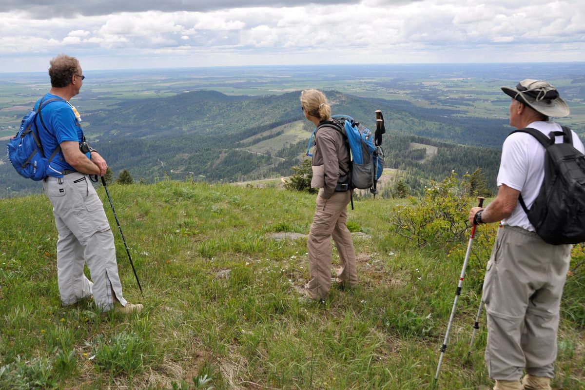
Visitors don’t go far into the conservation area before they have to head uphill. The area slopes up from elevation 2,800 feet to 4,800 feet. Exploring requires effort.
On the other hand, the elevation profile adds to the value of the experience. “Mica Peak has a range of views, flora, fauna and life zones,” Knowles said. “The diversity amazes me.”
The trail project’s goal is a multi-use, non-motorized trail system, but the reality is that high-speed mountain bikes and horses aren’t compatible on some terrain and trail widths.
“The design will try to balance the needs of all users,” Terrell said, noting that a master plan should be drafted by December and available for public review.
The area offers plenty of elbow room. “Dozens of people can be on the existing routes and hardly ever see each other,” he said.
A signed, designated trail system should address many of the concerns expressed by adjacent landowners and area residents, Knowles said.
“Mostly they’re concerned about managing increased use, spillover onto their lands and the potential for fire,” he said.
Mica Peak Conservation Area shares borders with Inland Empire Paper Company and the Washington Department of Natural Resources – two major landowners that allow public access, increasing the area’s value as open space and wildlife habitat.
But the ownerships require user groups to know the differing rules.
Hunting is not allowed on Spokane County conservation lands, but it is allowed on adjacent land managed by the Department of Natural Resources and by permit on Inland Empire Paper land.
“Hunting season was not a major issue last fall,” Knowles said. However, County Parks officials received calls from the public wondering why hunters were in the DNR land next to the conservation area.
“We’ve since installed signs to inform visitors that hunting and shooting isn’t allowed within the conservation area, but may be occurring on DNR or adjacent lands. That should eliminate some of that confusion come this fall.”
The 640-acre section of state land reached from the Mica Peak Conservation area’s Belmont Road access is open to hunting, but closed to use of motorized vehicles, said Brett Walker, DNR regional lands and recreation manager.
The agency is content with joining the other Mica Peak land holders in prohibiting fires and motor vehicles, he said.
“Shooting is an issue on some DNR lands and this is one of those areas close to a population that could be loved to death if people could drive in,” he said.
Inland Empire Paper Co. has prohibited public motorized vehicle access to its Mica Peak road system since 2011. The company has about 5,000 acres on the mountain divided into the 3,000-acre Starr Road and 2,000-acre Campbell Road blocks.
“The Star Road Block is a designated nonmotorized recreation area that’s in concert with other landowners,” said Paul Buckland, IEP lands manager.
The company requires visitors to purchase a permit to access most of its land for activities such as hiking, firewood cutting and hunting. “But the Starr Road Block is an exception,” Buckland said.
“The public does not need a permit in our walk-in-only nonmotorized area per our contract with the Washington Department of Fish and Wildlife.
“On the Campbell Road Block, it’s confusing. There is no legal access to the public even with one of our permits. To do so would require crossing someone else’s private property, so we cannot allow public access.”
Motorcyclists have been known trespass on private lands in the area and ignore the motorized use restrictions on county, state and paper company lands.
“Spokane County Parks land along with other property owners in the area are still having issues with motorcycles and we’re working to add more signage on the property and provide additional park ranger patrols,” Knowles said.
“Our neighbors have been helpful in reporting issues and contribute to the success of the new trailhead and conservation area.”
County Parks Ranger Bryant Robinson said he’s trying to increase his presence and make more educational contacts with dirt bikers.
“Eliminating motorized vehicles and dirt bikes up there is an ongoing challenge,” Knowles said.
Invading cyclists sneak into the area away from the Belmont access where the signs clearly say motor vehicles are prohibited. Many of the riders appear to be accessing the area from adjacent private lands, including residences along Belmont Road.
“As trails are improved, signage is installed, and more people visit the area – by legal means – those folks illegally using the park will slowly filter out,” Knowles said. “That’s one of many reasons why we’re developing a trail plan for Mica Peak.”
Mica Peak Conservation Area has plenty to explore at a slower pace.
“It’s a wild place with a lot of wildlife, including moose, black bear, deer, elk, cougar, wild turkey, bats, bunnies, hummingbirds and more,” Knowles said.
“A neat attribute is that you can get up high, into patches of birch and aspen and get great views. One open viewpoint about 3. 5 miles up from the parking area is a windswept ridge with Douglas firs and ponderosa pines. You can get views of the Spokane Valley and the Palouse.”
The county land does not extend all the way the summit of Mica Peak, elevation 5,205 feet, where radar facilities are operated by the FAA.
But there’s an equally good view from just west of the peak summit.
“The really special thing about the Mica Peak area is that it opens our eyes to the natural resources we have very close to a population center,” Terrell said.