Here’s a list of major fires contributing to Spokane’s smoky air
Update Thursday, Sept. 7:
Central Washington
Jolly Mountain fire
Ellensburg and Kittitas School Districts will close school until at least Monday, Sept. 11 due to increasingly poor air quality, the Yakima Herald reported.
The additional help from the Washington National Guard Wednesday helped spur fire containment to about 5 percent. It grew about 1,000 acres Wednesday into Thursday. It’s now at 26,325 acres, or 41 square miles.
Norse Peak fire
The fire grew modestly by about 3,000 acres Wednesday to 43,482.
About 11 miles north of Cliffdell off Chinook Pass and spanning two counties, the fire continues to threaten multiple structures on the western, Pierce County side of the blaze and has forced evacuations on the Yakima County side.
Crews were able to run a sprinkler system at Gold Hill, the Yakima Herlad reported, and laid similar groundwork for setups throughout Pierce County.
Diamond Creek fire
Still large, but slowing, this 164-square mile blazed remained hung up in rocky terrain just over Butte Pass at the head of Monument Creek, despite heavy smoke from a continued inversion, firefighters wrote on InciWeb, the national wildfire information service. Southeast winds spurred the majority of growth to the northwest in Canada.
Firefighters expect some growth along most areas of the fire due to near record-high temperatures and low humidity. Ground crews will continue to work on defensive lines around communities, especially in the Mazama area.
Bridge Creek fire
Crews continue to mop up the last of hot spots and work to fully contain the blaze.
Eastern Washington/Northern Idaho
North Fork Hughes fire
The fire has crossed the Bench Creek drainage and continues backing to the south near Hughes Meadows, firefighters wrote on InciWeb. They continue to patrol and monitor the Sullivan Creek Road as the fire backs down on the northwest flank.
It is currently at 3,520 acres, burning in steep, rugged terrain.
Western Montana
A series of fires continue to grow near Missoula. Weather experts say the wildfire smoke hovering over a large portion of the pacific northwest is due to an inversion system keeping smoke in the area. And a majority of the smoke in the area is from wildfires in Montana, which cover more than 750,000 acres, or 1,171 square miles, in size.
The Sprague fire
Firefighters reported little movement on the fire Wednesday night, though air quality remains poor and is limiting aircraft’s ability to fight the blaze. The advantage of the smoke, however, is a “dampening” effect it has on fire behavior by stabilizing wind conditions.
It’s at 13,343 acres and is 35-percent contained.
Rice Ridge fire
Little is new with this fire since Wednesday, other than a few thousand acres of growth. Fire managers are holding a community meeting Thursday night in the Seeley Lake Mission Bible Fellowship Church at 6 p.m.
The fire is at 120,759 acres and 5-percent contained.
Liberty fire
Fire containment is still at 17 percent. Fire is at 23,000 acres.
Highway 200 Complex
About 500 residents are threatened by this series of four fires. Evacuations remain in place near Sheep Gap Fire from the end of River Road to Arnold Road, at the corner of Section 11, firefighters wrote on InciWeb.
As with the Sprague fire, firefighters say lingering smoke has helped dampen activity on these fires as well. The Highway Complex, burning in the Lolo National Forest, is composed of the Sheep Gap, Deep Creek, Cub Creek and Reader fires.
Sheep Gap is 10,650 acres, 15-percent contained. Deep Creek is 4,455 acres. Cub Creek is 2,941 acres. Reader fire is 152 acres, 30-percent contained.
Caribou fire
Fire lines were improved to the west and north Wednesday. The fire saw minimal growth of about 800 acres, bringing it in to 17,897 acres.
Sapphire Complex
Composed of the Goat Creek, Sliderock, and Little Hogback fires, this blaze has overtaken 43,516 acres of Lolo National Forest. At 53-percent containment, firefighters wrote in InciWeb that the plan moving forward is to monitor the fire and reinforce fire lines where needed.
Lolo Peak fire
The fire saw little growth Wednesday overnight. Crews copmleted a 120-acre burnout operation south of Sweeney Creek recently in hopes of containing the 48,686-acre blaze.
About 530 homes are still threatened by the blaze.
Western Oregon
Eagle Creek fire
Information compiled by the Oregonian newspaper:
- 33,382: acres
- 1,865: residents evacuated
- 400: animals, mostly livestock, evacuated since it began
- 928: firefighters working the fire
- 20: miles of Columbia River restricted
- 40: miles of Interstate 84 closed
- 2: visits by Gov. Kate Brown since fire began
- 31: years the area has been designated a national scenic area
- 75: waterfalls in the gorge
- 4 million: visitors to Multnomah Falls each year
- 295,000 acres: size of Columbia River Scenic Area
The blaze continues to grow, prompting action from Oregon state legislatures to pay for fire suppression. The fire has made local and national headlines as it continues to burn unchecked in the Columbia River Gorge.
The 15-year-old, who is believed to have started the fire by misusing fireworks, will not be named, Oregon State Police officials told Oregon media.
…
Update Wednesday, Sept. 6:
Central Washington
Jolly Mountain fire
Responsibility of the Jolly Mountain fire was handed over to a national incident command team on Tuesday, which can provide more firefighters and equipment if needed, the Yakima Herald reported.
The fire grew about 6-square miles Tuesday into Wednesday. Over 770 firefighters are on hand.
Firefighters said on InciWeb, the national wildfire information service, that the plan of action is to monitor fire lines around property at risk along Cle Elum River Corridor, Dingbat, Teanaway Butte, West Fork, Middle Fork/Wagon Wheel, Lower North Fork and Upper North Middle Fork of the Teanaway River Community Forest structures and Cle Elum Lake communities.
Brent Hals, the mayor of Roslyn which is just south of the fire, told the Yakima Herald that concern is growing among the town’s 900 residents.
“This is a very serious fire, we have serious risk for people,” he told the newspaper. “All the assets we can use are here, and there’s a mini city of 700 people who have come from all over the country to help us fight this fire.”
Norse Peak fire
The fire, burning in the Norse Peak Wilderness Area of the Snoqualmie National Forest in Pierce and Yakima Counties, has doubled in size since Sunday, prompting level 3 evacuations for Goose Prairie along Bumping River Road.
Fire personnel engaged the western edge of the Norse Peak Fire southwest of the Greenwater Trailhead, and Greenwater Fire Department firefighters completed plumbing and installing sprinklers in the Gold Hill Community, firefighters wrote on InciWeb.
The western edge of the fire continues to threaten structures in Pierce County. Level 3 evacuations have been ordered for the Silver Springs Campground, Silver Creek, Deep Creek, Joke Creek, Alta Community, Pick Handle Basin, Goat Creek, Gold Hill Community and the Crystal Mountain Ski Resort area.
Diamond Creek fire
The largest of Washington’s wildfires by far, this 164-squre mile blaze continues to burn unchecked in the Pasayten Wilderness in northern Okanogan County near the Canadian border. It grew by about 16 square miles since Tuesday.
Because of the areas harsh terrain, firefighters haven’t been able to accomplish much in terms of fire suppression. About 65-percent of the blaze is contained, firefighters said on InciWeb, but the fire won’t stop burning until its put out by natural precipitation.
Bridge Creek fire
Crews continue to mop up the last of hot spots and work to fully contain the blaze.

Special Coverage: Inland Northwest Air Quality
Get the latest updates on air quality conditions from around the region here. | Read more »
Eastern Washington/Northern Idaho
North Fork Hughes fire
The fire remains active, having grown about 600 acres since Tuesday. Eleven firefighters remain on hand to monitor the blaze, which is burning in a remote, rugged area just north of the Hughes Meadows near the Washington state line.
Firefighters said on InciWeb that access to the fire is limited, which has hampered suppression efforts.
Western Montana
A series of fires continue to grow near Missoula, including several that have displaced hundreds of people and overtaken several structures.
The Sprague fire
The 13,000-acre fire burning in Glacier National Park saw little growth Tuesday and Wednesday, as firefighters say heavy localized smoke is causing a reduction in fire behavior.
“Managers, residents, and Park visitors are experiencing the pros and cons of smoke,” firefighters wrote on InciWeb. “Air quality is expected to be poor over the next few days because of the high pressure building almost directly over the fire. This results in stable conditions and light winds. The advantage of smoke is the ‘dampening’ effect it has on fire behavior.”
Firefighters also announced a soon-to-be installed “rain for rent” system in the Lake McDonald Lodge complex area – over 1,000 feet of mainline and 8,000 feet of lateral hand line with sprinklers designed to wet large areas to create a fire break.
Rice Ridge fire
One of the largest fires burning in North America, the Rice Ridge fire northeast of Missoula saw significant growth since Tuesday. At 185 square miles, 686 firefighters are on hand working to enforce fire lines and monitor growth. It’s located in a mostly remote area northeast of Seeley Lake.
Seeley Lake was reopened Wednesday, but firefighters warned planes may still swoop down to scoop up water. Evacuation orders were still in place for several thousand homeowners living along the lake.
Liberty fire
Fire containment rose to 17-percent Wednesday as the fire grew about 2,000 acres. A warming and drying rend is expected to continue through Thursday, meaning firefighters will monitor fire activity and complete indirect containment lines.
Caribou fire
On Tuesday, the 17,000-acre blaze claimed 10 homes and 30 outbuildings, the Lincoln County Sheriff’s Office said. Overnight, firefighters patrolled the fire line and searched for spot fires.
Today, firefighters said structure protection crews will improve fire lines southeast and north of West Kootenai, and extend the southern contingency fire line south of the community. Additional ground and air resources have been assigned, firefighters wrote on InciWeb, but aircraft cannot resume operations until smoke clears and visibility improves.
Lolo Peak fire
Crews were successful in completing a 120-acre burnout operation south of Sweeney Creek in hopes of containing parts of the 48,000 acre fire.
New closure orders were in effect for parts of the Lolo National Forest and the Nez Perce-Clearwater National Forest, firefighters said. They urged people to visit national forest websites for specific locations.
KPAX-8 News in Missoula reported 530 homes remain threatened by the blaze.
Western Oregon
Eagle Creek fire
Ash continued to fall on western Oregon as a dozens of fires burn east of Portland. The Eagle Creek fire merged with the Indian Creek fire, together burning 30,929 acres in the Columbia River Gorge.
The Columbian newspaper in Vancouver, Washington reported 600 firefighters are working to put lines around the fire and continue to protect the infrastructure in the area.
The Multnomah Falls Lodge, built in 1925, was saved by firefighters.
Multiple news agencies have reported a 15-year-old boy from Vancouver is suspected of starting the Eagle Creek Fire by misusing fireworks. They have made no arrests and are not releasing the boy’s name.
…
Original story:
The wildfire smoke settled across the Inland Northwest is an ashy mixture of trees, brush and grass burned in dozens of big and small fires burning throughout the northwestern United States and southwestern Canada.
It’s contributing to one of the worst air-quality indexes in the Inland Northwest in recent memory.
Here’s a breakdown of the larger wildfires the affected the region Tuesday.
Central Washington
Jolly Mountain fire
The 32-square-mile blaze burning north of Cle Elum in Central Washington is threatening thousands of homes as it continues to burn unchecked in the mountainous terrain of the Wenatchee National Forest.
On Saturday, the fire prompted Gov. Jay Inslee to declare a statewide state of emergency as more than 700 firefighters from throughout the state descended upon the area to build fire lines around homes and communities, including the entire town of Roslyn where residents have been warned to be ready to leave at a moment’s notice.
Inslee visited Cle Elum on Tuesday morning, where he delivered a speech slamming President Donald Trump’s history of climate change denial, the Seattle Times reported.
Steven Bekkerus, spokesman for the fire fighting effort, said Tuesday morning that flames were approaching fire lines near the southern edge, where firefighters are focusing their efforts to control any spot fires that may break out, and setting controlled burns to reduce the amount of fuels between the fire and the line.
The fire is expected to burn at least until mid-October.
Norse Peak fire
Originally it was two fires, both burning in the Norse Peak Wilderness Area of the Wenatchee National Forest in Pierce County. The two fires started around Aug. 10 and 11, when lightning struck the area. The two have merged and are now about 18,000 acres in size.
Evacuation orders were given to residents near Crystal Mountain Resort Monday, Komo 4 News in Seattle reported. The station said the resort was shut down because of the heavy smoke and poor visibility.
The fire has prompted road closures along state Route 410, between mile posts 66 and 69. Firefighters say their planned action is to monitor fire activity and continue to prepare fire lines around threatened structures near the highway.
The fire is 8 percent contained.
Diamond Creek fire
Burning about 12 air miles north of Mazama in Okanogan County, this 148-square-mile fire crossed the Canadian border on Aug. 29, where it continues to burn northward.
Erin Uloth, acting district ranger at the U.S. Forest Service, said on InciWeb, the national wildfire information service, that extreme terrain and the remoteness of the fire have dampened the direct response action that might normally be taken to put it out. Crews have been working for weeks to protect at-risk communities.
Fire managers anticipate a shift in winds to the southeast, which could slow new growth in the Monument Creek and Remmel Lake areas.
Uloth said a lack of rain in Central Washington, in addition to an abundance of dead and down timber, has contributed to the fire’s unabated growth.
Bridge Creek fire
Now 78 percent contained, this 3,800-acre fire started on Aug. 8 and continues to grow in the fir and pine trees of the Colville Reservation near Upper Bridge Creek Road. Crews there are continuing to mop up with bulldozers and patrol the perimeter of the fire to ensure it doesn’t spread.
Special Coverage: Inland Northwest Air Quality
Get the latest updates on air quality conditions from around the region here. | Read more »
Eastern Washington/Northern Idaho
North Fork Hughes fire
The fire was spotted on July 4 and was likely sparked on June 28, when lightning strikes hit the region. It has grown to about 2,600 acres just north of Hughes Meadows across from the Washington state line.
Firefighters on InciWeb say steep, rugged terrain has presented challenges and multiple safety concerns. It is burning in a remote location within the Salmo Priest Wilderness, where access is limited, and is burning in large trees along steep slopes.
A lack of helicopter landing spots, escape routes, heavy fuels and the rugged terrain, have hampered efforts to suppress the blaze, firefighters said. Their plan is to monitor the fire and reinforce fire lines.
The fire is expected to burn until mid October.
Western Montana
A series of fires continued to grow over the weekend, including several that have displaced hundreds of people and overtaken several structures. The Missoulian newspaper in Missoula reported that winds contributed to significant fire growth over the weekend.
According to the paper, evacuation orders were given to residents living near the fires. They include the Caribou fire, Highway 200 Complex (includes the Moose Peak, Miller Creek, Deep Creek, Reader, Reader 2, Cub Creek and Sheep Gap fires), Little Hogback fire, Lolo Peak fire, Rice Ridge fire, Sprague fire, Sapphire Complex and West Fork fire.
The Sprague fire
The largest of the fires burning in Glacier National Park at 13,000 acres, it last week destroyed the park’s century-old backcountry Sperry Chalet. It also closed a handful of trails in the park.
Evacuations have been ordered for residents from Lake McDonald to Logan Pass, including the Kelly Camp Area and Sprague Creek campgrounds.
Rice Ridge fire
At about 170 square miles, this fire, composed of smaller fires, has over 780 firefighters on hand working to build and control fire lines around affected communities. Mandatory evacuations were ordered for several thousands residents of Seeley Lake on Monday, with the fire burning just north of town and threatening multiple structures.
The fire, which grew to more than 100,000 acres on Sunday, is now one of the top priority fires in the nation, reports NBC Montana.
Liberty fire
Further south and to the west of the Rice Ridge fire, 16 firefighters found themselves trapped between the 21,000-acre blaze and a spot fire Saturday, according to the Missoulian. All escaped safely.
On InciWeb, firefighters wrote that the priority is to maintain fire lines on the south and southeast edges, and to burn out unburned fuels near Belmont Road.
Caribou fire
The fire reportedly doubled in size Saturday in the Kootenai National Forest near the border to Canada. It forced a full evacuation of the West Kootenai area south of Tooley Lake and Basin Creek.
It is 27 percent contained, with about 80 firefighters actively battling the blaze.
Lolo Peak fire
Nearly 200 homes west of U.S. Highway 93 were evacuated Sunday morning by the Ravalli County Sheriff’s Office, the Missoulian reported, as the weekend’s dry conditions meant a surge in fire activity and growth.
The 45,000-acre blaze southwest of Missoula has been burning since July 15 and is at 31 percent containment. About 450 firefighters are on hand, working mostly to protect structures and maintain fire lines.
Some Ravalli County homeowners were allowed to return home Monday morning in 15-minute intervals to retrieve belongings.
Western Oregon
Eagle Creek fire
Western Oregon is inundated with dozens of fires, most of which started in August. But perhaps the most destructive and high-profile is the Eagle Creek fire, which started Saturday and has since grown to about 10,000 acres.
The U.S. Coast Guard has closed a 20-mile stretch of the Columbia River east of Portland to all vessels as aircraft collect water to dump on the fire.
The Oregonian newspaper reported the fire moved 12 miles westward over the weekend, “sparking a fire in Washington and prompting mandatory evacuations of multiple east Multnomah County communities.” Multnomah County Chairwoman Deborah Kafoury issued a county state of emergency for the eastern part of the county.
The blaze is threatening the historic lodge at Multnomah Falls and has prompted the closure of Interstate 84 between Troutdale and Hood River.
The newspaper reported that Oregon State Police had identified a suspect whose “misuse of fireworks” could have started the blaze.
Canada
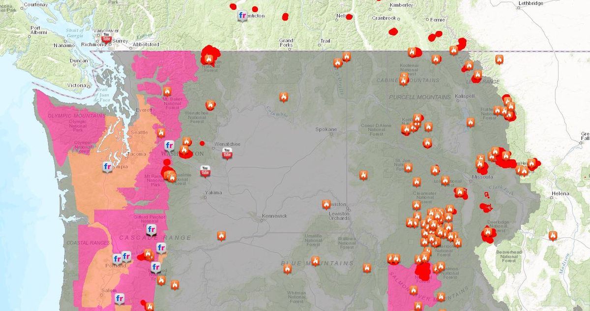
British Columbia-based Global News reported the Canadian province is in the midst of its worst fire season in history. The news station reported there are over 100 wildfires continuing to burn across the province, prompting mandatory evacuations for thousands of residents.
A provincial state of emergency has been extended for the fourth time until the end of day on Sept. 15.
The B.C. Wildfire Service has created a map of active wildfires, many of which are burning near the borders of Washington, Idaho and Montana.