Regaining power, Hurricane Irma expected to smash into Keys overnight
MIAMI – Slowed to a crawl by a violent encounter with the island of Cuba, Hurricane Irma nonetheless pressed on toward the Florida Keys Saturday night, with a landfall expected sometime Sunday morning.
Irma’s speed was cut in half and its intensity dramatically declined as it hammered Cuba, but the National Hurricane Center’s 8 p.m. advisory warned that the decline is only temporary.
“Irma is forecast to restrengthen once it moves away from Cuba and remain a powerful hurricane as it approaches Florida,” the advisory said. As its 7 mph speed picks up, Irma could cover the 110 miles to Key West in a relatively short time.
From there, it will take a north-by-northwest track up Florida’s Gulf Coast, the hurricane center said. Miami and Fort Lauderdale have likely escaped the worst of its wrath, but the Tampa-St. Petersburg area – which hasn’t suffered a direct hit from a powerful hurricane in more than 90 years – may not be so lucky.
And because Irma is so big, pushing hurricane-force winds outward up to 70 miles from the center and tropical-storm force winds to 195 miles, it can wreak considerable havoc in Miami-Dade and Broward counties, even from a distance.
A tornado was sighted in Oakland Park Saturday night, and the weather service issued tornado warnings for central Miami-Dade and western Broward. Miami-Dade Schools Superintendent Alberto Carvalho, visiting hurricane shelters located in his schools, warned residents against returning home.
“Despite the fact that we may not take a direct hit, the worst of the weather is yet to come,” he said. “Our advice is to stay put, stay where you are. Driving conditions are going to be bad.”
The same cautions surely extended into the Keys, where Marathon International Airport was already logging sustained wind of 48 mph and a gust of 67 mph.
While the forecast track shows the storm’s center crossing south of Big Pine, fierce winds and storm surge will likely be widespread.
Waters should begin rising between 8 p.m. and 2 a.m. overnight along the eastern side of the islands and from 8 a.m. to 2 p.m. on the west side, said hurricane specialist Mike Brennan. The surge could go as high as 10 feet throughout the Keys. From Card Sound Road to Miami Beach, a four- to six-foot surge is possible, he said.
Ed Rappaport, the acting director of the hurricane center, said Hurricane Irma’s impending visit to the Florida Keys and the state’s west coast is “capable of causing loss of life and major damage.”
The storm’s center has slowed to a crawl, an indication that it has begun its long-awaited turn to the north and the Florida Keys. Rappaport said the Keys can expect five- to 10-foot surges with waves atop.
Tampa’s storm surge could be between five and eight feet.
“We could see Irma back to a Cat 4 by the time it reaches the Keys,” said Rappaport.
He said the island chain can expect winds of 100 mph or more by daybreak.
Rappaport said the storm’s barometric pressure dropped slightly from this afternoon and its lack of forward motion meant the storm is adjusting and starting to head north.
As for the folks along the state’s west coast awaiting Irma, “I’m very concerned. They’re going to have a very rough 24 to 36 hours.”
Irma’s jog to the west caught much of the Gulf Coast by surprise. At midday Saturday, the plywood sheets and metal window shutters so ubiquitous in South Florida were still comparatively rare in St. Petersburg.
As for the Keys, their relationship with hurricanes is intimate and infamous, going back in recorded history at least to the early 17th century.
Over the past 100 years, the islands have been struck by a hurricane an average of one every 4.5 years – most disastrously on Labor Day weekend of 1935, when a nameless storm with 200 mph winds killed as many as 485 people and an entire railroad, the Keys extension of the Florida East Coast Railway, which was totally wrecked and never rebuilt.
The Keys were already taking punches from Irma on Saturday. Tropical-storm force winds pounded the islands, pushing storm surge ashore. Water levels were up throughout the day, rising nearly a foot above normal in Key West after 4:30 p.m. and more than a foot near Vaca Key.
The toll extended to many other areas of the state. Florida Gov. Rick Scott said in a news conference Saturday that 76,000 people were without power, and that the number of outages would only grow as the storm gets closer.
Irma has killed more than 20 people and left a wide swath of destruction as it smashed its way through Caribbean resort islands like St. Martin, St. Barts, St. Thomas, Barbuda and Antigua.
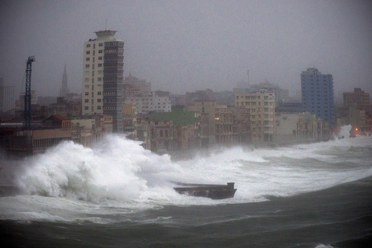
And little is known of the damage Irma did to Cuba, where it lingered much of the day Saturday. It struck the island as a Category 5 storm and moved away as a Category 3. It lashed the island with such fury that the government began moving people into underground military bunkers built decades ago when the Castro regime expected war with the United States.
But not much news has emerged since Irma reached Cuba. The national electric company announced that high winds were forcing it to cut power to Havana, and the Ministry of Communications said it was shutting down all public wi-fi receivers in the capital.