Getting There: Big changes coming to Bigelow Gulch Road
Orchard Prairie lies just east of Spokane, where Thomas and Margaret Doak planted apples trees in 1879, giving the rolling plateau its name.
It was here in Bigelow Gulch, a name nearly synonymous with Orchard Prairie and the neighboring Pleasant Prairie, where Father Joseph Cataldo purchased 1,000 acres from the Northern Pacific Railroad in 1882 and established a farm to provide produce and dairy products for the small school he was running on the Spokane River called Gonzaga College.
A few years later, in 1894, a two-room schoolhouse was built, Orchard Prairie School, that’s still in use today.
And there’s a road.
It’s unclear where the name “Bigelow” came from, but it attached itself to a gulch, and that gulch named the road. When Bigelow Gulch Road first appeared in the pages of The Spokesman-Review, it was for an improvement. The old dirt farm road traced the course of a gulch, perhaps, or maybe followed a long-used pathway of the people native to the area before white settlers arrived.
Either way, in 1937 the New Deal-era U.S. Works Progress Administration had money to spend to put Americans to work during the Great Depression. Spokane County’s road engineer, C.F. Griggs, proposed using some of that money to pave Bigelow Gulch Road using bituminous construction. The feds gave the go-ahead, local men joined the road crew and 77 miles of county roads – including Bigelow – were paved thanks to $378,000 in WPA money.
The quiet country lane’s future was laid with the pavement. With the WPA money came a new description of the road: highway.
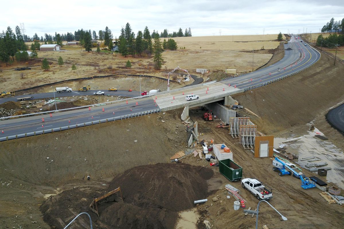
This week, a new $9.4 million interchange opens where Bigelow Gulch meets Forker Road, giving the road the character of a highway unlike it’s ever seen before. A curved overpass smoothly joins Forker to Bigelow Gulch, with four wide lanes, a median and large shoulders.
Say hello to the Bigelow Gulch Urban Connector. Or at least, the beginning of the connector.
While still four years from completion, this important segment officially opens tomorrow, the latest addition to the transforming road. This phase, one of six, has straightened and widened a mile or so of Bigelow Gulch Road, and the new overpass eliminates a dangerous blind intersection at Bigelow and Forker.
Overall, the $60 million “urban connector” project will remake the old two-lane country road, from one used by local farmers and their slow-moving machines to one used by commuters traveling between Spokane Valley, due north of the mall, and north Spokane, where it connects in Hillyard. When done, the road will be five lanes wide with eight-foot shoulders. Something like a highway, which is what the county’s considered it since WPA dollars paved it.
But right now, the eight-plus miles of the urban connector are a strange mishmash of skinny farmland roads and wide, freeway-like sections. It’s hard to see how the road will be made into one giant roadway, and it’s even harder to see how the two characters of the road – farm road and highway – can coexist for very long.
Regardless, the urban connector has been envisioned for years, and there have been many arguments to justify its construction, ranging from a desire to have a “beltway” north of town, to concerns about safety, to coming up with an alternative to the north-south freeway, which seemed like it would never be built when the county approved the project in 1999.
“The winding paths of Forker and Bigelow Gulch roads are farm routes no longer,” read a January 1999 article from The Spokeman-Review. “For years, Pleasant Prairie farmers puttered along with machinery and equipment. As time wore on, the roar of passing semi-trucks and commuter traffic became more common than the chugging of tractors. That roar could soon become louder.”
The plan wasn’t universally accepted. At the time, Alex Wood was serving as a Democratic member of the state House representing Spokane’s Third District. He suggested the expansion of Bigelow would impede plans to finish the north-south freeway. Unlike today, when the North Spokane Corridor is halfway built and fully funded, two decades ago the freeway seemed very far from completion.
“We don’t want to show a split because we’re trying to get money for the north-south freeway,” Wood told the paper, noting that the urban connector plan was a good idea, but that the Bigelow Gulch corridor should be worked in as part of the North Spokane Corridor.
Some residents of the various prairies overlooking the city – including Orchard, Pleasant and Peone – began to organize against the road, while others welcomed any changes that would improve safety.
The opponents focused on unfair land acquisitions and a desire to retain neighborhood character. Drive there today, and you’ll see what they’re talkinga bout. Private land goes right up to the skinnier parts of Bigelow Gulch, and historic farmhouses dot the landscape.
The gratitude that came with the Depression-era pavement had waned well before the urban connector was proposed, but the underlying issues remained the same. In 1979, for instance, locals formed the Committee for the Preservation of Orchard Prairie to stop “the encroachment of industrial and commercial development in our community.”
But proponents of improvements on Bigelow had a stronger argument, one that dealt with safety. The tiny two lanes were just fine for combines and slow-moving trailers, but they didn’t suffice for the growing ranks of motorists taking the far-flung route, at times to lethal effect.
In 1996, more than 13,000 cars traveled Bigelow Gulch between Market Street and Argonne Road each day, according to county figures. On that same stretch between 1991 and 1995, there were 175 car wrecks, one that led to the death of an Otis Orchards teenager in October 1995.
Though the number of vehicles didn’t grow that much – from 13,000 a day to 16,000 a day over the next decade, where it’s leveled-off – the fatalities continued. From 1997 to 2017, there were five fatal collisions on the corridor between Havana and its eastern terminus at Progress Road. Another 283 collisions led to injuries.
The cars were there in dangerous numbers. Short of stopping people from using the road, county engineers figured the only solution was to make it straighter and wider.
Though the interchange is open, the road is far from complete. In fact, large stretches of Bigelow Gulch look something how it probably looked when the WPA finished its work.
But in 2022, the county says, the urban connector will be complete. And seven years later, in 2029, the North Spokane Corridor will be done. The two will meet at Francis Avenue. From that joining of free-flowing roads, motorists will have numerous options to get around, and quickly. Head south six miles on the north-south freeway to meet Interstate 90. Or head east on the urban connecter for 13 miles to meet I-90. Do one big loop on the roads, with Millwood at their center, and revel in Spokane’s predilection for building highways in the 21st century.
Finally, watch the rural land of Orchard Prairie urbanize. It is called the urban connecter, after all, and it’s already happening. Between the farmhouses and wheat fields, new mansions stand sentry, waiting and watching for the orchard’s future as a suburb. Just think of how the rural areas in northeast Spokane will look in coming years, with the arrival of the Bigelow Gulch Urban Connector and the North Spokane Corridor. These new roads will shrink the time it takes to commute from there to just about anywhere, encouraging new developments to spring up.
It’s hard to blame the people who want to move there and build a home of their dreams just a 20-minute drive from downtown. But it’s hard not wonder if the apple trees of Orchard Prairie will be like the orange groves of Southern California, where the only remnants of Orange County’s namesake citrus are a few shrinking groves and the scent sprayed on visitors to Disney California Adventure Park.
Got a transportation question or story idea? Write to nickd@spokesman.com.
Sharp open
After a full construction season of decimated roadway, Sharp Avenue between Pearl Street and Hamilton Street is open, the latest example of the city’s efforts to treat stormwater on-site and divert it from the overburdened infrastructure of pipes and water treatment plant.
The $2 million project completely reworked the road, putting new landscaped swales in the center of the road, where rain water will be shuffled.
Some of Sharp’s blocks are now made with porous asphalt, allowing rain water to seep through the road and enter the earth below. It’s a new method of treating stormwater on-site, allowing the dirt below to “bio-filter” the water before it reaches the river and aquifer, our sole source of drinking water.
Some of the street’s parking bays will be made of porous concrete, and bike lanes have been added to the street, which runs in front of Gonzaga University. Students from Gonzaga helped do research for this construction project.
Mission Avenue lane closures for Centennial Trail
Phase one of the Centennial Trail Mission Avenue Gap project will close the center eastbound and westbound lanes of Mission for work on the traffic island. The right lane of south-bound Perry Street is closed from Indiana to Mission.
The $500,000 project has also detoured the Centennial Trail in order to get pedestrians and bicyclists around the construction
The project is adding better sidewalks and traffic islands on Mission at Perry, and improving the parking lot at the Witter Aquatic Center to include a bus turnaround and new lighting.
Public meeting for changes on U.S. Highway 2 in Colbert
The Washington state Department of Transportation is holding a meeting Thursday from 6 p.m. to 8 p.m. at Mountainside Middle School, 4717 E. Day Mt. Spokane Road in Colbert, to discuss changes at the intersection of U.S. Highway 2 near Colbert Road.
Three recent crashes at the intersection have led to concerns about collisions and safety. Representatives from the WSDOT, including the traffic manager, project engineer, planning manager and the regional administrator, will provide background on the intersection and discuss how the projects are prioritized and funded.
Grind and overlay hits Washington Street
Beginning today through Thursday, the city’s street department will be working on a grind and overlay maintenance project on Washington Street. The work will close one lane at a time between Spokane Falls Boulevard and the north side of the tunnel under Riverfront Park.
Crews are also out in neighbors doing grind and overlay on residential streets:
- Dalke Avenue from Monroe to Wall Street
- Lincoln Street from Central to Francis Avenue
- Post Street from Dalke to Francis Avenue
- Addison Drive from Standard to Dakota Street
- Dakota Street from Addison to Cozza Drive
- Wedgewood Avenue from Standard to Dakota Street
- Mayfair Street from Queen to Rowan Avenue