Forecast is hot and hazy early this week as crews battle large wildfire on Colville Reservation
Spokane got its first whiff of the 2019 wildfire season Saturday night, and wind is expected to continue to bring widespread haze south from a wildfire on the Colville Indian Reservation in the evenings early this week.
The city should also see the hottest days of the year so far Monday through Wednesday, according to National Weather Service forecasts.
Extreme weather is also the cause of the wildfire to the northwest, called the Williams Flats fire. Lightning struck the ground southeast of Keller as a thunderstorm rolled through the region early Friday morning, said Elizabeth Shepard, fire spokeswomanfor the Northwest Interagency Coordination Center.
The area was logged five years ago, leaving behind slash, along with grass and brush, to fuel the fire.
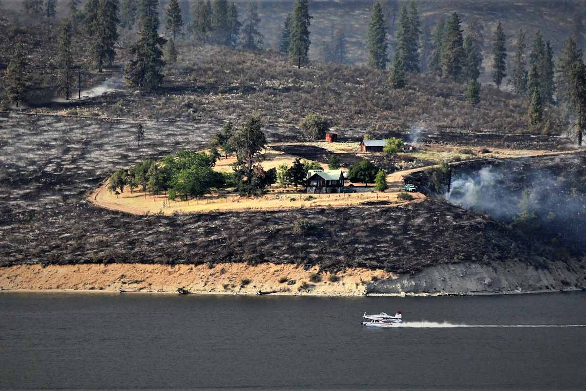
Wind speeds between 16 and 22 mph, with gusts up to 28 mph, Friday afternoon and early evening helped the fire jump a containment line at Brody Creek Road. From there it spread east from its initially reported size of 400 acres to 10,438 by 5 p.m. Sunday.
More than 260 personnel are on the scene, but steep terrain and primitive roads have made the blaze difficult for crews to access and attack.
“You know the terrain is steep when you have mountain goats in the area,” Shepard said.
Six helicopters have dropped water from Lake Roosevelt on the fire. Officials have been patrolling the recreational area to keep boaters away as aircraft gather water.
Somewhat moist fuels and less severe winds have made the fire more manageable as additional resources have arrived, Shepard said.
“It’s just moving along and finding receptive fuels and burning,” she said. “We’re really waiting for that place where we can stop the progress of the fire.”
Only one residence is under a level 2 evacuation order, under which occupants are told to be ready to leave, but the home south of the fire was empty and firefighters have dug a full line around it. Kuehne, Frielander and Canteen Creek roads are closed, along with other roads that have access to the fire.
Crews worked Sunday to dig containment lines and solidify the southern perimeter of the fire.
Firefighters are also concerned about the possibility of other embers created by lightning strikes in the area turning into larger fires if the wind picks up. But lately it has been calm in the fire area, Shepard said.
Smoke from the fire rolled into the Spokane area late Saturday afternoon and brought the air quality to unhealthy levels at times until 5 a.m. Sunday. The air was healthy in Spokane during the day and winds were not forecast to bring haze to the area Sunday night.
The Moses Lake and Ritzville areas will see the brunt of the haze Sunday night, according to forecasters. Ritzville, Moses Lake and Quincy had air-quality levels worse than healthy Sunday afternoon.
Spokane is forecast to see more haze and smoke Monday afternoon when the wind changes directions, Spokane meteorologist Laurie Nisbet said. The Spokane Regional Clean Air Agency forecast moderate air quality in the city for Monday.
The National Weather Service also projects Monday to be the hottest day of the year so far at 95 degrees. The previous high was 94.
After Monday, there is no haze projected for Spokane and no concern of fire-causing weather.
“There’s nothing we’re looking at in the next three days of concern,” Nisbet said. “It’s just going to be hot and dry.”
Tuesday could bring record-breaking heat with a high of 97 degrees. The hottest Aug. 6 on record was in 1972 when it reached 99 degrees. It is projected to be just as hot Wednesday, but the record for that day is 101.