Weathercatch: Grateful for no ‘bomb cyclone’ this holiday
A year ago today, more than a thousand people bundled up to brave cold temperatures and winds at the annual Thanksgiving Day Turkey Trot in Spokane. As runners and walkers congregated at the starting line, the temperature was 25 degrees. With winds gusting up to 38 mph, the windchill “feels-like” temperature made it seem even colder.
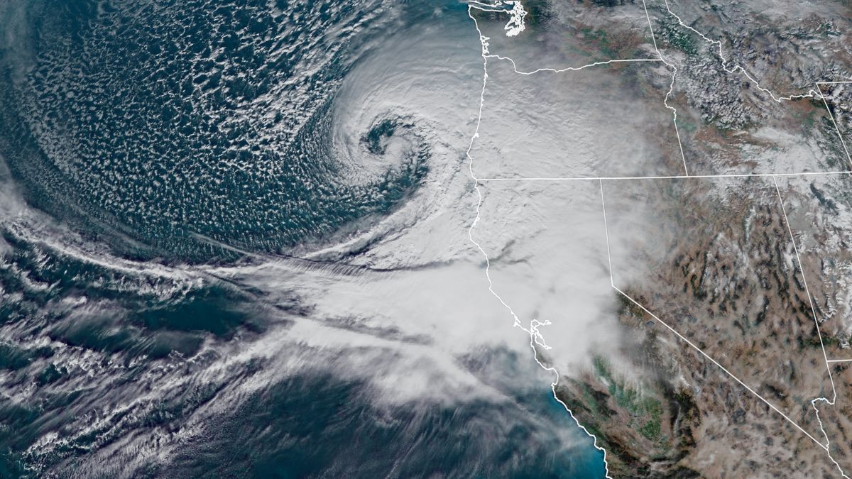
It’s remarkable to think that those brisk weather conditions were an offshoot of an “unprecedented” storm system that had crashed ashore 630 miles away less than two days earlier. Known as a “bomb cyclone,” it made landfall on the Oregon-California coast on the afternoon of Nov. 26.
“This is an unprecedented storm given its track and strength and will cause very dangerous conditions to the area,” the National Weather Service in Medford, Oregon, posted that day.
And indeed, it was a big one. Sustained winds of 85 mph were measured at Cape Blanco, Oregon, with gusts reaching 106 mph. The storm system also spawned some of the tallest waves ever recorded off the California coast, including a gigantic 75 foot wave 20 miles off Cape Mendocino.
As the storm trekked eastward, weather watches, warnings and alerts riddled the western half of the U.S. From Nov. 26-29, temperatures plummeted, winds howled and heavy precipitation fell as snow or rain. Hardest hit states included Oregon, California, Nevada and Colorado. It also packed a punch in southern Idaho.
As millions of Americans traveled for the Thanksgiving holiday, the potent storm caused flash floods, power outages, numerous road closures and flight cancellations. Washington state avoided the brunt of storm’s fury by being north of the storm’s trajectory. Even so, its impact was felt statewide. Seattle experienced a small but rare thunderstorm. Wenatchee saw wind gusts of 48 mph. Spokane got a 0.6 inch of snow and temperatures ran about 10 degrees below average and even more with the wind chill factored in.
From Oregon to Nebraska, this so-called bomb cyclone whipped up a lot of trouble.
Storms are sometimes over-hyped in the media, so you might be wondering if the bomb term is based on actual science or clickbait hoopla. The ominous word is in fact a real deal that’s been in use for 40 years. A nontechnical term for a weather system known as bombogenesis, it was coined by two atmospheric science researchers at the Massachusetts Institute of Technology in a widely cited paper published in 1980.
Basically, a bomb cyclone occurs when a warm air mass collides with a cold air mass – often over ocean waters – resulting in the rapid drop of air pressure. As the two masses converge, winds rotate faster and faster as a mid-latitude cyclone. Typically, the faster the air pressure drops, the stronger the storm.
Before the bomb cyclone lashed the Pacific Coast last November, it intensified so rapidly that its development broke records for California and Oregon.
The storm system’s barometric pressure dropped 48 millibars in 24 hours – that’s double the National Oceanic and Atmospheric Administration’s requirement of 24 millibars in 24 hours to classify as a bomb cyclone.
As we said, it was a big one. Not only that, but its arrival during the busiest travel time of the year compounded the storm’s impact.
So the term isn’t an exaggeration; these weather systems develop rapidly and explosively. Fortunately, most don’t reach the level of intensity as the one that carved across the West a year ago. Even so, it’s not uncommon for them to generate destructive winds and heavy precipitation closest to the region where they formed.
On this Thanksgiving Day, the weather is much calmer than a year ago. And the annual Turkey Trot is different as well. Due to the COVID-19 pandemic, a virtual version of the race is being held instead, where participants run or walk their own routes at unspecified times. Unlike in 2019, they won’t have to contend with big wind gusts and frigid temperatures. Gone with the wind chill are parkas and stocking caps.
— Nic Loyd is a meteorologist in Washington state. Linda Weiford is a writer in Moscow, Idaho, who’s also a weather geek. Contact: ldweiford@gmail.com