Weathercatch: March’s last hurrah – high winds, blowing dust and air-borne trampolines
As we say goodbye to March 2021, it’s safe to say that its weather will be most remembered for the end-of-the-month windstorm that hurled everything from howling winds and blowing dust to rain, hail and snow.
And don’t forget about the plunging temperatures and flying trampolines.
Triggered by a large-scale cold front that dropped southward from Canada, the boisterous spring storm began its trek across Washington state on Sunday morning, building strength as it moved eastward toward the Inland Northwest. It arrived midafternoon, making the most commotion between 3 and 8 p.m.
On Facebook, residents of Eastern Washington and North Idaho spoke of darkening skies caused by blowing dust, trees falling on lawns and across roadways and tossed-about patio chairs and airborne trampolines landing in fields and neighboring yards.
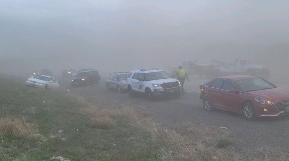
“There are several areas with extreme blowing dust and limited visibility,” the Walla Walla County Sheriff’s Office said in a post.
“To avoid the Wicked Witch of the West, please slow down, use your lights and avoid driving if possible,” the post said.
Those who did drive experienced white-knuckle conditions on a number of roadways.
In Richland, a seven-vehicle chain reaction crash occurred amid blowing dust on Interstate 182 shortly after 3:30 p.m., according to the Washington State Patrol. Also, Interstate 90 was closed in both directions from Ritzville to Moses Lake after high winds and blowing dust created “near zero visibility,” the Washington State Department of Transportation warned in a Tweet.
Heavy winds also knocked out power to thousands of customers in the Inland Northwest. Avista Utilities reported more than 11,000 customers were in the dark Sunday night, while 2,700 customers lost their electricity with Inland Power and Light Co. and 3,000 with Kootenai Electric Co-op.
Some of the strongest winds were recorded near Coeur d’ Alene, where gusts surged to 64 mph in Athol, according to the National Weather Service. At Spokane International Airport, sustained winds topped out at 43 mph, with gusts reaching 53 mph just before 4 p.m. Meanwhile, peak gusts reached 63 mph at Tri-Cities Airport at 6:40 p.m.
But wind was only part of the problem. The storm unleashed another round of winds in the evening that brought spitting rain, hail and snow. The region also experienced a steep temperature plunge. Where high temperatures ran close to 60 degrees on Sunday, we awoke to a raw air mass of 27 degrees in Spokane on Monday morning. Communities such as Moscow-Pullman and Palouse received a half-inch of snow overnight. Tuesday morning was even chillier, with temperatures across the region ranging from the upper teens to mid-20s.
The cold front that sloped in from the northwest was the main driver of the vigorous storm that quieted down by Monday but replaced spring with winter. However, another key factor was a significant air pressure gradient, or air pressure change, caused by a strong high-pressure system over the Pacific Ocean that squared off with a potent low-pressure system over Alberta, Canada. As the air moved from high pressure to low, it began its rapid slide toward Washington, ramping up speed and delivering an influx of cold air as it moved across the Cascade Range.
By midweek, a strengthening ridge of high pressure bumped our temperatures back up into the low 60s under mostly sunny and calm skies. The warmest weather is expected today. But pleasant conditions should continue into the weekend with breeziness, partly cloudy skies and temperatures in the high 50s to low 60s.
———
Nic Loyd is a meteorologist in Washington state. Linda Weiford is a writer in Moscow, Idaho, who’s also a weather geek. She can be reached at ldweiford@gmail.com.