Weathercatch: Dust-filled drama of past teaches lesson for future
Seven years ago today, a monster wall of dust barreled across parts of Eastern Washington and North Idaho, turning skies brown, causing power outages and triggering a six-vehicle pileup.
And though we see plenty of dust storms in the region, this one was of a different league.
It was a haboob (pronounced hah-boob), an Arabic term for a massive sand or dust storm rising a half-mile or more in the sky and traveling great distances. Formed by winds rushing outward of an advancing thunderstorm, these eerie spectacles are fairly common in the driest corners of Arizona, New Mexico and parts of the Middle East and Africa. But not here in the Inland Northwest.
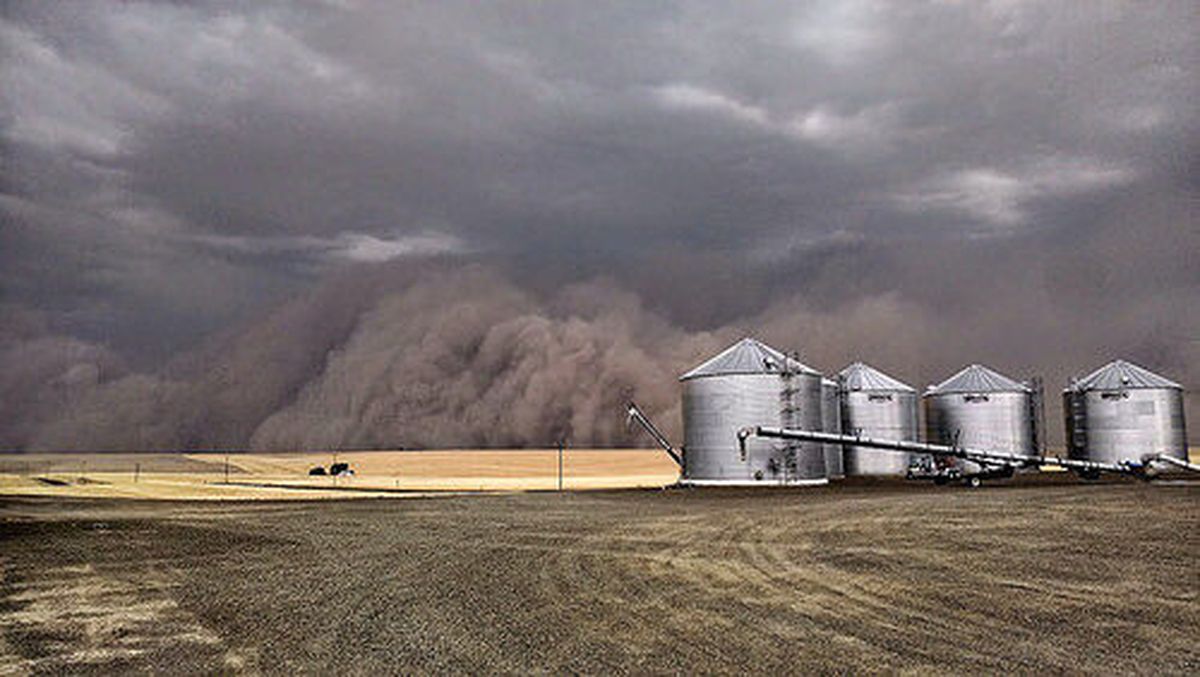
Shortly before 3 p.m. on Aug. 12, 2014, an approaching thunderstorm kicked up dust and dirt and pushed it forward into a wall-like front carried by the wind. Moving like sandblast, it shrouded the sun and obscured everything from trees and barns to moving vehicles, according to reports.
The Arizona-like haboob began tracking across parts of Adams, Whitman and Garfield counties, south of Spokane. Along the way, it knocked down trees and power lines and contributed to numerous traffic accidents. The most serious occurred on Interstate 90 west of Ritzville where five people were injured in a six-vehicle collision.
“It lowered visibility to near zero,” the National Weather Service of Spokane reported, adding that winds of 60 mph and higher were associated with the system.
After the haboob and its subsequent thunderstorm swept through, about 10,000 customers had lost power from south of Spokane to the Palouse area and into Idaho’s Grangeville County. The county fair in Moses Lake was temporarily canceled due to winds and dust .
Why did it happen and what made it a haboob rather than a dust storm?
The American Meteorology Society defines a haboob as an intense wall of dust caused by strong winds lofting the dust as high as 5,000 feet. That summer had been persistently hot with little rain, making dry soils and recently harvested fields ripe for a dust-up. Along came the advancing thunderstorm and the sudden rush of winds stirred up the giant wall of dust.
“The leading edge of the haboob was about 4-5 miles ahead of its parent thunderstorm at its prime,” the National Weather Service of Spokane wrote in a tweet.
Haboobs tend to be more intense and towering than dust storms. They also impact visibility more drastically. And while a haboob is kicked up by upper-air outflow from a thunderstorm, a dust storm is triggered by surface winds closer to the ground.
Both can cause very dangerous driving conditions. Stay out of harm’s way by not driving into an area of strong blowing dust. Visibility can quickly drop to zero, leaving you and everyone else on the road driving blind.
Should you ever get trapped in a haboob or severe dust storm, the Arizona Department of Transportation – whose slogan is “Pull Aside, Stay Alive” – advises you to slowly pull off to the road’s shoulder, put the parking brake on and turn off all of your vehicle’s lights – including emergency flashers. This is to prevent motorists approaching from behind to become disoriented and follow your lights, inadvertently crashing into your car.
———
Nic Loyd is a meteorologist in Washington state. Linda Weiford is a writer in Moscow, Idaho, who’s also a weather geek. Contact: ldweiford@gmail.com