Smokier conditions in Spokane as red flag warning creates potential for new fires nearby
Get used to the hot and moderately smoky conditions that hit the Spokane area on Monday because a red flag warning until Wednesday means that smoke and wildfire concerns aren’t going away.
Smoke from the massive 300,000-acre Bootleg fire in southern Oregon and from smaller fires in southeast Washington rolled into Spokane on Monday, bringing air quality levels to the moderate range, according to Spokane Regional Clean Air Agency.
Based on wind trajectories, the fire is likely why some areas of Spokane on Monday saw ash falling from the sky, said Charlotte Dewey, meteorologist for National Weather Service Spokane. She said falling ash is common with numerous wildfires in the area.
As of 4 p.m. Monday, the National Weather Service had reports of ash in the Eagle Ridge area, while Dewey said meteorologists also observed ash near their office north of Spokane International Airport.
“Unfortunately, it got thicker than we originally anticipated,” Dewey said of Monday’s smoky conditions. “Some of the fires have behaved more erratically and produced more smoke than our models originally forecasted.”
Moderate air quality means that the air is generally acceptable; however, for some pollutants there may be a health concern for a very small number of people who are especially sensitive to air pollution.
The haze that has enveloped Spokane is expected to stick around until at least Wednesday, according to the National Weather Service Office in Spokane. Temperatures will also hover around 90 degrees through Wednesday.
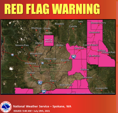
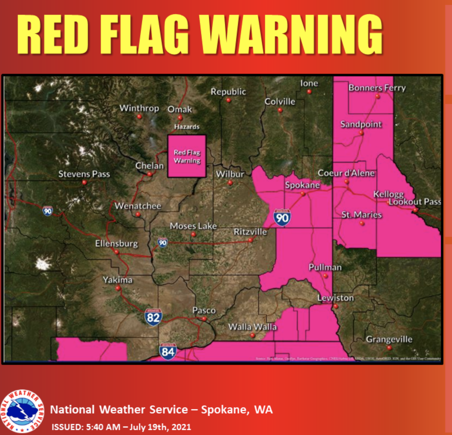
The wildfire season will have potential to ramp up this week as the weather service declared a red flag warning for parts of Eastern Washington and all of the Idaho Panhandle starting at 1 a.m. Tuesday through noon Wednesday. The Spokane area runs the risk of fast-moving, dry thunderstorms through early Wednesday. With little precipitation, these thunderstorms could result in new fires in the Spokane area, according to NWS Spokane.
Thunderstorms could also bring strong, fire-worsening winds.
“These storms could bring gusts up to 30 mph,” said Valerie Thaler, a meteorologist at NWS Spokane.
Outside of the thunderstorms, winds are forecast slower than 10 mph on Tuesday. But stronger winds in excess of 10 mph could occur on Wednesday with gusts reaching 21 mph.
Firefighters working across the state will be busy with potential for new wildfires and existing ones getting worse.
There are two major fires, including the 71,512-acre Lick Creek fire in southeastern Washington, which is 40% contained, and the 35,591-acre Chuweah Creek fire near Nespelem, now at and 35% containment.
There are numerous other wildfires in Washington, including a 8,255-acre fire in Okanogan County near Cub Creek that started Sunday, according to the Okanogan-Wenatchee National Forest Service.
And there are numerous wildfires in North Idaho of 1,000 acres or more.