In North Cascades, researchers, climbers watch Washington’s snowpack quickly melt, exposing glaciers’ retreat
SEATTLE – From year to year, no two steps on a glacier remain the same, for it is a landscape ever changing.
Beneath your boot, after all, is a frozen river, inching downhill, slowly pushed by gravity, though subject to the occasional snap as ice strains and cracks beneath its own weight.
Feet of snow can pile up by the dozen during Cascade range winters – millions of snowflakes, of all shapes and character, settling atop blue ice.
Washington has the most glaciers of any state in the Lower 48. These frozen reservoirs of freshwater keep alpine streams flowing through summer, cool the rivers for salmon making their seasonal spawning journeys and provide humans drinking water and hydropower.
Glaciers of the past carved Washington’s landscape. They gouged out Lake Washington and molded Seattle’s steep hills. On clear days, Mount Rainier’s ice still dominates the skyline, reminding those of us sipping lattes in skyscrapers that rugged forces still shape us.
But Northwest glaciers, shrinking, receding and collapsing, are on a climate-change driven path of decline.
It’s been a strange year in Washington. A hearty snowpack blanketed the Cascades, but then March and April were the fourth-driest on record in Washington, according to the state Ecology Department. May brought some moisture, but then a record heat wave, which experts considered nearly impossible if not for climate change, seared the state in late June.
The weather station near the Paradise Visitor Center on Mount Rainier, which is at 5,400 feet elevation, reached 91 degrees on June 29. Over five days, the heat sliced the snowpack in half, shedding more than 2½ feet of depth.
As someone who writes often about climate change and spends free time mountaineering, I was left with questions during a July climbing trip.
Over 21 miles and several glaciers, I found dry forests, bare glacial ice and conditions I would have expected later in the season.
What does a season like this mean?
Veteran climbers say this year felt like another example of a shift in the mountaineering season with once-reliable routes becoming more complicated.
For scientists, the evidence remains incomplete. The bare ice, historic heat and raging streams are clues, but the season isn’t over and the impacts can’t be assessed until the measurements are due.
The long-term trend has researchers wondering about the future.
Mauri Pelto, who has monitored eight Northwest glaciers since 1984, estimates the North Cascades have lost 25-30% of their mass since his studies began and the decline has accelerated.
“At this pace, very little’s going to be left by even 2075, but they won’t all be gone,” Pelto said. “It’s a brutal reality.”
A land of endangered glaciers
In late July, a journey into a remote portion of the North Cascades brought me into terrain with glaciers now among those most endangered.
During the four-day trip, we traveled about 21 miles, 18 of them through rugged, tedious terrain without trail.
For my wife and me, it had already been a strange climbing season.
During the heat wave, we roasted in the sun on a climb of Ingalls Peak. Two weeks later, we decided to forgo a planned climb of Mount Rainier’s Emmons Route after the heat wave led climbing rangers to describe conditions as “unsupportable” and “punchy” with up to a dozen climbers falling partially into crevasses. Two climbers fell in completely and needed rope partners to perform rescues with pulley systems, according to a blog published by climbing rangers.
The route – typically reliable in July – wasn’t impassable. But it wasn’t in the right condition for us, we decided. We gave the Disappointment Cleaver route a shot that weekend instead, before a bout of altitude sickness turned us around.
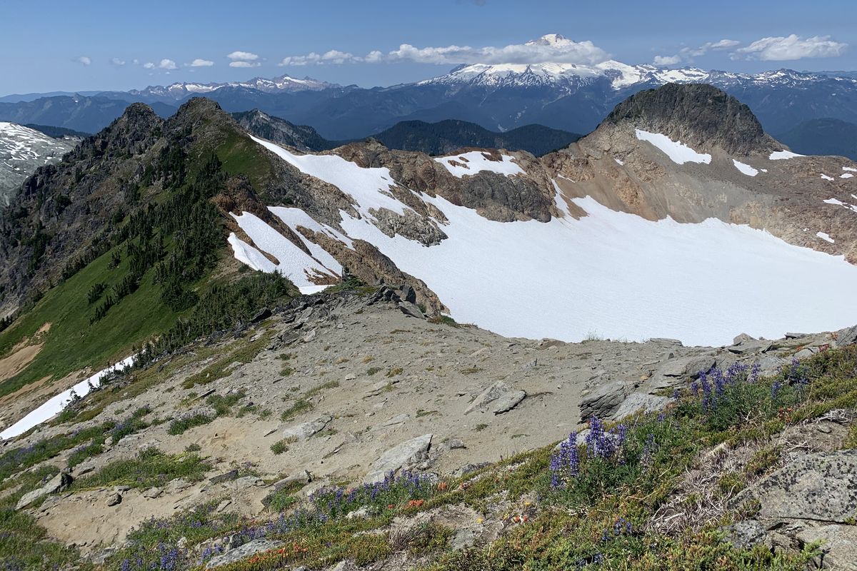
Our long traverse during the final week of July required us to summit Bacon Peak, a broad glaciated massif in Washington’s North Cascades, and then skirt past Hagan Mountain and Mount Blum before descending to Baker Lake.
The trip threw a bit of everything at us: We traversed snowfields, bushwhacked through brushy slide alder, scampered up alpine meadows, saw a bear cub, scrambled up steep rock, crossed glaciers and climbed up steep snow while plunging ice axes into the slope for security.
In the forest, legions of mosquitoes attacked. After hundreds of bites, our shoulders looked like raised topographic maps.
The scenery was stunning, but it looked closer to what I would have expected for September. Snowfields prominent on the topographic maps we’d studied in preparation were smaller than advertised. Patches of bare, blue glacial ice dotted the landscape. In lowland forest, moss remained so dry it crumbled in our hands.
More experienced backcountry travelers took similar seasonal notes.
“It’s definitely pretty remarkable how bare that mountain looks like right now,” mountain guide Martin Volken said about nearby Mount Baker in early August.
Volken, who owns Pro Guiding Service in North Bend, Washington, recently recounted leading a guided trip on that mountain’s Coleman-Deming Route during the June heat wave. It felt like he was inside an air conditioner, he said, and “there were creeks running on top of the ice.”
In early August, the summit – and the steep head wall guarding it, called the Roman Wall – now looks “almost unrecognizable,” Volken said. Where there was once snow, “strange mudflows” have developed. “Patches of the glacier now are just gone.”
Volken, a licensed guide since 1996, said it used to be that Mount Baker could be climbed nearly year-round by mountaineers familiar with roped glacier travel and the use of ice axes and crampons.
“It might be firmer or icier, but you climb it until the snow comes back,” he said.
He fears that’s changing.
“It’s a new world here in the North Cascades,” Volken said. “It seems like the mountaineering season is shifting to a month earlier.”
Our observations are anecdotes, of course, not data-bound scientific evidence.
Maps of perennial snow or ice aren’t always reliable, said Jon Riedel, a National Park Service geologist who is retired but remains active in research. Dark, bare glacial ice can result from avalanches or scouring winds rather than rapid melt. A single heat wave does not define a season.
“We won’t really know what this year is like until we do studies later,” said Scott Beason, a geologist at Mount Rainier National Park.
Clues of glacial health
There’s little doubt the heat wave prompted rapid melt.
The weather station near the Paradise Visitor Center on Mount Rainier measured about 60 inches of snow depth on midnight June 25. Three days later, on June 28, it had dropped to about 33 inches.
“It was four to five times faster melt than what we’d really seen” earlier in the summer, Beason said.
Streams ran high and filled with sediment, giving them a “chocolate milk color,” Beason said.
In the North Cascades’ Thunder Creek watershed, the most glaciated watershed in the Lower 48 states, stream flows reached their summer peak on June 28, at the height of the heat wave, due to sudden snow melt.
Snow acts as a buffer to prevent glacial melt.
“Snow tends to be brighter – more white – and it reflects more of the incoming solar radiation,” said David Shean, a University of Washington professor who studies glaciers. Glacial ice, often dark and blue, “will absorb more sunlight and the ice will melt more rapidly than when covered.”
Volken likens it to a layer of sunscreen. Wipe it off and the glaciers are more likely to feel the sun’s consequences.
Debris within glaciers can amplify or dampen this effect, Beason said. Sand, gravel and boulders within glaciers can absorb solar radiation and intensify melting. A thick layer of debris – say 2 inches thick– can also insulate glaciers.
Snow that remains throughout the summer – typically at high elevation – will feed the glacier into next year.
Scientists visit more than a dozen glaciers in the Cascades each year to take their measurements and monitor their “budget,” the seasonal accumulation and loss of snow and ice, whether from melting, wind or avalanche.
“It’s like balancing a checkbook,” said Caitlyn Florentine, a U.S. Geological Survey scientist who measures the South Cascade Glacier, which is just north of Glacier Peak and has been monitored since the late 1950s. The glacier has declined for decades.
A glacier’s rapid decline
During our late July traverse, we skirted past the Noisy Creek Glacier, a hulking mass of ice that once measured 400 feet thick, but is thinning and collapsing, researchers say.
National Park Service scientists have been monitoring Noisy, and three others, since 1993.
Each year, field crews visit three times – once at the height of the snowpack in late April, when there’s often 25 feet of snow. Then, they hike up in summer, and again in fall for final measurements.
The scientists probe into the glacier to measure its depth. In spring, they use a steam drill to install ablation stakes, which help track the pace of its melt and seasonal change in mass.
There are worse places to work, Riedel said.
A “layer of frosting” coats the remote landscape each spring. Mount Shuksan – said to be one of the most photographed mountains in Washington – dominates the view. Snow dampens sound and hushes the landscape, though that’s “punctuated” by the occasional avalanche.
The lowest of four glaciers that Riedel and the Park Service survey in the North Cascades National Park, Noisy once relied on the massive snowfall common to the west side of the Cascades to bulk up each season and make up for its elevation at 5,800 feet.
The glacier has been declining persistently, and it’s not just warmer summers driving that change.
A snowpack drought in 2015, a year some climate scientists view as a harbinger of our region’s climate future, “hammered” the glacier, Riedel said, because an outsized amount of precipitation fell as rain.
Riedel said it takes a snowpack at least 130% above average to have a chance at a positive balance when the accounting is complete. He doesn’t expect this past year’s snowfall to have been enough.
“This year, the heat dome was unprecedented. What that week did was cut into the winter snowpack,” Riedel said. “We won’t know, until we get the final measurements at the end of September, just how dire it’s been.”
Bedrock protrudes from the glacier and it has begun to collapse. If trends continue, the glacier he’s visited for 28 years could be gone in a few decades, Riedel said.
“In hindsight, maybe I shouldn’t have selected Noisy. I didn’t expect it to go so fast.”
Decades of shrinking expected
The story of the Noisy Creek Glacier is playing out throughout the North Cascades where glacial ice loss is accelerating, according to Pelto, the Nichols College professor who directs the North Cascades Glacier Climate Project.
Of the eight glaciers he studies, “it’s been a decade since we’ve seen a year in which they’ve really gained mass.”
During his regular field season, in which he once mainly wore skis to travel across snow, Pelto now wears crampons instead to keep solid footing on ice.
Some of climate change’s impacts – including many of the most dire effects – are reversible if the world rapidly reduces greenhouse gas emissions, according to the United Nations Intergovernmental Panel on Climate Change.
That’s not the case for our retreating glaciers, which won’t respond quickly to emissions changes.
“Because glaciers act like conveyor belts, there can be a lag in their geometric response to climate,” Florentine said. “Even if we were to turn climate warming off today there still would be some amount of committed retreat for glaciers on our planet.”
Pelto said glacial response varies but has been observed in the North Cascades to be between 10 and 30 years.
Northwest glaciers at high elevation, such as those on Mount Rainier or Mount Baker, could fare much better overall. Florentine said our emissions will drive the timing and magnitude of loss.
“The mountains will still be there, but they’re going to be missing a critical element of what’s made them special,” Pelto said.
•••
On the final evening of our July traverse, our group of four was bushed. Three 12- to 14-hour days of routefinding, voracious mosquitoes and thrashing through tree branches had taken a toll. At the time, it wasn’t a trip I was feeling eager to repeat.
At camp, we laid out in the sun on sparkling granite rock slabs, dipped our raw feet into cold, flowing snow melt and attacked our bagged, dehydrated meals. We scattered our gear, wet from crossing several glaciers, out to dry.
As the sun set, Mount Baker stood tall on a horizon blanketed in a tangerine and honey-hued haze, likely from wildfire smoke.
Ice on the Talum, Boulder and Park glaciers, wrinkled with crevasses, flowed down the broad volcano.
It was a breathtaking sight I recognized might not last forever.