Strong winds, colder temps and possibly more snow expected this weekend
The Inland Northwest can expect strong winds over the weekend followed by freezing temperatures next week as an active weather pattern moves into the region, according to a National Weather Service briefing.
National Weather Service meteorologists urged residents to prepare for possible power outages.
The abrupt beginning of winter weather follows the warmest October in Eastern Washington on record.
The Spokane metro area was expected to get between 2 to 3 inches of snow by Friday morning, the weather service said. The snow was expected to give way to rain on Friday morning, making for a potentially slushy commute, meteorologist Laurie Nesbit said. Areas in higher elevations in northeastern Washington and in the Idaho Panhandle were expected to get 4 inches or more, which likely will hang around longer than in Spokane, she said.
More snow could hit again on Sunday as temperatures begin to drop, said meteorologist Steve Bodnar, also with the National Weather Service.
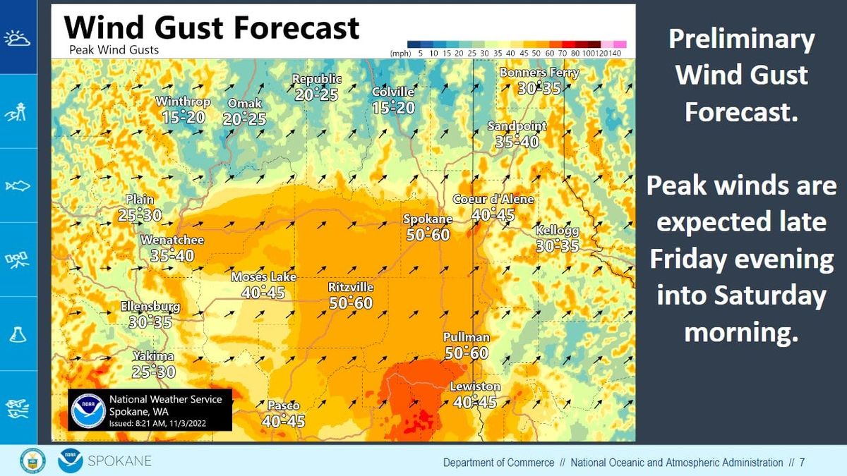
Strong winds Friday and Saturday
Winds are expected to increase on Friday evening in the Columbia Basin, Palouse and Spokane area between 15 to 25 mph with gusts between 25 to 35 mph. The winds are expected to be the strongest between 10 p.m. Friday and 5 a.m. Saturday, bringing sustained winds between 15 to 35 mph and gusts of 50 to 60 mph.
National Weather Service meteorologist Jon Fox said that the wind storms could be similar to events in Spokane in January 2021 and November 2015, which saw gusts that reach 71 mph, the strongest wind recorded in Spokane not during a thunderstorm. Those events were historically damaging and were among the strongest winds ever reported at the Spokane airport, he said.
Fox said this weekend “the impacts could be the same if not more just because of all the vegetation on the trees.”
Tree branches are still “fully leaved out” and are more vulnerable to breaking under the weight of the recent snow, he said.
Avista spokesman David Vowels said that the utility is monitoring weather conditions and is prepared to respond to power outages in the region.
“With sustained winds expected, estimated restoration times are not likely to be available until the storm has passed and Avista is able to complete assessments, which may take 24 hours or more, depending on the extent of the damage,” the company said in a release.
‘Very high confidence of very low temperatures’
The winds likely will begin to die down on Saturday, but the weather service has a “very high confidence of very low temperatures” beginning late Sunday, Nesbit said.
Going into next week, Spokane’s highs will be between 31 and 29 degrees, she said.
“We’re talking 15 degrees below average this time of year,” Nesbit said. “If you bring in the potential for winds every now and then, I wouldn’t be surprised to see wind chills of zero to negative 5 for North Idaho.”
Those temperatures could potentially remain throughout next week.
Bodnar characterized the weather pattern as “several different rounds of storm systems” hitting the region.