Hurricane warning issued for east coast of Florida as Tropical Storm Nicole strengthens
MIAMI — Tropical Storm Nicole continued strengthening on Tuesday as Florida’s east coast prepares for a possible tropical storm or Category 1 hurricane later this week.
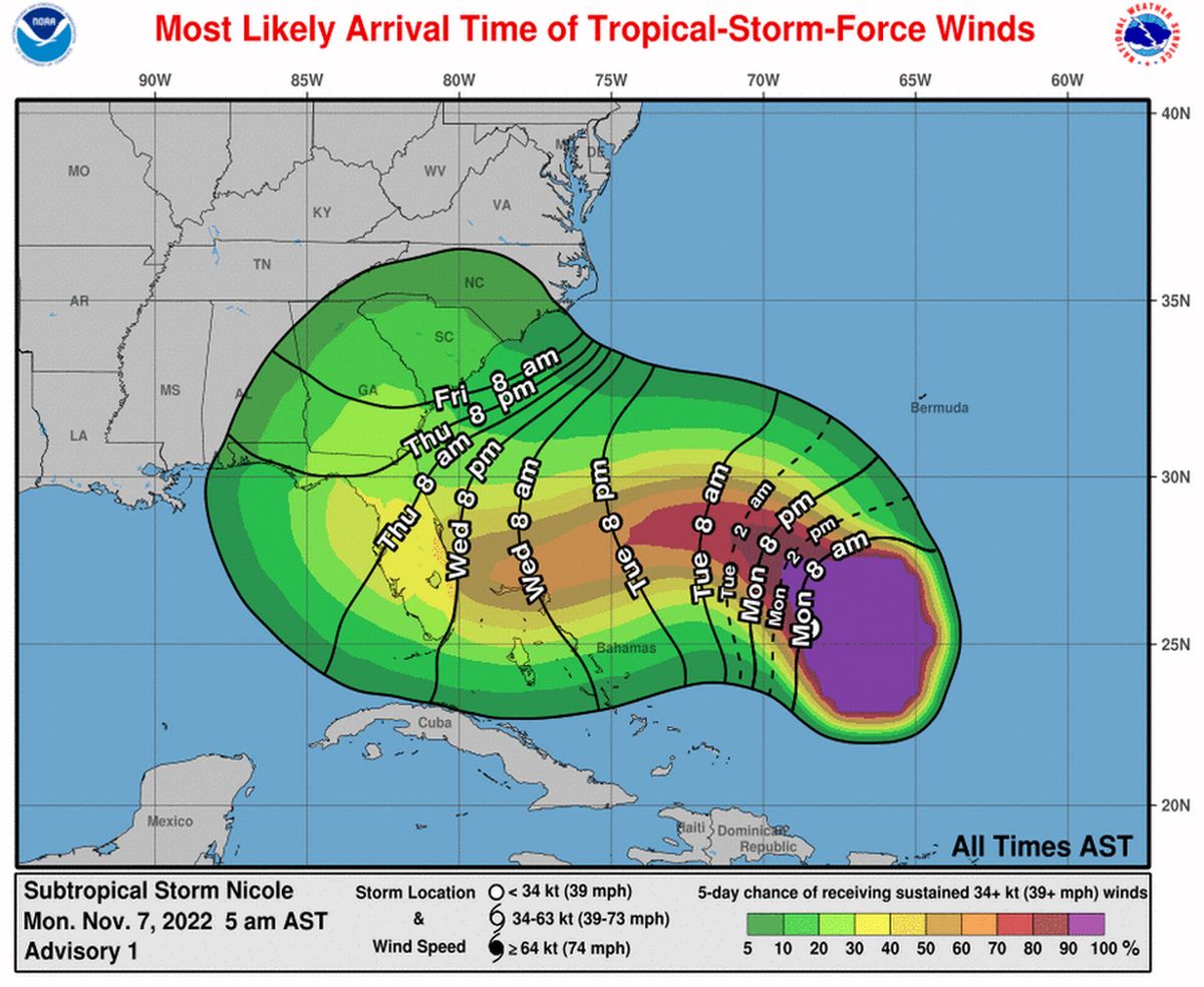
Overnight, the National Hurricane Center nudged its predicted track north toward Melbourne, moving Miami-Dade and Broward out of the cone of uncertainty, but Nicole’s wind field is already nearly the size of the entire state, so its effects will be felt throughout Florida starting as early as Wednesday.
Hurricane watches on Florida’s east coast were upgraded to warnings on Tuesday for most of the coast, except Broward and Miami-Dade, which remained under a hurricane watch and tropical storm watch, respectively.
In addition to the hurricane watches already issued along Florida’s east coast, the hurricane center early Tuesday upgraded the east coast’s tropical storm and hurricane watches to warnings and issued a tropical storm watch for portions of the state’s western coast.
Early Tuesday morning, an Air Force hurricane hunter plane investigated Nicole’s “large wind field,” according to an update from the hurricane center. The strongest winds are clustered to the north of the storm, bringing potentially bigger impacts for Northeast Florida.
Gov. Ron DeSantis has declared a state of emergency in 34 Florida counties, including South Florida. Officials in coastal counties warned that some evacuations might be needed, but none have been called yet.
Palm Beach County will close schools Wednesday and Thursday, and other east-central Florida counties may follow suit. Broward Schools Superintendent Vickie Cartwright said schools will go on as normal unless winds reach tropical storm force, which would force the buses to stop running.
Drawbridges in Miami-Dade County are being locked down to marine traffic. Locked bridges include those over the Intracoastal and the Miami River.
Florida Power and Light CEO Eric Silagy said that the utility is preparing for “widespread outages stretching over multiple days,”, especially in areas already hit by Hurricane Ian in late September.
“Ian saturated soil and weakened trees in many parts of the state, so Nicole could cause trees to topple over and other vegetation and debris to blow into overhead power lines and equipment, which may cause outages,” he said in a statement.
Flooding and rain for South Florida
As of 1 p.m. EST Tuesday, the National Hurricane Center placed Tropical Storm Nicole 310 miles northeast of the northwestern Bahamas and about 420 miles east of West Palm Beach. The storm, with sustained winds of 60 mph, was traveling northwest at 9 mph.
Earlier Tuesday, the center said Nicole transitioned from a subtropical storm — largely an academic distinction, but a sign that the storm has a bigger wind field and formed over cooler waters — to a tropical storm. By Wednesday it could be a Category 1 hurricane with 75 mph sustained winds as it comes ashore in Florida.
According to forecasters, South Florida could face flooding, heavy rain, a storm surge and high winds Wednesday night and Thursday as the storm slops across the coast. Hurricane conditions are expected in portions of the Bahamas on Wednesday.
The hurricane center predicts Nicole’s center will make landfall overnight on Wednesday or early Thursday, but the storm’s highest winds are concentrated to the north, so Northeast Florida could feel the brunt of Nicole’s winds a bit later.
Storm surge will peak on Wednesday, when tides are still running high from Tuesday’s King Tide, one of the highest annual tides. In Miami-Dade, the hurricane center predicts up to 2 feet of storm surge. That prediction includes the King Tide flooding.
Storm surge predictions get higher farther up the coast, with 2 to 4 feet expected in coastal Broward and Palm Beach counties, and 3 to 5 feet of surge expected from north of Palm Beach County to Jacksonville.
“The large wind field of Nicole is going to be moving a lot of water around in the next few days,” said Michael Brennan, acting deputy director of the National Hurricane Center, in a Tuesday morning broadcast.
That, coupled with several inches of rain across the state, could cause some serious coastal flooding. The hurricane center issued storm surge watches and warnings for most of the coast, and Miami-Dade is under a coastal flood advisory.
The National Weather Service’s Miami office predicts up to 8 inches of rain are possible in some spots, but levels will likely be stronger toward the north: around 4 to 6 inches in Palm Beach and Broward, with 2 to 4 inches expected in Miami-Dade.
The South Florida Water Management District has been lowering canals throughout South Florida to prepare for Nicole’s rain and surge since Sunday, and district spokesperson Jason Schultz said that the high King Tides haven’t slowed down the district’s ability to prepare.
“We have not encountered any issues with king tides hindering our ability to lower canals,” he said.
The storm’s projected path across the state also takes it north of Lake Okeechobee, which rose more than 2.5 feet with Hurricane Ian’s rains. High water levels from additional rain can potentially lead the U.S. Army Corps of Engineers to release some of that water to the east and west, which can aggravate red tide and blue-green algal blooms.
Army Corps Spokesperson Erica Skolte said the agency is paying close attention to the forecast and currently doesn’t expect Nicole’s rains to overtop the dike surrounding the lake and protecting nearby residents.
“Based on the most recent forecasts, our analysis indicates no risk of overwash for the common inundation zones around the Herbert Hoover Dike,” she said.
The latest hurricane center forecast shows Nicole heading northwest into Florida before turning north toward Gainesville Thursday afternoon while it’s just north of Orlando. From there, Nicole’s track takes it toward Valdosta, Georgia and up through the Carolinas, where it is expected to dissipate.