Tropical Storm Nicole, on the cusp of Cat 1 strength, nears Florida. Track nudged south

MIAMI – Tropical Storm Nicole, on the cusp of strengthening into a Category 1 hurricane possibly within hours, remained on track to cross the Bahamas Wednesday and slam much of Florida with pounding surf, high winds and heavy rain.
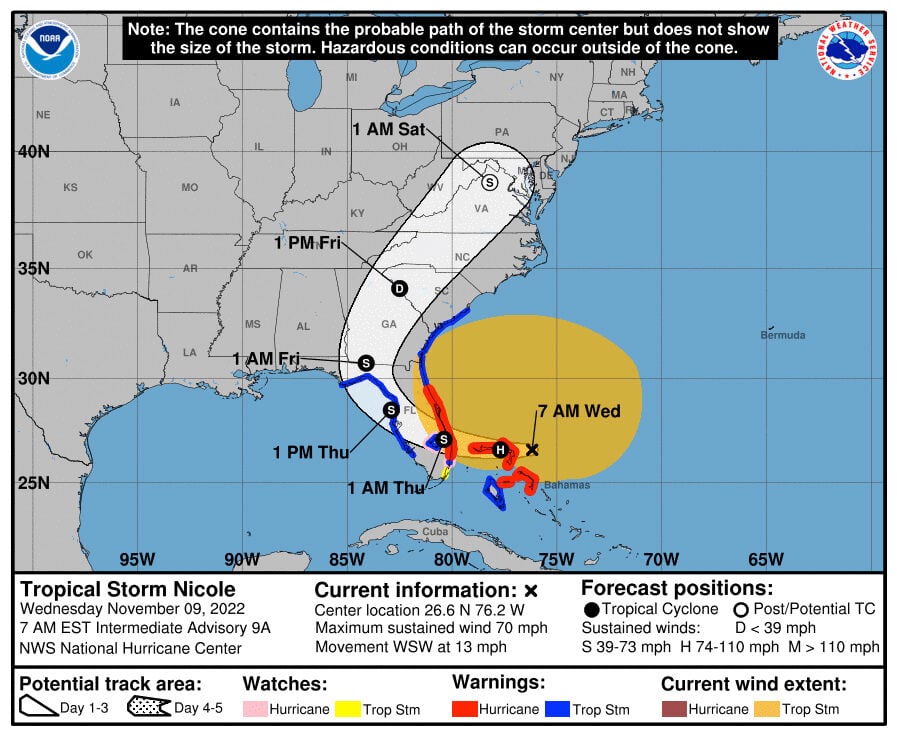
Forecasters also shifted the track slightly south – with potential landfall expected in the overnight hours near the Palm Beach-Martin County border – though that could still change. But regardless of where the center crosses the state, the sprawling storm’s wind field continued to grow overnight high winds and heavy rains will be felt hundreds of miles away – with the worst conditions likely on its northern side.
Many coastal and inland counties, including Miami-Dade, Broward and Palm Beach, had already ordered school closures for Wednesday.
With storm surge and beach erosion the biggest threat, mandatory or voluntary evacuations also had been called for tens of thousands along the coast, from Palm Beach north to Volusia County. Theme parks are closed, drawbridges are locked and Orlando’s International Airport plans to close down later in the day as the storm draws near.
In its 4 a.m. update, the National Hurricane Center said the storm was about 90 miles east-northeast of Great Abaco Island in the Bahamas and 270 miles east of West Palm Beach. Its maximum sustained winds had risen to 70 mph and it was headed west-southwest at 13 mph.
While Nicole is likely to prove damaging and spark widespread power outages, forecasters aren’t expecting it to get much stronger before it sweeps across the peninsula.
It is set to cross some warm ocean waters as it moves through the northern Bahamas, but forecasters said wind shear and other less friendly conditions will likely keep the storm in check and near Category 1 status.
Still, Florida faces tropical-storm-force winds that will reach much of the state, several inches of soaking rain and coastal flooding for most of the coast from multiple feet of storm surge – an elevated threat for counties like Brevard and Volusia that already lost protective beach sand from Hurricane Ian.
What to expect
Most of the state will see storm surge from Nicole, with a peak of three to five feet above dry ground for the northeast coast of the state. Coastal Palm Beach and Broward could see two to four feet, and Miami-Dade could see one to two feet.
This surge comes on the tail end of a King Tide event, one of the highest annual tides.
The west coast is also due for several feet of surge as the storm zig-zags its way inland before turning north, where it’s expected to cross through Georgia and follow the coast until it dissipates.
While Nicole will douse the state with several inches of rain, it’s not expected to be a dramatic rainmaker like Hurricane Ian. That’s because the storm is set to zip around the state at 15 mph, a speedy clip for a storm that prevents it from spending too much time over land and dropping too much rain.
The east central Florida area appears in for the most rain at around six inches, but South Florida could see up to four inches in Broward County and around two inches in Miami-Dade, according to the hurricane center.