Spokane weather balloons are collecting data helping guide Hurricane Ian forecasters

As forecasters frantically work to pinpoint where Hurricane Ian may land, they’re getting a little help in the Inland Northwest.
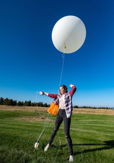
The Spokane office of the National Weather Service on Saturday began releasing four weather balloons a day into the atmosphere, twice the usual amount. It’s part of a nationwide effort by the weather service to collect more data that could better determine where the hurricane is headed. The extra data collection in Spokane is expected to last until Wednesday.
The idea is simple: The more real time data that’s collected – even from places like Spokane a couple thousand miles from the hurricane – the more likely models will better predict where it will land, said Ken Daniel, a meteorologist at the Spokane office located on the West Plains, one of 92 National Weather Service locations that release weather balloons.
“It all plays a part in the grand scheme of things,” Daniel said.
On a normal day, the weather service in Spokane releases hydrogen-filled balloons with tracking devices at 4 a.m. and 4 p.m. The weather service has added releases at 10 a.m. and 10 p.m. to gather the extra data for hurricane tracking.
Daniel said weather balloons often rise 20 miles into the air, well over twice as high as a commercial flight. It’s so high that, as a result of lower air pressure, the balloons expand from about 5 feet in diameter to more than 20 feet until they pop, falling to the ground with a small parachute to slow the fall of the data device called a radiosonde. Balloons can travel a couple hundred miles into North Idaho or into Montana if the wind is blowing from the west to the east, as it typically does.
Radiosondes measure wind direction, wind speed, air pressure, temperature and humidity.
Meteorologist Miranda Cote has worked at the weather service’s Spokane office since 2004. When she started, the radiosondes were bigger than a half gallon milk jug. They’ve shrunk over the years. Earlier this year, the office began using fist-sized devices made by the German company, Graw Radiosondes.
Previous models fell to earth with an envelope attached asking anyone who found them to place them in the mail to be refurbished and reused. The weather service said only about 20% were returned. The Graw devices, however, are considered disposable.
“This is a harmless weather instrument,” says writing on the Graw radiosondes to anyone who finds them. People who come upon one are advised to throw it away, unless they think of it as a souvenir.
The Spokane weather balloon from the release at 10 a.m. Monday popped about halfway between Mount Spokane and Newport, Daniel said. The balloon released at 4 p.m. popped when it was 113,054 feet high and landed about 15 miles north of Kellogg, Cote said. The temperature at the balloon’s highest altitude was minus 80.5 degrees Fahrenheit.
Data from all the weather balloons gets inputted into the weather service models. The more quality data that’s collected, the better the forecast, Cote said.
“The atmosphere doesn’t work in a vacuum,” Cote said. “What happens on this side of the country can affect what happens over there.”