This column reflects the opinion of the writer. Learn about the differences between a news story and an opinion column.
Spin Control: Here’s where to start to carve a competitive congressional district in Eastern Washington
Sometimes, when legislators try to send a message, they can’t always be sure that message will be received.
In response to controversial efforts to redraw congressional districts in several other states, a legislative committee has scheduled a hearing this week on a tit-for-tat proposal that would let Washington join the fray.
This despite the fact that changing the way Washington draws those boundaries is more difficult than in some states. It requires an amendment to the state constitution and needs two-thirds approval in both chambers, as well as approval by voters in the November election.
So even if they had the needed supermajority in the Legislature – which Democratic leaders acknowledge they do not – a redistricting couldn’t happen in time to affect the 2026 midterms, which is what started the rush to redistrict in the first place.
House Majority Leader Joe Fitzgibbon, of West Seattle, the prime sponsor, describes the proposal as part of a “fight for balanced and competitive” congressional maps around the country. He points to a redistricting effort in Texas that made several U.S. House districts more Republican, and proposals in other strongly Republican states to follow suit.
But he acknowledges that he doesn’t have the votes to get the amendment passed, at least this year, and that it could be described as “a messaging bill” or “putting out a marker.”
“Our job is to protect our democracy when it’s under attack. Should we disarm unilaterally?” he said last week when discussing the proposal, which would only go into effect if another state were to redraw its boundaries to change its partisan congressional advantage.
Setting the possible analogies to the Cold War and its Mutual Assured Destruction doctrine, one obvious question is whether Washington could actually redraw its current congressional districts – now represented by eight Democrats and two Republicans – to a bluer configuration.
Fitzgibbon said they would have to look at the population distribution and the precinct breakdowns to be sure. Maybe not 10-zip, but maybe 9-1. And if not a solid blue ninth district, maybe “you could devise a congressional district east of the mountains that’s at least competitive.”
But Democrats have not looked at either the population distribution or the precinct breakdowns from the most recent congressional elections to determine whether such a redrawing is possible.
If they had, they would have started with these hard facts:
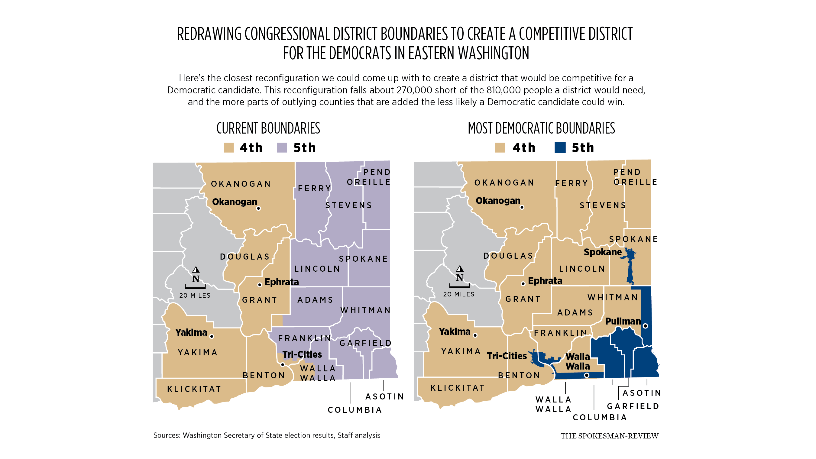
As it has for decades, the state has two congressional districts east of the Cascades, the 5th in Eastern Washington and the 4th in Central Washington. They have elected Republicans to the House for the past 30 years, and those are the Republican districts the proposal is aimed at.
Each district has to have one-tenth of Washington’s population, which as of last April’s state estimate was 811,510. There have been some shifts and some growth since the 2020 Census, so where all the people are is a bit of a guess, but let’s say the new district would have to be about 810,000 to pass muster as “equal representation.”
Based on recent election results, those two East Side districts might best be described as a sea of red with blue islands. Things can shift, sometimes dramatically. In 1990, Washington sent five Democrats and three Republicans to the U.S. House, with one from each party coming from east of the Cascades. After the 1991 addition of another seat, it sent eight Democrats and one Republican in 1992, with both east side districts Democratic. In 1994, it sent two Democrats and seven Republicans, both East Side districts Republican. The numbers in the West Side party split varied over the ensuing years, the East Side split has not.
The only areas of those two districts with consistent Democratic vote margins in congressional elections are in cities, with Spokane being the biggest, bluest island. Anyone drawing redistricting lines would have to start there.
Although Republican Mike Baumgartner carried Spokane County as a whole last year, Democrat Carmela Conroy carried the city of Spokane. The county as a whole has an estimated population of 566,000, which is about 70% of the way to the optimal size of the district, so you would have to remove the city of Spokane, with its strong Democratic margin, from most of the rest of the county, and head for Pullman, which also went Democratic.
But you can’t jump around and create a district of little blue islands – the precincts have to be contiguous, and there aren’t enough voters even if you could – so you’d have to pick up at least some Republican areas as you head south down the Palouse Highway. Once you hit the Whitman County line, you’d want to veer east, staying pretty close to the Idaho boundary, picking up as few precincts as possible – they’re all deeply red but not heavily populated – until getting to Pullman and capturing the university votes. Then continue down to where Whitman, Asotin and Garfield county lines form a point, and head west to bring those two and Columbia County into the new districts.
You can’t wall those counties off from a district in the rest of the state, and while deeply red, but they’re not heavily populated, so you can hope that the Republican margins won’t hurt the plan too badly. Just before the Columbia County line hits the Oregon border, you’d stop and start drawing the boundary west to bring in a narrow slice of south Walla Walla County until you get to the city of Walla Walla, which is another light blue island of Democratic leanings. Once outside the city, you’d find the narrowest path to Pasco, Kennewick and Richland, which sometimes have blue leanings, remove them from the 4th and graft them onto the 5th.
The margin would be something of a guess, because they’re in a Congressional District where both candidates in 2024 were Republican. One might interpolate a partisan split by looking at the U.S. Senate race between incumbent Maria Cantwell and Republican challenger Raul Garcia, with the qualifier that Cantwell had certain advantages like incumbency, name recognition and money a Democratic challenger won’t have.
Conroy’s lead coming out of Spokane was 9,968, but the deep red Spokane County precincts that stretch to the Whitman County line would knock at least 1,000 votes off that. Picking up the 3,745-vote margin she got in Pullman pumps that to 12,778, but the deep red margins in those three southeast counties narrow that lead by 5,931 votes, so back down to 6,782 in favor of the Democrat. Add the 1,000-vote Conroy margin from the city of Walla Walla and the potential of transferring a margin of up to 3,250 that Cantwell had in the Franklin and Benton precincts she carried, and a generic Democrat MIGHT have a margin of about 11,000 votes.
Such creative drawing of district boundaries is known as gerrymandering, named for a notorious redistricting in Massachusetts in 1812, that, if you squinted, sort of looked like a salamander. It was attributed to then-Gov. Elbridge Gerry (who pronounced his name with a hard “G”), the person who signed the legislation shortly before being elected vice president.
The redrawn district as described might be compared to a swan below the Spokane County line, while the part sticking up might be likened to the Eye of Sauron looking out from Mordor.
But those boundaries can’t hold. With all the blue islands, plus the three small southeastern counties, you’ve only got about 590,000 people. For the sake of argument, let’s say the areas that connect those little islands, which are either rural farmlands or small towns, have another 50,000. You could pick the ones that seem to have the smallest margins in favor of Baumgartner or Garcia, but they would definitely cut into the blue margin.
You’d have to find another 270,000 people in areas contiguous to the boundaries you’ve drawn. That can’t be done with a few precincts; it would likely require entire counties, where the Republican advantage vote margins varies between 60% to 75%, with no blue islands.
This also doesn’t account for the fact that splitting Spokane from most of the rest of the county – the only way you can start to approach a Democratic-leaning district – might be challenged in court.
Could you draw it a different way, like a series of horizontal districts that stretch from the heavily Democratic Puget Sound to the Idaho border? Maybe, but then you could tip some of those eight Democratic districts into competitive races, and that’s clearly not the goal. No one has tested that configuration, and it’s clear that Democrats are looking to gain, not lose, any advantage.
The amendment will get a hearing Wednesday in the House State Government Committee, as the committee chairwoman is a co-sponsor of the bill. It probably won’t reach the House floor because, in a short session, why take time on a bill that can’t pass?
Once they’re done sending a message – which some might interpret as “We’re mad as hell, but there’s not much we can do about it” – Democrats might start working on new messages. Ones that hit voters where they live and motivate them to cast ballots for those candidates, whether they have strong partisan leanings or not.