Keeping cool

Behind the massive mounds of lava enclosing Myrtle Beach Lagoon, beneath the beating sun and surrounded by a half-dozen locals slathering themselves with lotion, Shelley Conley slipped one bare foot into the Spokane River current and stirred the drink that makes her summers special. “I love the river. I grew up on the river. I’m a Valley girl,” Conley said before launching into a story about the river’s glittering sand and how her boyfriend, seeing it for the first time, mistook it for gold. It is gold, Conley told her beau – gold mica. The value of the sand is based more on the recreation it provides on hot summer days than what it might fetch on the precious metals market.
Spokane River beaches from the Idaho state line to Riverside State Park are the respite of the masses in the summer months. Local energy provider Avista Corp. tightens the valve on its lake dam in Post Falls in the late spring, and the sand surrounding the Spokane River widens for a stretch more than 30 miles long.
Out come the inner tubes, lawn chairs and coolers, and the white legs and pale bellies searching for a bronze tinge.
Admission is free, but there are consequences.
Sheriff’s deputies hand out $77 tickets for anyone in the water without a life jacket between the state line and Plantes Ferry Park. In the life jacket optional section, the currents can still be deadly.
And there are environmental concerns.
Arsenic and lead have been found in the shores between the state line and Plantes Ferry Park. Frequent beach visitors aren’t discouraged from using the beaches, but they are advised by the state Department of Ecology to shower after visiting the river and to wash anything that comes in contact with the shoreline.
The consequences haven’t chased away river runners.
“My husband, Rob, and I floated down on tubes,” said Danielle Warnock as she waded into the lagoon. The beach is everyman’s theme park.
They bought deluxe $40 inner tubes with nylon handles and bottoms over the holes from White Elephant last week and hit the river. Other floaters made the same journey on simple $6 rafts.
There’s a beach for every interest on the Spokane River.
A synopsis of beaches, beginning at the state line and traveling downstream to Riverside Park, follows:
There are a handful of great hangouts near the Idaho state line, beginning just upstream from the Interstate 90 bridge and continuing downstream for roughly two miles.
The Centennial Trail passes right under the bridge, and there is a trail down to a flat, rocky beach just south of the bridge. This is not a heavily used beach, despite nearby parking at the state line rest area.
Downstream from the I-90 bridge, is Dead Dog Hole, a whitewater feature on the Spokane River’s north bank where kayakers perform stunts at high water. Local kayak lore explains that when the hole was discovered, a dead dog swirled in the feature’s powerful undertow.
Less than a mile downstream in the center of the river is Pine Forest High-Water Island, a site with sandy beaches. Caution signs are posted at most sites along this portion of the river due to lead and PCBs deposited in the soil.
Harvard Road Bridge, just north of Liberty Lake is a popular beach and canoe launch. The north bank features a wide beach with gentle slopes. In midsummer, the water levels are shallow for several yards away from the north bank but deepen quickly on the south shore.
People have been known to camp on the north bank at Harvard Bridge, though there are signs prohibiting it. This is a beach where cars can drive almost down to the water.
The south end of the bridge features a paved parking lot and a restroom.
Barker Road Bridge, roughly two miles downstream from Harvard Road is the next area with easy access. There’s parking and a bathroom on the south end of the bridge.
On the north end, there’s a great spot for launching boats or getting your feet wet. The water between Harvard Bridge and Barker Bridge is just deep enough to accommodate floating almost all summer, making the beach at Barker a good spot to take out. ‘
However, the bridge is also a popular launch for kayaks and canoes bound for Mirabeau Park.
The terminuses for both Mission and Flora roads on the south bank of the Spokane River feature piney beaches. Both beaches are fairly rocky and frequently used by boaters and anglers.
Beware – the water deepens quickly at these beaches, which also feature fast currents. Many of the people swimming in these areas wear life jackets.
Sullivan Park, on the north end of Sullivan Bridge, doesn’t feature much of a beach, but it does have large boulders jutting up from the water that attract swimmers. In this stretch of the river, the Rathdrum Prairie-Spokane Valley Aquifer pours water back into the river, creating chilly swirls in the current.
Water can be seen seeping from the banks. Parking is available on both sides of the river. The walk down to the river’s edge is steep.
There is a small beach on the south bank and downstream from Sullivan Park. Fans of this area warn of strange undercurrents and say life jackets are advisable.
This stretch of the river regularly smells like doughnuts; there’s a Krispy Kreme above the south bank.
Mirabeau Park is the most developed beach area in Spokane Valley. Ample parking and restrooms are provided. There’s a manmade waterfall a few hundred yards above the river at the park’s south entrance. The south beach isn’t known for sand, but rather a massive, semismooth boulder that slopes downward toward the water.
This is a deep spot in the Spokane River and also a home to a major industrial site, Kaiser Aluminum, on the north bank. Rafters from Harvard and Barker roads frequently take out here.
Plantes Ferry Park, home to a large soccer complex, features a picnic area and access to a small beach in a shallow bend of the river. There’s a statue of Spokane pioneer Antoine Plante, who profited ferrying people across the river at this site before the river was bridged.
Parking is available at the park on the north side of the river. Arbor Crest Winery is perched on the rocks above the area.
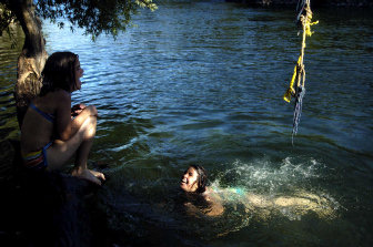
Just downstream from Plante’s Ferry Park proper is a parking lot and footbridge leading to the south side of the river. On the river’s south side and slightly downstream from Plantes Ferry is Myrtle Point Lagoon, a popular, secluded beach.
Massive lava boulders, roughly forming a half circle in the river, hide the south beach from public view and create a lagoon of sorts in the midsummer. This is a popular beach that usually has to be shared.
In the spring, when the water is high, the water splitting the rocks contains turbulent undercurrents and is not safe for swimming. The water gets deep quickly here and can be dangerous.
Donkey Island features a seldom used beach on the north bank of the Spokane River less than a mile below the Plantes Ferry Park footbridge. Parking is not provided.
The beach is easiest accessed by floating the river or walking the Centennial trail from Plantes Ferry Park. The island is more of a peninsula, the tip of which features a pebbly beach and ample driftwood for bench seating.
This area is the beginning of the reservoir created by Upriver Dam. The water is calm and deep.
Water-skiers and motorboats are not uncommon on this stretch of the Spokane River.
Boulder Beach, just upstream from Upriver Dam on the north side of the Spokane River, is appropriately named. The beach consists mostly of giant rocks towering above the calm depths of the Millwood reservoir.
Parking is available off Upriver Drive.
This area features geese, a grassy hillside and towering pines on the north bank. On the south bank, there are seaplanes docked at Felts Field, a small, mostly land-based airstrip west of Millwood.
There is a small, sandy beach on the south bank of the Spokane River just upstream from the Mission Avenue Bridge. This spot is easily accessed from the bridge, which hovers over some of the beach.
A neighborhood swimming spot, this is the location where a 13-year-old boy drowned in early June 2003. The tragedy underscored two things: the importance of life jackets for boaters and swimmers alike and the dangers of swimming where lifeguards aren’t present.
The site is well below the Plantes Ferry Park footbridge where sheriff’s officers stop citing people for not wearing life jackets, but the water is still dangerous. Several people watched the boy being swept away by the current but did nothing to help him.
He drowned in 18 feet of water.
People’s Park is another area of potential dangers along the Spokane River. Roughly a mile west of the Monroe Street Bridge in downtown Spokane, the park features a string of bridge abutments that can be difficult to maneuver. A child nearly drowned at the site during a canoeing accident this spring.
The park is the site of a popular beach, a well-used stretch of sand that is a haven for nudists. Parking is available from Riverside Drive.