Acres and acres of sand

GREAT SAND DUNES NATIONAL PARK, Colo. – All it needs is a camel, maybe a Bedouin tent, or a couple of date palms. The place is that deserty.
It’s a park centered around mounds of sand that go on for 30 square miles, right up against the sort of Colorado landscape one has every reason to expect: mountains with snow on top, rushing creeks, cactus, sagebrush, aspens, cottonwoods and ranchland dotted with grazing bison.
The sand is what catches attention, some of it piled nearly eight stories high, magnificent but highly incongruous – as if Hollywood remade “Lawrence of Arabia” as a Western.
The Great Sand Dunes area has fascinated people since they first laid eyes on it. Last year, the dunes earned a promotion to national park from their former rank as national monument, due to some land acquisition and a few new national park-level facilities.
I found the dunes mesmerizing when I first saw them some 20 years ago, and when I revisited them again last fall, I observed that they hadn’t lost a grain of magnificence. Up close, they resemble a transplanted desert from Africa or the Middle East, changing colors and forming shadows, rippling and shifting.
They almost deserve to remain a mystery, one of those natural phenomena too majestic for human comprehension. But, of course, people have almost figured out why those dunes appeared – almost, but not quite.
Carol Sperling, the park’s interpretive officer, started the explanation by pointing out that the modernistic visitor center where we were sitting is on the east side of the Great Sand Dunes. To the west are the San Juan Mountains, and farther east are the Sangre de Cristos. The land beneath the visitor center and under the dunes is the San Luis Valley. This is a portion of the Rocky Mountains’ front range.
The sands started to accumulate around 12,000 years ago, although the exact age still eludes scientists.
“The geologic explanation that’s accepted right now,” Sperling said, “is that most of the material started over there in the San Juans and was brought down out of those mountains by various streams that went across the valley floor.”
Most of the material in the dunes matches the material in the rocks of the San Juan Mountains. Streams and prevailing southwesterly winds push the material up against the Sangre de Cristo Mountains. Those mountains and occasional gusts of northerly winds hold the sand in place.
“The part that’s not totally clear right now is what happened in between the time the material was getting out to the valley floor and ending up over here,” Sperling said, waving toward the immense wall of sand outside her office window.
“This is just a supposition,” she said, “but it sounds pretty plausible, based on what we can see, that there was a big, long skinny series of lakes that might have been wetlands or seasonal lakes and that the (sand) ended up in those bodies of water.”
After the lakes dried up, goes the theory, the sand was free to pile up against the Sangre de Cristos, leaving the impressive dunes we see today.
The visitor center where Sperling works is filled with fascinating displays, including a device that shows how various wind patterns play across a miniature San Luis Valley. Walls of photographs provide a peek at the many faces of the Great Sand Dunes – pink in the morning and afternoon, purple at dusk or littered with seemingly improbable clumps of snow.
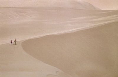
I drove up the road to a parking lot where I could begin a trek across the dunes. Others were far ahead of me, mere specks on a broad surface that mid-afternoon sunshine rendered a soft beige – you know, the color of sand.
The recreational possibilities of the Great Sand Dunes weren’t lost on the people who showed up that day. Two little boys slid down the slopes on plastic disks. Several visitors walked their dogs, and other folks walked themselves.
Hiking on sand thoroughly engages the calves and thighs; the footing shifts constantly and often abruptly. Shoes sink in. I envied those who made it all the way to the top of High Dune, as it’s called, but I settled for a lesser, unnamed summit.
Besides missing the heights of High Dune, I also came in the wrong season for water sports. “In spring, Medano Creek is like a Mecca for people who are desperate for the beach but live in Colorado and don’t get to the coast very much,” Sperling had told me.
Not far from the dune field parking lot, I could see the dry, shallow trench identified as a section of Medano Creek. The creek skirts the east and south sides of the dune mass.
In the spring, melting snow from the mountains turns Medano Creek into a sort of river. It might get as deep as 18 inches and moves with an energetic current. Little underwater dunes form, and when they become tall enough, water crashes over their crests, causing surf that breaks about every 20 seconds. This is called surge flow.
And right next to it is a beach as natural as beaches get. Bring your folding chair and that inflatable ball.
“As a result,” Sperling said, “in spring every kid and every adult who still feels like a kid splashes and plays and jumps around in the water, and they let the surge just carry them downstream. It’s hysterical fun, really.”
In the days of the Old West, the San Luis Valley might not have been such an amusing place. Ute Indians established the first permanent community in the area around 1500 A.D. In 1765, Spanish explorers combed the Sangre de Cristos and San Juans looking for silver and gold.
Some Spaniards settled into the area, but not without conflicts with the natives who already lived there.
At the beginning of the road that leads into the park from the west, a signboard welcomes visitors to the “Caminante Los Caminos Antiguos Scenic and Historic Byway” (also marked as rural route 6N).
It’s a large sign that has a lot more to say. “You have entered the land of the Rio Bravo del Norte, the northernmost outpost of 16th Century Spain,” it announces.
In the old days, the city of Alamosa was named Rio Bravo, and the Rio Grande still flows through the downtown. The eastbound road with the sign that ushers you into the valley begins in the town of Mosca and is one of those great Western asphalt lasers that cuts straight across scrubby high-desert toward the imposing purple slopes of the Sangre de Cristos and the Great Sand Dunes.
It takes no great feat of logic to figure out who named those mountains Sangre de Cristo (Blood of Christ) and San Juan (St. John).
That same sign of welcome rather plaintively tells the story: “To the Spanish people, the San Luis Valley was the wild and unexplored place known only to the native people. Amidst the beauty and color and peaks of the valley, the area became the center of conflict and wars born of a clash of cultures.”
The sign goes on in the collective voice of Spanish settlers:
“We arrived in the San Luis Valley with our religion and culture, looking for fertile ground to raise our families. We laid out plazas, shared common ground and relied on each other to survive in an unknown place.
“We did not understand the native beliefs and soon found ourselves in conflict with the native people. We fought great wars to protect our Spanish communities. Distance cut off our colonies from our homeland. We were alone on the frontier. Over time, we wove a culture that was closely tied to our religion and to nature, making the San Luis Valley a unique culture of its own. – The people of the San Luis Valley”
Descendants of the Utes also still live in the area that their ancestors first settled, and they constitute the oldest continuous body of residents in Colorado, according to state-government historians.
Farther out on the road from Mosca, I passed the San Luis State Park and San Luis Lakes Wildlife Area, and the Medano-Zapata Ranch, owned by the Nature Conservancy.
The dunes area enjoys federal protection due to efforts by the people of the San Luis Valley. Because citizens campaigned and insisted, in 1932 President Herbert Hoover declared the dunes and some surrounding land the Great Sand Dunes National Monument.
The dunes were in danger. Miners had been sifting the sand for gold with some success and concrete producers were beginning to haul away the sand.
The national monument designation was a victory for concerned residents, but they wanted more. Over the years, they campaigned to raise the monument to a higher National Park Service category.
On Nov. 22, 2000, President Bill Clinton signed the Great Sand Dunes National Park and Preserve Act of 2000, which authorized an expansion that would quadruple the monument’s size and eventually lead to its becoming a national park.
Some 42,000 acres of adjoining national forest were transferred to the National Park Service and renamed as a national preserve. That allowed the park to include mountainous areas with aspens, tundra, alpine lakes and wetlands. The Bureau of Land Management turned over more acreage on the south and west sides of the old monument boundaries.
On Sept. 10, 2004, the Nature Conservancy purchased the Baca Ranch on behalf of the federal government. This vast tract had included the northwestern corner of the dunes and was considered essential to protect the park’s upper flank.
That was the last piece of the puzzle, and on Sept. 13, 2004, Interior Secretary Gale Norton declared the Great Sand Dunes a national park, the nation’s 58th.
On one of my visits to the park last fall, I hiked a short trail that followed a loop near the visitor center. Plaques along the way identified native plants common to a desert environment some 8,000 feet above sea level.
Another sign marked a trailhead leading to Medano Creek and that imposing wall of sand just a meadow’s width away.
I saw the head of a mule deer poke up from the tall grass about 30 yards distant. He looked at me. Then another head popped up, and another. I counted 10 deer. They were grazing on sand that had failed to make its way to the major dune field, the sort of sand that allows plants to grow and nourish native animals.
The deer’s presence reminded me that even though a national park has one astounding feature – or many astounding features – its most important role is sustaining the cycles of nature. Mountains played their part by delivering sand and trapping it, demonstrating the odd things that can happen in geological moments (and 12,000 years is a geological moment). Plants do their part by helping to sustain wildlife and cleaning the air.
Humans get to enjoy the sights and revel in the solitude, learn something about the Earth and the power of the elements.
They can get sand for their concrete somewhere else.